Only in Dubai: Municipality's Makani map to provide address for each flat and shop
Municipality envisions drone delivery in each building unit with Makani indoor navigation


Dubai: Imagine drones delivering your online orders at your flat in a Dubai building. The emirate is one step closer to that ambitious vision with the Dubai Municipality coming up with a project to give digital geospatial address to each unit in all buildings for indoor navigation.
It may sound like it is time for Google Maps to move over soon since Dubai Municipality’s futuristic project using its indigenous navigational map Makani is going to let people, emergency services and even drones find location map of each flat and shop in all buildings through in the next three years.
An extension of the existing 10-digit Makani digital addressing for building entrances, the new system will include a six-digit alphanumeric code for all types of units within the buildings — whether they are residential units, shops, offices, etc. Said to be the first-of-its-kind in the world, the system assigns a code similar to DMHQ01 for each unit.
Makani system
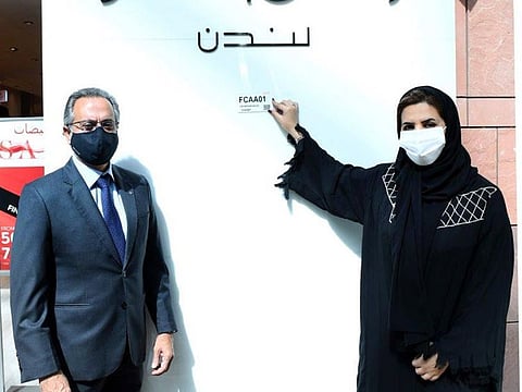
Dubai Municipality on Thursday launched the Makani smart system for geospatial unit addressing for shops at Dubai Festival City. Marks & Spencer at Dubai Festival City became the first shop to get a unit address plate, Maryam Al Muhairi, director of the GIS Centre in the municipality, told Gulf News. “Makani for unit addressing concept consists of a unique numbering.”
The official said the GIS Centre gave the priority to The Festival City to choose unique unit numbering: FCAA01, abiding by the approved code. The first code plate was placed there and following an agreement signed with the mall after prior coordination with the Smart City. “They were given the choice only because of being our first partner. Other areas will follow the standards sequence,” said Al Muhairi.
Also Read: Digital address app helps map Dubai
The municipality estimates to complete addressing all units in the shopping mall by the end of this year. “If we are talking about the whole emirate, we should put at least three years of time,” said Al Muhairi.
“We are working on addressing many different locations in Dubai and we have many entities in Dubai requesting for addressing their buildings. The addressing system at the unit level is a huge project, and it requires to include the units inside the buildings, and infer the building, floor and unit.”
How will it help
Al Muhairi stated that the new unit addressing system is considered one of the futuristic systems, as it will be used in all government services to access locations of units related to emergency services, statistical data and delivery services.
“It is expected that in the future, there will be widespread uses of drones and self-driving vehicles in government, commercial and tourism services, which requires accurate address systems at the level of details of units within the buildings along with 3D databases with high accuracy, which will be provided through this integrated modern addressing initiative.”
Unit addressing
The project aims to enhance the integration procedures with the service authorities, as the Unit Addressing will be an integration point between all government authorities, that provide services on a unit level.
“Our main goal is to help simplifying the addressing system and facilitating the process of accessing the units, especially in times of emergency and crisis, and will be linked with all vital authorities in the emirate, such as Dubai Police, Civil Defence, Dubai Ambulance … etc”
So, how is it expected to support drone delivery?
“For sure, having an accurate address and a navigation system will help reach the destination in less time and free of hassle. In addition to the building 3D data will be the precise reference for drone navigation,” explained Al Muhairi.
Once the distinctive code has been set for each unit, Makani will be installed for the units, preparing mobility data within the buildings.
The engineering data for the buildings have been prepared according to 3D standards consistent with the GeoDubai initiatives and the Digital Twin requirements of the emirate and its inclusion in the geographical database facilitating the digital addressing of each and every unit in all buildings.
Smart geospatial system
A smart geospatial unit addressing system is one of the most important smart components in a vibrant emirate like Dubai, which is visited by more than 10 million tourists annually pre-COVID 19 times, and more than 200 nationalities reside in it.
“We are keen to launch specific initiatives that contribute to achieving the vision of His Highness Sheikh Mohammed bin Rashid Al Maktoum, Vice-President and Prime Minister of the UAE and Ruler of Dubai in transforming Dubai into the smartest city in the world. It also proves our seriousness in creating a global model for the implementation of the smart city concept,” Al Muhairi said.


