'Erratic', 'violent' super typhoon Hinnamnor: Sept. 2 updates
Supertyphoon packs winds of up to 241 km/h, heading toward southern Japan
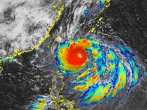
Super Typhoon Hinnamnor is now barrelling towards the southern islands of Japan, packing winds of up to 241 kilometres per hour (150 mph). Here’s what we know so far about the weather system.
Category:
As a Category-5 hurricane, Hinnamnor is the world's strongest tropical cyclone recorded so far this year. On Thursday night, the supertyphoon was moving south of Miyakojima Island at a speed of about 15 kilometers per hour, Japanese weathermen said.
The storm is predicted to regain force as it moves south of Okinawa on Friday (September 2), after hammering parts of northern Philippine islands Thursday.
Erratic, violent:
It is the 11th tropical storm of 2022 that has developed into a typhoon. Meteorologist Dr Jake Carstens stated on Twitter that it has "textbook traits" of strongest storms — "almost perfectly concentric eyewalls and self-induced erratic wobbling motion".
On Thursday, weathermen at the Japan Meteorological Agency (JMA) upgraded the typhoon’s classification to "violent".
Location | Path:
On Friday (September 2), Hinmamnor (codenamed “Henry” in the Philippines) is seen moving south of Okinawa, Japan, where it is predicted to remain "stationary". Over the weekend, from Saturday to Sunday, it will approach Japan’s Sakishima Islands and Okinawa’s main island, as wind speeds continue to increase.
Movement:
As of the time of posting, the supertyphoon was seen moving south of Japan’s Miyakojima Island at a speed of about 15 kilometers per hour, JMA reported. While it is predicted to ”slow down and stall”, the system is predicted to continue moving north, towards the direction of Naha and Nago, in southern Japan.
Expansion:
It has rapidly intensified into a super typhoon category even as it “expands” — by gobbling up other local meteorological systems. Weathermen said the escalation of Hinnamnor is kicked up by warm tropical waters and other pre-existing meteorological disturbances.
Areas | cities affected:
Mainland Okinawa and southern islands are set to be hit. Taipei and Shanghai are likely to be the two major cities to be affected by the cyclone's movement, according to weather.com. Southern parts of South Korea will also be affected alongside the Chinese coast.
Warnings:
JMA has warned of flooding, heavy downpour, landslides, and possible lightning strikes, particularly in low-lying areas. The weather department has also warned of tornados, swollen rivers and violent winds. Up to 10-metre waves are expected in the Okinawa region.


