Also In This Package
Aston Martin launches Dh272,000 racing simulator
Millions return to school in Italy after virus closure
The 'Queen' of Controversy: Kangana Ranaut
Pandemic forces 'pink farm' to get creative in Brazil
Camel racing storms back in Sinai after COVID-19 hiatus
Pictures: Schools and colleges reopen in Pakistan
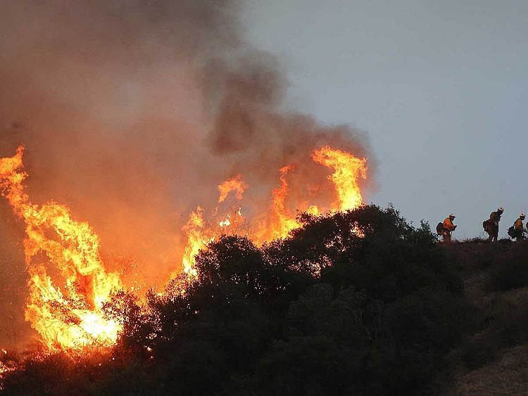
Berlin: Satellite images show that smoke from wildfires in the western United States has reached as far as Europe, scientists said Wednesday.
Data collected by the European Union’s Copernicus Atmosphere Monitoring Service found smoke from the fires had travelled 8,000 kilometers through the atmosphere to Britain and other parts of northern Europe.
Also Read
As Oregon fires burn, smoggy air suffocates Portland residentsTraumatized Beirut watches new fire burn at the port, a month after blastPhotos: California wildfire prompts new evacuationsThousands spend third night in the open after Greek migrant camp fireThe European Centre for Medium-Range Weather Forecasts, which operates some of the Copernicus satellite monitoring systems, said the fires in California, Oregon and Washington state have emitted an estimated 30.3 million metric tonnes of carbon.
“The scale and magnitude of these fires are at a level much higher than in any of the 18 years that our monitoring data covers, since 2003,” Mark Parrington, a senior scientist and wildfire expert at Copernicus Atmosphere Monitoring Service, said.
Parrington said the smoke thickness from the fires, known as aerosol optical depth or AOD, was immense, according to satellite measurements.
Sign up for the Daily Briefing
Get the latest news and updates straight to your inbox
Network Links
GN StoreDownload our app
© Al Nisr Publishing LLC 2026. All rights reserved.