Typhoon Kammuri packs winds of up to 215 km/h. It is set to hammer the islands as it makes landfall early on December 4, at around 2am.
UPDATE
Philippines: Monster typhoon Kammuri poses serious threat to island nation
#PrayforthePhilippines: Typhoon-prone archipelago takes direct hit from Kammuri
Last updated:
4 MIN READ
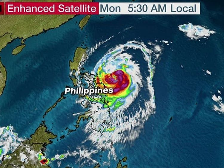
Kammuri's path: Flooding, storm surge and strong winds are concerns, including the main Luzon island, where the capital Manila is located.
Twitter / Weather channel
Typhoon Kammuri, known locally as "Tisoy", is strengthening as it tracks west toward the Philippines. It has made landfall in Gubat, Sorsogon, Philippine Atmospheric, Geophysical and Astronomical Services Administration tweeted on Monday night. The typhoon is expected to mimic the effects of a major hurricane on landfall, which was expected to be either late on Monday night or early Tuesday morning.
The Manila International Airport Authority (MIAA) announced on Monday that all Ninoy Aquino International Airport (NAIA) airport terminals will be closed from 11 am until 11 pm on December 3, Tuesday in the anticipation of the inclement weather brought by Typhoon “Tisoy” (Kammuri)
Local government councils in Bicol region, where Typhoon Signal No. 3 has been raised, have urged citizens to evacuate from shoreline communities due to an expected storm surge of up to 8.5 metres.
168 km/h
(105mph) is the speed of Typhoon Kammuri when it makes landfall early on Tuesday, December 3, in eastern Philippines.
Landfall in Samar is expected late Monday or early Tuesday local time. The storm's "eye" has been tracked moving at about 100km every 20 hours.
The storm is packing winds of 150 km/h (93 miles per hour), but those are expected to speed up to 185 kph (115 mph).
Southern Luzon is forecast to receive 20 to 30 centimeters of rain (8-12 inches), which will bring a risk of flash flooding and mudslides. Top wind gusts could hit 200 kph (124 mph).
Kammuri is forecast to strengthen to the equivalent of a Category 3 hurricane.
Along with a storm surge, damaging winds, flooding rain and mudslides are expected to accompany Kammuri as it hammers the island nation.
Thousands flee
Thousands of residents on the Pacific-facing side of eastern Philippines had started moving to a safer ground on Sunday ahead of the monster typhoon.
Packing gusts of up to 150 km/h as of December 1, Kammuri is expected to pick up speed before it hits land.
The monster storm is set to kick up "storm surges" of up to 8.5 meters — potentially inundating vulnerable sea-side villages and towns in the archipelagic republic.
Storm Surge
A storm surge (or storm flood, tidal surge or storm tide) is a coastal flood or tsunami-like phenomenon — an abnormal rise in seawater level during a storm, measured as the height of the water above the normal predicted astronomical tide. The surge is caused primarily by a storm's winds pushing water onshore.
On December 2, winds of up to 215 km/h are expected as the typhoon approaches the islands, before making landfall early on December 4, at around 2am, with winds of up to 150 km/h.
The local governments and disaster risk reduction councils in Bicol and Samar have taken preventive action — evacuating of thousands of residents.
Location of typhoon Kammuri as of December 1, 2019.
The two regions are expected to bear the first brunt of the typhoon, locally known as #TisoyPH.
Based on the NOAA latest satellite imagery, Kammuri is holding so much volume of water larger than that of super typhoon Haiyan (local name: Yolanda).
For now, Kammuri's power is less than that of Haiyan. But the rainfall intensity of Kammuri is a concern: Torrential rainfall is the highest and strongest among rainfalls on planet Earth.
Based on satellite images, Kammuri looks bigger than the entire archipelago of the Philippines, which comprises 7,641 islands, with a land area of about 300,000 km2.
On December 2, the outer circle of the raging typhoon Kammuri will start to be felt by Bicol Region, Samar and some parts of Leyte. It will intensify on the night of December 2.
In 2013, Typhoon Haiyan (Yolanda) caused catastrophic destruction in the Visayas, particularly on Samar and Leyte, not far from the regions now threatened by Kammuri.
As Haiyan made landfall in the Philippines at Guian, Eastern Samar, the Joint Typhoon Warning Center (JTWC) in Hawaii estimated the typhoon's one-minute sustained winds at 315 km/h (195 mph), making it one of the strongest typhoons of the 21st century.
Bodies piled in streets as makeshift mortuaries are overrun following the devastation left by supertyphoon Haiyan in November 2013 in Leyte. Most of the victims were buried in mass graves.
Haiyan killed up to 18,000 people, affected about 11 million people and left thosands mo homeless, according to the UN.
Hammered by typhoons
Approximately 20 tropical cyclones enter the Philippine area of responsibility yearly, an area which incorporates parts of the Pacific Ocean, South China Sea and the Philippine Archipelago. The Tawi-Tawi province, composed of small islands in the country's southwest, is rarely visited by typhoons. Among these cyclones, 10 will be typhoons, with five having the potential to be destructive ones. The Philippines is "the most exposed country in the world to tropical storms" according to a 'Time' magazine article in 2013. In the Philippine languages, tropical cyclones are generally called bagyo. The deadliest overall tropical cyclone to affect the Philippines is believed to have been the Haiphong typhoon which is estimated to have killed up to 20,000 people as it passed over the country in September 1881.
Network Links
GN StoreAbout Gulf NewsTerms & ConditionsReach by GNSitemapContact usPrivacy PolicyGN FocusHave your sayWork with usAdvertise with usGulf News epaperPrinting Services
Download our app
© Al Nisr Publishing LLC 2026. All rights reserved.