Oman declares holidays and school closures in Dhofar, Al Wusta amid cyclone Tej threat
Emergency shelters activated in the sultanate in anticipation of cyclone Tej’s arrival

Dubai: As Cyclone Tej intensifies in the Arabian Sea, the Sultanate of Oman is taking precautionary measures to ensure the safety of its citizens and residents.
The Ministry of Labour has declared a two-day holiday on October 23 and 24 for both public and private sector employees in Dhofar Governorate and Al Jazar Wilayat in the Al Wusta Governorate.
Additionally, the Ministry of Education has decided to close all public and private schools in the Dhofar region on October 22 and 23, in line with weather warnings. The ministry aims to prioritise the safety of students during this turbulent period. Schools are expected to resume on October 24.
Salalah port shut
Oman's Salalah port will be temporarily shut down starting from Sunday 5pm due to Tej, the state news agency reported on Saturday.
Public transportation is also affected as Mwasalat, the national transport company, has suspended all bus routes within Salalah city from 12pm on October 22, and halted the operation of Route 100 and Route 102 until further notice.
Ferry services on Al Halaniyat – Taqa route are suspended, although operations on the Shannah-Masirah route and routes to and from Musandam Governorate continue as usual. Mwasalat confirmed that it’s closely monitoring the situation and will keep the public updated on service resumptions through its platforms and social media channels.
In preparation for the anticipated cyclone, the National Center for Emergency Management (NCEM), in coordination with local authorities, has established 32 shelters in Dhofar Governorate and three additional in Al Wusta Governorate.
Evacuations
The NCEM will evacuate people of the areas expected to get the direct impact of Tejincluding Al Halaniyat Islands in Dhofar Governorate and the coastal parts of wilayats of Salalah, Rakhyut and Dhalkut.
The NCEM members were told to take necessary steps to support response operations and to provide required resources in places that are expected to be affected by the tropical cyclone.
These shelters, equipped with necessary food and water supplies, are ready to accommodate over 11,000 people seeking refuge from the adverse weather conditions.
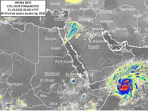
Meteorological data indicates that Cyclone Tej is intensifying and is likely to escalate to a category 4 cyclone within the next 24 hours. Currently categorised as a category 3 cyclone, Tej is situated around 500km from the Omani coast, with wind speeds estimated to be between 100 to 112 knots.
The forecasts suggest that the cyclone will continue to move west northwest towards the coasts of Dhofar governorate and the Republic of Yemen, posing a significant threat of heavy rainfall, flash floods, and storm surges in these regions.
The Civil Aviation Authority has issued an advisory urging everyone to exercise maximum caution, avoid crossing wadis, steer clear of low-lying areas, and the sea during this period. The Ministry has requested all citizens and residents to stay vigilant, follow weather developments, and adhere to instructions issued by competent authorities as Oman navigates through the cyclonic storm.
Cyclone likely to cross Yemen coast on Tuesday
The India Meteorological Department said on Sunday the cyclone is likely to move North-West and cross the Yemen coast close to Al Ghaidah around Tuesday morning.
“ESCS “Tej” lay centred at 1130 hrs IST of 22 Oct SW Arabian Sea about 130 km east of Socotra (Yemen), 500 km S-SE of Salalah (Oman) and 500 km SE of Al Ghaidah (Yemen). Very likely to move NW and cross Yemen coast close to Al Ghaidah (Yemen) around early hours of 24 October as VSCS,” IMD posted on X (Formerly Twitter).
Earlier in the day, the weather agency said that the cyclone ‘Tej’ is very likely to intensify into an extremely severe cyclonic storm in the forenoon of Sunday morning.
“VSCS (very severe cyclonic storm) Tej lay centred at 2330 IST on October Oct 21 over SW Arabian Sea, about 330 km ESE of Socotra (Yemen), 690 km SSE of Salalah (Oman), and 720 km SE of Al Ghaidah (Yemen). Very likely to intensify further into an extremely severe cyclonic storm in the forenoon of October 22,” IMD posted on X.
Meanwhile, a depression has formed over the west-central Bay of Bengal, which is likely to further intensify into a deep depression during the next 24 hours, as per IMD.
“It is likely to move northwestwards during the next 12 hours, then recurve and move north-northeastwards during the subsequent 3 days towards Bangladesh and adjoining West Bengal coasts,” IMD said.


