‘Supertyphoon’ Hinnamnor set to hit Philippines
Category 5 supertyphoon packs winds extending outwards up to 320 km/h


Manila: Tropical cyclone Hinnamor, currently moving in north-west Pacific as a Category 5 “supertyphoon”, is expected to hit land in the Philippines on Wednesday night, according to weathermen.
Hinnamnor is seen packing typhoon-force winds extending outwards up to 320 km from centre, the Philippine Atmospheric Geophysical Astronomical Services Administration (Pagasa) reported Tuesday that Hinnamnor is currently moving 30 km/h to the west.
A Category 5 typhoon, the highest classification in the scale, consists of storms with sustained winds of at least 157 mph (233 km/h).
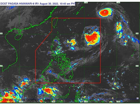
Currently as a tropical cyclone, satellite data shows Hinnamnor packs gusts of up to 205 km/h. It is forecast to make landfall in the Philippine Area of Responsibility (PAR) by Wednesday evening after maintaining strength as it moves west, according to the Pagasa.
Once inside the PAR, the tropical cyclone will be given the domestic name “Gardo”.
Pagasa said 11 am Tuesday, Hinnamnor’s eye was last observed at the extreme Northern Luzon region (26.8°N, 136.7°E), according to a state weather bureau bulletin.
It has a core pressure of 945 hPa, maximum sustained winds of 165 km/h around the center, and gustiness of up to 205 km/h.
What makes the Philippines prone to typhoons?
The island-nation sits at a boundary of the earth’s major tectonic plates while a huge part of its territory straddles the world’s notorious “typhoon belt”.
Result: The archipelago, beautiful in its own right and spread across 7,641 islands in the north-western Pacific, is hit by typhoons (and floods), landslides, earthquakes, volcanic eruptions — and droughts — on a regular basis.
Every year, up to 20 storms are hurled from vast Pacific to the Asian country. Some of that hit land directly, leaving a trail of devastation: at least 60% of the country's total land area — nearly 300,000 km2 (116,000 square miles), a place larger than either Arizona or Nevada — is vulnerable to these monstrous tropical cyclones.
The location of the archipelago along the path of the tropical storms coming in from the planet's biggest ocean, plus its located in the so-called “Ring of Fire” account for the higher frequency of these natural disaster triggers.
Why is it called the “typhoon belt”?
The term typhoon belt refers to a massive region in the west Pacific Ocean, which at 165 million km2, can fit all continents on the planet.
This “belt”, found in the western Pacific, is where nearly one-third of the world's tropical cyclones form. Typhoons usually move westward across the country, heading either north — or further west — as they go. Long-term climate data show that this area is not only the most active in the world, but also packs the most intense storms on the planet.
"Haiyan", called Yolanda in the Philippines, was the deadliest cyclone on record in the country, leaving more than 7,300 people dead or missing.


