Heavy rainshowers with lightning and strong winds are expected to pound at least 3 provinces south of Manila — Batangas, Laguna and Quezon — on Sunday as weathermen urged residents to take precautionary measures against the impacts associated with flash floods and landslides.
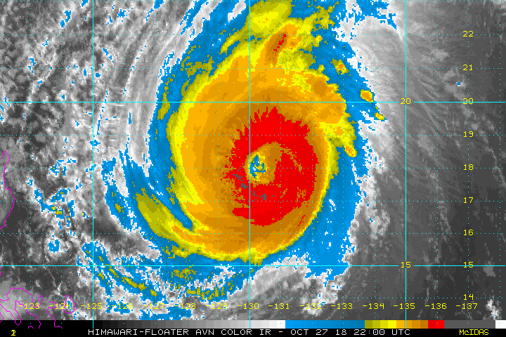
Check out the eye of Super Typhoon #Yutu in the western Pacific, seen today from #Himawari-8. The ferocious Category 5 storm is packing 180 mph winds and quickly approaching the U.S. territories of Saipan, Tinian and Rota. More imagery: https://t.co/naIsWtiBev pic.twitter.com/mo7PW10PaP
— NOAA Satellites (@NOAASatellites) October 24, 2018
RAINFALL INFORMATION
— PAGASA-DOST (@dost_pagasa) October 28, 2018
ISSUED AT: 5:15 PM 28 OCTOBER 2018
Expect light to moderate rains over #MetroManila, #Rizal, #Bulacan and #Pampanga within the next 1-2 hours.
The Pag-Asa weather bureau said that super-typhoon Yutu (locally known as Rosita) could rip into eastern Luzon in the Philippines. It was expected to make landfall on Tuesday, extending the toll of destruction it left in the US Northern Mariana Islands earlier this week.
Yutu was about 731 miles (1,176 kilometers) east of Luzon with winds of about 155 miles per hour, equivalent to a Category 4 storm on the five-step Saffir-Simpson scale, early Saturday US time, according to the US Joint Typhoon Warning Center in Hawaii. It’s generating waves of 54 feet.
REGIONAL WEATHER FORECAST for #NCR_PRSD
— PAGASA-DOST (@dost_pagasa) October 28, 2018
Issued at: 5:00 PM, 28 October 2018
Valid Beginning: 5:00 PM today - 5:00 AM tomorrowhttps://t.co/ybJTTF5X0f pic.twitter.com/pwf7pw8P85
“It is a very dangerous situation,” said Robert Richards, a meteorologist with AccuWeather Inc. in State College, Pennsylvania. “Generally when they get that strong there is a risk to life and infrastructure.”
Yutu, called Rosita in the Philippines, will bring flooding rain, tree-snapping winds and a life-threatening storm surge when it comes ashore. Luzon is the largest and most populous island in the Philippines, home to some 53 million people.
Thunderstorm Advisory No. 1
— PAGASA-DOST (@dost_pagasa) October 28, 2018
Issued at: 3:51 PM 28 October 2018 pic.twitter.com/3u2PjCRcFY
On its current track the storm would pass well north of the capital of Manila, which could see rain and gusty winds.
Marianas Hit
Yutu became the strongest storm since 1950 to hit the U.S. territories of Saipan and Tinian in the Northern Mariana Islands, when it brought winds of nearly 180 mph over the area on Wednesday.
At least one person died, many were injured and buildings were destroyed or damaged, according to a blog post by meteorologist Bob Henson of Weather Underground, an IBM company.
Yutu’s winds could weaken slightly before it hits the Philippines about 2 p.m. local time on Tuesday, but it should still be a Category 4 storm.
Warning signals may be raised on Sunday in eastern and central Luzon, and high winds and heavy rain are forecast for the area, according to the Philippine Atmospheric, Geophysical and Astronomical Services Administration.
“The best thing is to evacuate the area,” Richards said. “But if they are going to stay and withstand it, people need to prepare to be able to survive after the storm passes.”
Northern Luzon was hit by Super Typhoon Mangkhut in September, a storm which went on to strike Hong Kong. At their peak both storms had winds of 180 mph, making them the strongest in the world this year.