Dubai: KhalifaSat, the first satellite developed 100 per cent in the UAE, has captured 7,250 images and was able to complete 5,431 low earth orbits in its first year, according to statistics released by the Mohammad Bin Rashid Space Centre (MBRSC) to mark the first anniversary of its launch on Tuesday.
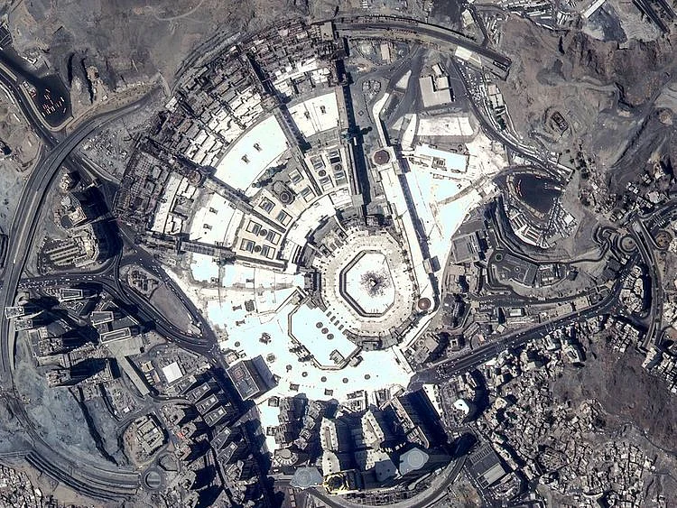
Some of those images included shots of the Palm Jumeirah, Al Nasr Club’s Al Maktoum Stadium, the Kingdom Centre, Masjid Al Haram in Mecca, Al Masjid an-Nabawi, the Federal Territory Mosque in Kuala Lumpur, Malaysia, and the Baikonur Cosmodrome, where the first Emirati astronaut travelled into space last month.
The satellite has also captured images of major projects and achievements in the UAE and its construction work, including Abu Dhabi International Airport and the surrounding areas, in addition to the construction developments around The Louvre Abu Dhabi.
KhalifaSat has played an important role in monitoring environmental changes, ensuring effective urban management, and identifying areas in need during disaster relief efforts.
Yousuf Hamad Al Shaibani, Director General of MBRSC, said, “Today marks one year after the launch of KhalifaSat, the first satellite developed 100 per cent in the UAE by a team of highly qualified Emirati engineers. After the outstanding performance, images and analysis it has provided, we celebrate the culmination of one of the UAE’s major achievements. This success proves that our youth are able to make more achievements, reflecting the aspirations of our wise leadership.
“Day after day, Emirati youth acquire more experience and skills in the space sector, enabling us to strengthen our position in the field of satellite manufacturing and management,” added AlShaibani.
Amer Al Ghafri, Director of Space Systems Development Department and KhalifaSat Project Manager, said, “One year after its launch, KhalifaSat is performing very well. It is still ahead of other satellites in the region, in monitoring and analysis. KhalifaSat will be able to capture more images in the next few years.”
“KhalifaSat was developed 100 per cent by a team of Emirati engineers. In addition, the technical support and updates were also carried out by an Emirati team at MBRSC. KhalifaSat raised the level of national competencies who worked on the project and developed their skills to be able to deal well with all the challenges and difficulties faced by the satellite during its first year,” added Al Ghafri.
What does KhalifaSat do?
KhalifaSat’s mission, since being launched in Japan last year, is to provide detailed images for environmental monitoring, study areas, and urban planning. KhalifaSat also monitors environmental changes, ensures effective urban management, and aids in disaster relief efforts. KhalifaSat is also capable of providing accurate information on the location, direction, and speed of ships. It also provides images monitoring development trends and changes on the planet, especially by government organisations. These images are then used in the design and production of detailed maps of the region.
Advanced technology
Khalifa Sat is the most technologically advanced UAE satellite, orbiting the ground at a height of 580-620-km. The entire cycle around Earth is about 100 minutes, 3.3 meters wide, and the colour engineering accuracy of 0.7 meters and 4 meters of multi-spectral bands, with space speed at a total of 27,000 kilometres per hour. There are also 14 access points for ground stations throughout the world, as well as 4 access points for ground stations throughout the UAE. The speed of data transfer is 320 Mbps, while it’s 87 megabytes per second. It also includes 87 electronic units and 146 structural units. In its first year it has communicated back to the MBRSC ground station 906 times.
KhalifaSat is the first satellite to be developed in the clean rooms of the MBRSC. With five patents, this technological icon was manufactured by a team of Emirati engineers from the MBRSC. The satellite caputures high-quality images that assist governments and private organisations. The initial manufacturing stages were done in South Korea, and then transferred to the Centre. The 100% dust-free laboratories were equipped to complete the manufacturing process.
MBRSC is building and operating Earth observation satellites and providing image and data analysis services to customers around the world. KhalifaSat is the third satellite to be developed by MBRSC after DubaiSat-1 and DubaiSat-2.
Sign up for the Daily Briefing
Get the latest news and updates straight to your inbox
Network Links
GN StoreDownload our app
© Al Nisr Publishing LLC 2026. All rights reserved.