Photo provided by Iranian state broadcaster IRIB allegedly shows a foreign-flagged vessel that ran aground in the Strait of Hormuz on July 1, 2026. No name and location was provided, but IRIB reported the ship ran aground while using a “US-suggested route”.
Iran blames US after ship runs aground in Hormuz. Here's what shipping data shows
Grounded Comoros-flagged ship tied to Iran’s Shamkhani network, not on US route
Last updated:
4 MIN READ
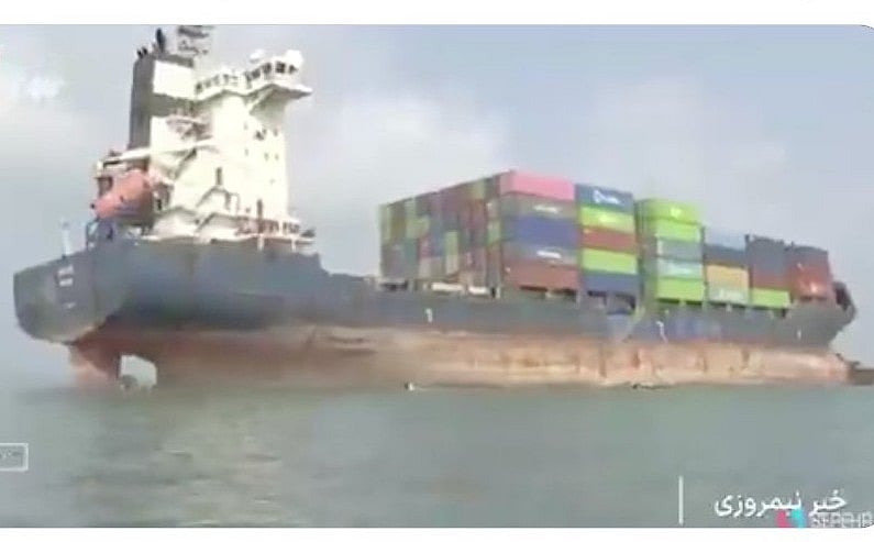
Photo provided by Iranian state broadcaster IRIB allegedly shows a foreign-flagged vessel that ran aground in the Strait of Hormuz on July 1, 2026. IRIB did not mention the ship's name and geolocation, and simply reported that the vessel ran aground while using a “US-suggested route”. Live ship tracking data shows Comoros-flagged Arista was stuck since March in Iranian territorial waters and belongs to a US-sanctioned Shamkhani shipping empire based in Iran.
IRIB
On Wednesday (July 1, 2026) the Islamic Republic of Iran Broadcasting (IRIB) reported that a foreign-flagged “cargo ship attempting to transit the Strait of Hormuz using a US-suggested route” had run aground.
The Tehran-based broadcaster, affiliated with Iran’s Islamic Revolutionary Guard Corps (IRGC), noted that it’s “an incident even worse than sinking”.
Get updated faster and for FREE: Download the Gulf News app now - simply click here
It allegedly took place after the container ship “deviated from the designated shipping route”.
IRIB also highlighted the need to know the “proper depth and length for the passage of a variety of wide-body ships, especially oil tankers”.
The IRGC has repeatedly warned ship captains, owners, and international shipping companies that navigating outside this route could make them a target.
The IRIB report, while directly blaming the US, was apparently aimed to justify IRGC's toll or "service fees" that it seeks to charge ships transitting the narrow waterway shared with Oman.
In its report, IRIB left out the vessel’s geolocation, and suggested the vessel was grounded on July 1, 2026 itself.
What ship trackers say
Shipping data platform TankerTrackers, closely followed by insurers, reported the container ship’s name as “Arista” (IMO 9348493) and also shared its GPS coordinates, based on latest automatic identification system (AIS) data.
It reported that Arista, a Comoros-flagged container ship, ran aground in Iranian territorial waters near Hormuz Island since March 14, 2026.
The data shows the grounded vessel is under US sanctions for being part of the Shamkhani network, and was not following a US-suggested route.
Iranian broadcaster IRIB released a video footage of the foreign cargo ship stuck in the Strait of Hormuz after "attempting to transit using a US-suggested route" on July 1, calling it "an incident even worse than sinking," per IRIB.
Arista had an AIS-reported draft depth of 10 meters ran aground in 35-50 metres of water.
Satellite photos also confirmed its location and speed (0 knots).
The Shamkhani network
Tanker Trackers reported that Arista is a Comoros-flagged but is part of Iran's Shamkhani network, a multibillion-dollar, covert shipping empire led by Mohammad Hossein Shamkhani, which uses a web of global front companies, dozens of vessels, and offshore hedge funds to launder profits from the illicit sale of Iranian and Russian crude oil and liquefied petroleum gas (LPG) to traders in China.
A snapshot taken around 1.10pm GST on Thursday (July 2, 2026) from the live Marine Traffic ship tracking site provides a near real-time view of commercial and maritime traffic in one of the busiest and most strategically significant waterways in the world. It shows the Arista container ship's speed at 0 knots.
Arista has been under US Office of Foreign Assets Control (OFAC) sanctions “since last summer”, Tanker Trackers reported.
The site mentioned the actual date when Arista ran aground.
“She's actually been stuck in this same spot since mid-March 2026; at 27.12845, 56.46221; north of Hormuz Island, Iran,” Tanker Trackers reported.
That location forms part of Iran's territorial waters, which under UNCLOS is defined as a maritime belt extending up to 12 nautical miles from its coastal baseline.
Ship tracking site Marine Traffic, also confirmed Arista’s location as of Thursday (July 2, 2026).
Officially, OFAC lists the container’s ship’s name as GAUJA (IMO 9348493, with call sign 3EKS9), built originally in 2006 and also identified as IRAN-EO13902, which was originally Panama-flagged.
Marine Traffic’s open-source live vessel-tracking platform shows that Arista is currently stationary (0 knots, heading 0°) with its reported destination listed as Asaluyeh, Iran.
Its latest AIS (Automatic Identification System) position was received four minutes before the screenshot (taken around 2.10pm GST).
The map centres on the waters between Qeshm Island (Iran) and the Musandam Peninsula (Oman), near the entrance to the Arabian Gulf.
It tracks maritime activity in and around the Strait of Hormuz, one of the world's most strategically important shipping corridors.
The numerous coloured symbols represent different classes and statuses of vessels transmitting AIS signals.
Marine Traffic stated that the vessel's destination, Asaluyeh, is one of Iran's most important energy and industrial hubs on the Arabian Gulf coast.
It hosts facilities supporting the South Pars gas field, the world's largest natural gas field, and receives regular traffic from tankers, LNG-related vessels, supply ships, and other commercial maritime traffic.
A substantial share of the world's seaborne crude oil and liquefied natural gas (LNG) passes through this chokepoint.
Because this region is geopolitically sensitive, vessel movements are often monitored closely by governments, shipping companies, insurers, and analysts.
Automatic Identification System (AIS): It is an automated tracking and communication system used on boats, ships, and by coastal authorities to enhance safety, avoid collisions, and monitor global marine traffic. AIS uses VHF radio waves to automatically transmit and exchange vital navigational data between vessels, satellites, and shore stations. The system combines a built-in GPS (for location) with a VHF radio transmitter to continuously broadcast and receive the following details
Under Iran's navigation system, vessels that coordinate their transit with the IRGC Navy – which can mean paying tolls or service fees – are provided with scheduled passage and security escort from the time they enter the Persian Gulf until they exit, Iranian officials have said.
Last week Oman and the UN’s International Maritime Organisation announced that a new route, closer to its coastline, was open for transit, which Iran swiftly denounced.
Network Links
GN StoreAbout Gulf NewsTerms & ConditionsReach by GNSitemapContact usPrivacy PolicyGN FocusHave your sayWork with usAdvertise with usGulf News epaperPrinting Services
Download our app
© Al Nisr Publishing LLC 2026. All rights reserved.