This frame grab made from UGC video footage courtesy of Deped Mahayahay Elementary School shows huddled schoolchildren in a field reacting during an 7.8 magnitude earthquake in Malita town, Davao del Sur province on June 8, 2026.
Philippines earthquake death toll rises to 35 after landslide in South
Tremors trigger landslide in southern Philippines
Last updated:
2 MIN READ
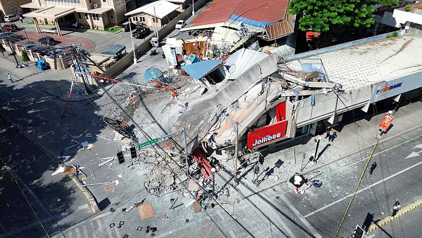
A drone view shows a collapsed building after a magnitude 7.8 quake in General Santos, Mindanao Island, Philippines, June 8, 2026.
GenSan DEV
Manila: The death toll from a powerful magnitude 7.8 earthquake in the Philippines on Monday has risen to at least 35, officials said Tuesday (June 9), as search-and-rescue teams battled landslides, collapsed roads and aftershocks across the country’s southern region.
At least 17 of the fatalities were reported in a mountainous province in southern Philippines, where a massive landslide triggered by the quake buried homes and cut off several rural villages, according to the National Disaster Risk Reduction and Management Council (NDRRMC).
Emergency crews said access to some affected areas remained extremely difficult due to blocked highways and unstable slopes.
Violent tremors
The Philippine Institute of Volcanology and Seismology (Phivolcs) said the quake struck at a shallow depth, amplifying surface shaking across wide areas of Mindanao and nearby islands.
Residents reported violent tremors that lasted several seconds, sending people fleeing into streets and open fields as buildings swayed and power lines snapped.
Authorities warned that the casualty count could still rise as communication lines are restored and remote areas are reached. Dozens of aftershocks have been recorded since the main quake, complicating rescue operations and raising fears of additional landslides.
The Office of Civil Defense (OCD) said military units and disaster response teams have been deployed to assist with evacuation, debris clearing and emergency medical aid.
Temporary shelters
Temporary shelters have been set up for displaced residents, many of whom lost homes in the quake and subsequent slope collapses.
President Ferdinand Marcos Jr. expressed condolences to victims’ families and ordered government agencies to prioritize relief operations, according to Malacañang.
He also directed officials to assess infrastructure damage, including bridges, schools and hospitals in affected provinces.
The Philippines sits along the Pacific “Ring of Fire,” a seismically active zone where earthquakes and volcanic eruptions are common. The country experiences hundreds of quakes each year, though most are too weak to be felt.
Secondary disasters
Experts say earthquakes of this magnitude in the region often cause secondary disasters — especially landslides in mountainous, rain-saturated terrain.
The southern Philippines is particularly vulnerable due to steep slopes, deforested areas and scattered rural settlements with limited road access.
Disaster officials noted that while building codes have improved in urban centers, enforcement remains uneven in remote provinces, increasing risk during strong quakes.
Fact file
Magnitude: 7.8
Death toll: At least 35 (NDRRMC)
Injuries: Not yet fully confirmed
Hardest-hit area: Southern Philippines (landslide zone)
Primary hazards: Landslides, aftershocks, infrastructure collapse
Response agencies: NDRRMC, OCD, Armed Forces of the Philippines, Phivolcs
Geological setting: "Pacific Ring of Fire"
Ongoing risk: Aftershocks and secondary landslides
Sign up for the Daily Briefing
Get the latest news and updates straight to your inbox
Network Links
GN StoreAbout Gulf NewsTerms & ConditionsReach by GNSitemapContact usPrivacy PolicyGN FocusHave your sayWork with usAdvertise with usGulf News epaperPrinting Services
Download our app
© Al Nisr Publishing LLC 2026. All rights reserved.