Monster typhoon Bavi roars toward Philippines with 200-km/h winds
Storm could reach 'super typhoon' strength, bringing destructive winds and surge
Manila: Typhoon Bavi strengthened over the Philippine Sea as forecasters warned the storm could rapidly intensify while tracking toward the Mariana Islands, including the US territory of Guam.
Packing sustained winds of up to 200 km (124 miles) per hour, Bavi has reached the equivalent of a Category 1 hurricane on the Saffir-Simpson scale and is moving northwest over exceptionally warm ocean waters.
This weather pattern is expected to fuel Bavi's further strengthening in the coming days.
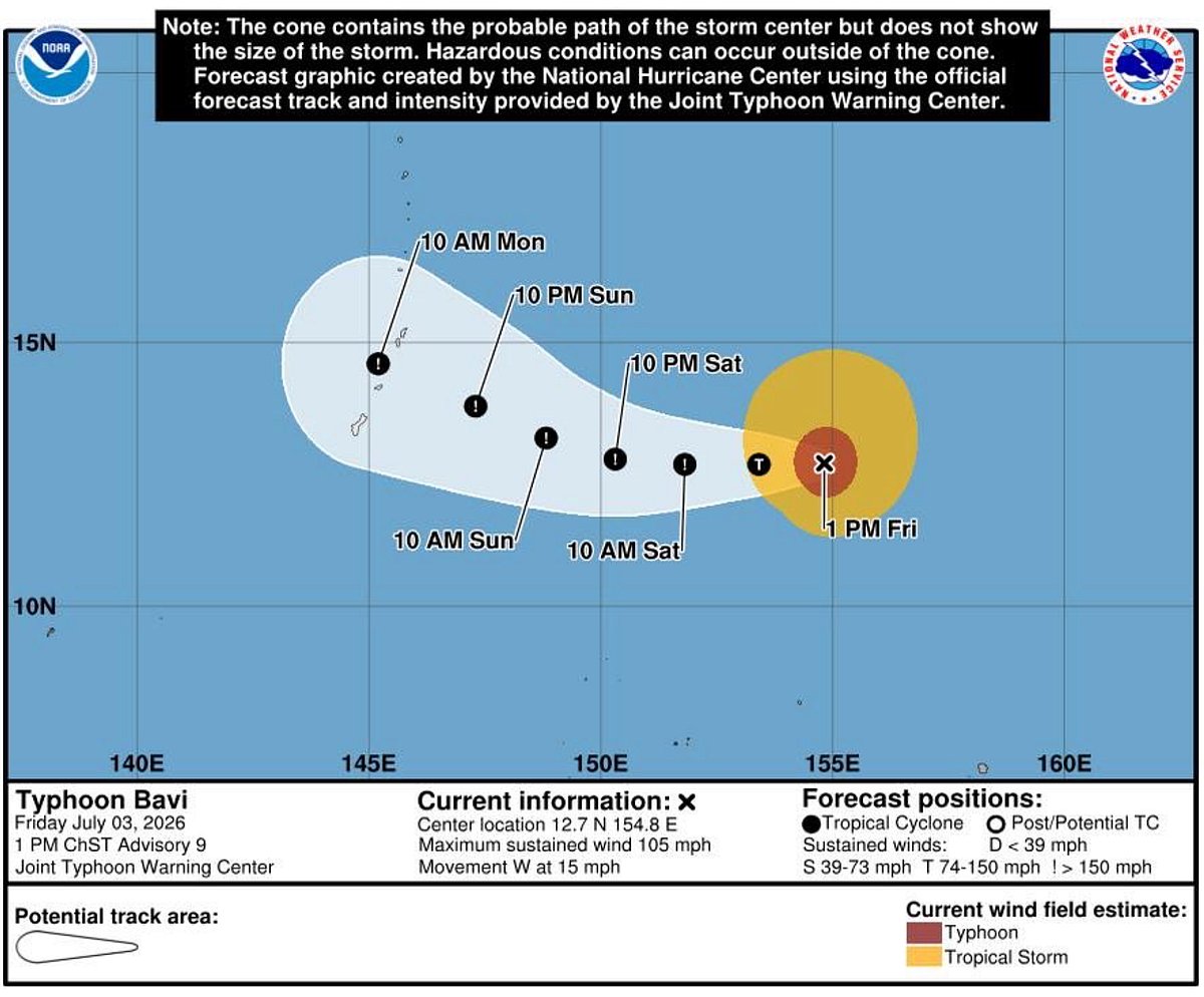
At 1 pm ChST on Friday, the storm's centre was located near 12.7 degrees north latitude and 154.8 degrees east longitude, about 760 miles east of Guam.
Tracking Bavi's course
Bavi was moving west at 15 mph and was expected to maintain a general westward course with a decrease in forward speed through the weekend.
The National Weather Service (NWS) in Guam and the Joint Typhoon Warning Center (JTWC) reported rapid intensification is likely in the coming days, with the system potentially reaching super typhoon status — equivalent to a Category 4 or 5 hurricane — before impacting the region.
Meteorologists said the storm remains over open waters east of the Philippines, but it is forecast to pass near or over parts of the Mariana Islands before curving farther into the western Pacific.
Forecasts indicate tropical storm-force winds could begin affecting parts of the Marianas late Sunday, escalating to typhoon-force winds (74 mph or greater) by Monday, particularly near Tinian and Saipan, though the track could shift and bring impacts closer to Guam.
El Nino driven
While the system is not expected to make landfall in the Philippines in the immediate term, it is being closely monitored because of its potential to alter weather conditions over the country's eastern seaboard.
Weathermen said Typhoon Bavi is moving through an environment "highly favourable for intensification", with unusually warm sea surface temperatures and low vertical wind shear providing ideal conditions for the cyclone to gain strength.
Increasing wind threats
A wind timeline graphic from NWS Guam shows increasing wind threats: green (less than 39 mph) through much of the weekend transitioning to yellow (tropical storm) and red (typhoon) zones for Rota, Tinian and Saipan into early next week.
The Mariana Islands, which include Guam and the Commonwealth of the Northern Mariana Islands (CNMI), are frequently exposed to powerful tropical cyclones during the western Pacific typhoon season.
Local authorities typically begin preparations several days before a storm's closest approach as forecasts become more certain.
Weather agencies continue to monitor Bavi's track and intensity, warning that forecasts could change as the storm evolves.
Residents in Guam and the Northern Mariana Islands have been advised to follow official weather bulletins and prepare for the possibility of hazardous conditions if the typhoon continues to strengthen.
Officials, including the US Coast Guard, have stressed the importance of emergency kits, securing property and heeding local advisories amid expected widespread impacts to infrastructure, power and water systems.
Bavi is the latest in a series of tropical systems to threaten the western Pacific this season. Conditions are expected to remain relatively fair through Saturday before deteriorating.
Network Links
GN StoreDownload our app
© Al Nisr Publishing LLC 2026. All rights reserved.