New tropical depression 'Wilma' seen east of the Philippines, landfall expected on Dec. 5 (Friday)
Weather system has high likelihood of developing from LPA > tropical depression > typhoon
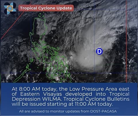
Manila: A low-pressure area in the western Pacific off the Philippines' east has turned into a "tropical depression" inside the Philippine Area of Responsibility (PAR) as of 8 am on Thursday (Dec. 4, 2025), weathermen reported.
The LPA was initially seen forming on Monday afternoon, December 1, positioned just outside PAR.
It was seen moving west on Tuesday (December 2), during which the Philippine Atmospheric, Geophysical and Astronomical Services Administration (Pagasa) said the weather system has a "high likelihood" of developing into a tropical depression within the next 24 to 48 hours.
'Bagyo'
On Wednesday (December 3), the LPA was expected to become a "bagyo" named “Wilma” as it enters PAR.
Storm trackers expect Wilma to hit land in Eastern Visayas or the Bicol region around December 5, 2025 or over the weekend, though its exact path is uncertain.
Uncertainty
Weather specialist Chenel Dominguez said that forecast models suggest the system could potentially make landfall in Eastern Visayas or Caraga, but there remains significant uncertainty about its exact track.


Currently, the LPA is not yet affecting weather in the country.
Localised rains, thunderstorms
However, localised rains and thunderstorms may still occur over southern Mindanao due to the Intertropical Convergence Zone (ITCZ) and over northern Luzon driven by the northeast monsoon or amihan, the weather bureau Pagasa stated Tuesday.
Pagasa indicated that rains could begin impacting the Bicol Region, Eastern Visayas, and Mindanao by Friday and persist through the weekend, with the system expected to move across the Visayas after initial landfall.
Earlier report:
Low-pressure area
As of 5 am on Tuesday, December 2, the LPA was located approximately 1,280 km east of Eastern Visayas.
Once the system enters the PAR as a tropical cyclone, it will be named "Wilma."
Meanwhile, Pagasa warns that one to two tropical cyclones may still develop or enter the PAR this December.
Weather specialist Leanne Loreto noted that historically, tropical cyclones forming in December tend to be "landfalling," i.e. passing directly over land, usually affecting Visayas, southern Luzon, and northern and eastern Mindanao with strong winds and heavy rains.


