Philippines earthquake: Cebu fault 'last moved 400 years ago'. Here's why the country is prone to tremors
Fault that triggered the magnitude 6.9 quake on Tuesday night last moved 4 centuries ago
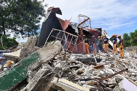
Manila: The Cebu fault that triggered the deadly earthquake in central Philippine islands on Tuesday night (September 30) "last moved 400 years ago", government experts said.


"At least in the last 400 years, 'yung fault na nag-generate dito, ngayon lang siya ulit gumalaw. Medyo matagal po siya gumalaw kaya siya medyo malakas (the fault that generated this, it's only now that it moved again. It took some time before it happened again, that's why it's a bit strong)," Phivolcs told local media.
Why is the country frequented by earthquakes and volcanic eruptions?
The Philippines is prone to natural disasters and is located on the seismically active Pacific "Ring of Fire", a band of volcanoes and fault lines that arcs round the edge of the Pacific Ocean.
Earthquakes are frequent here, and so are volcanic eruptions.
The Philippines experiences frequent earthquakes primarily due to its location along several active tectonic boundaries and fault zones.
Pacific 'Ring of Fire'
Most notably, it lies along the Pacific Ring of Fire, a horseshoe-shaped zone in the Pacific Ocean basin characterised by intense seismic and volcanic activity.
The Pacific Ring of Fire is a major area in the basin of the Pacific Ocean where many earthquakes and volcanic eruptions occur.
It is shaped roughly like a horseshoe and extends about 40,000 km (25,000 miles) around the Pacific Ocean.
90% of earthquakes
It is responsible for about 75% of the world's active and dormant volcanoes and about 90% of the world’s earthquakes, due to the movement and collision of multiple tectonic plates in that region.
Top 10 tremors in the last 500 years
Here is a list of the top 10 most powerful earthquakes affecting the Philippines over the past 500 years (with dates, estimated damage):
1645 Luzon Earthquake – Estimated magnitude 7.5–8.0; devastated parts of Luzon with significant casualties.
1863 Manila Earthquake – Magnitude around 6.3; caused major damage in Manila city.
1880 Luzon Earthquake – Estimated magnitude 7.7; extensively damaged buildings in Manila.
1918 Celebes Sea Earthquake – Magnitude 8.3; strong shaking felt in Mindanao region.
1976 Moro Gulf Earthquake – Magnitude 8.0; triggered a deadly tsunami, causing over 8,000 deaths in Mindanao.
1990 Luzon Earthquake – Magnitude 7.7; killed nearly 1,600 people and caused widespread destruction in northern Luzon and Baguio City.
2012 Negros Earthquake – Magnitude 6.7; caused numerous casualties and structural damage.
2019 Cotabato Earthquake – Magnitude 6.6–6.8 (series); caused deaths and destruction in Mindanao.
2023 Mindoro Earthquake – Magnitude 7.0; caused damage in southwestern Luzon.
2023 Philippine Trench Earthquake – Magnitude 7.6; significant shaking in Luzon and surrounding areas.


