A security guard walks past a damaged wall and a car outside a mall in Butuan City, on the southern island of Mindanao on October 10, 2025, after a 7.4-magnitude earthquake struck off the southern Philippines.
UPDATE
7.4-magnitude quake hits southern Philippines, 2 dead, evacuations ordered
Tsunami alert lifted for Philippines, Palau, Indonesia after quake
Last updated:
3 MIN READ
Philippine seismologists say an offshore earthquake with a preliminary magnitude of 7.6 has hit off a southern province 7.6-magnitude earth. A tsunami warning has been raised in the area.
A 7.4-magnitude earthquake Friday morning off the southern Philippines damaged buildings, knocked out power, killed at least two people and prompted evacuations of coastal areas nearby due to a possible tsunami.
President Ferdinand Marcos Jr. said the potential damage was being assessed and rescue teams and relief operations were being prepared and would be deployed when it was safe to do so.
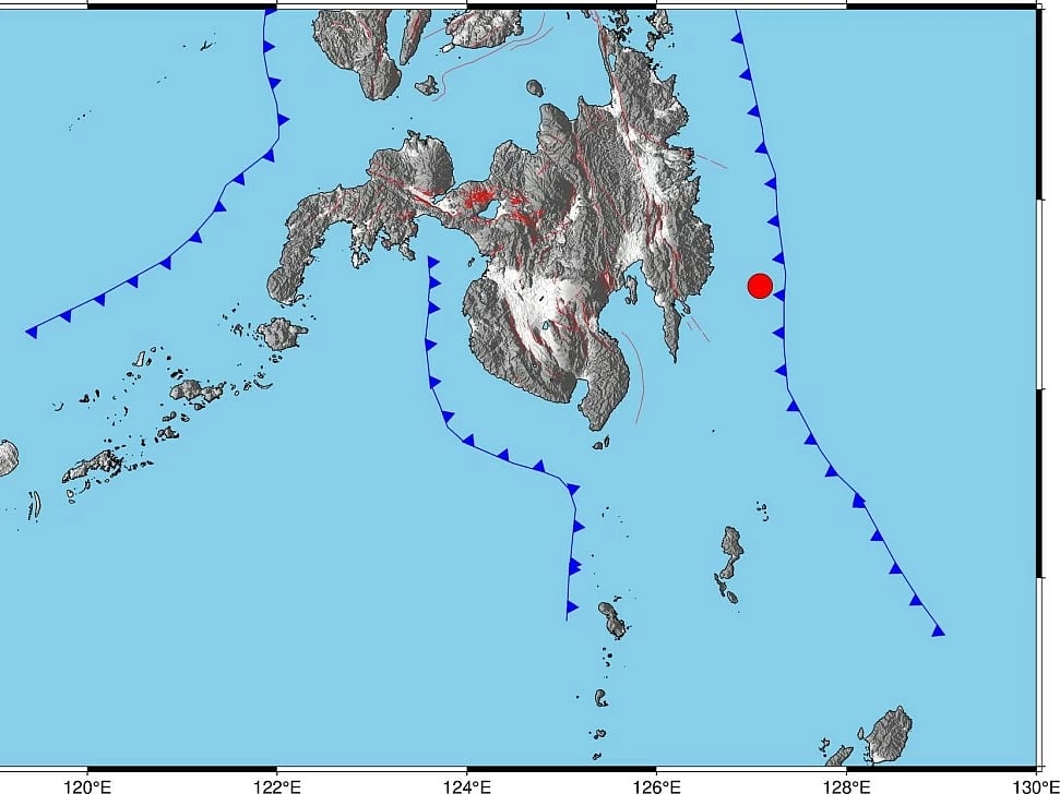
The Philippine Institute of Volcanology and Seismology (Phivolcs) said it was expecting damage and aftershocks from the earthquake, which was centred at sea about 62 kilometers (38 miles) southeast of Manay town in Davao Oriental province and was caused by the movement in the Philippine Trench at a depth of 23 kilometers (14 miles).
At least one person died after being hit by falling debris in the south, Office of Civil Defense deputy administrator Bernardo Rafaelito Alejandro IV said in a news briefing without providing details.
Several buildings sustained cracks in their walls, including an international airport in Davao city, but it remained operational without any flights being cancelled, Alejandro said.
The Pacific Tsunami Warning Center in Honolulu said hazardous waves were possible within 300 kilometers (186 miles) of the epicenter. There was not a wider danger of a tsunami, it said.
The earthquake’s initial magnitude was stated at 7.6, then the Philippine Institute of Volcanology and Seismology (Phivolcs), later downgraded it to 7.5, while USGS stated the quake's magnitude at 7.4.
Initial images and videos of the damage have emerged, though independent verification is not available at the moment.
The tremors were also felt in Davao City (Intensity 5), and in Bislig City, Surigao del Sur (Intensity 4).
Other areas of Mindanao mainland, such as Bukidnon and Cagayan de Oro City, and parts of the Visayas, also felt the earth move.
Mindanao is a mineral-rich island, with a land area more than thrice the size of Belgium.
In the province of Cebu City, still reeling from the magnitude 6.9 jolt on September 30, with Bogo City as the epicentre, recorded Intensity 4 tremors.
Tsunami warning
Immediately after Friday’s tremor, Phivolcs issued a tsunami warning for the following provinces:
Davao Oriental
Dinagat Islands
Surigao del Norte
Surigao del Sur
Eastern Samar
Southern Leyte, and
Leyte.
The agency said the first tsunami waves may arrive between 9:43 am and 11:43 am, and the waves may continue for hours.
Wave heights of “more than 1 meter above the normal tides” are expected.
Phivolcs urged coastal area residents of affected provinces to “immediately evacuate to higher grounds or move farther inland.”
“Owners of boats in harbours, estuaries, or shallow coastal water…should secure their boats and move away from the waterfront. Boats already at sea during this period should stay offshore in deep waters until further advised,” added the agency.
Tectonic
Phivolcs reported that the quake’s epicentre was located 62 kilometers southeast of Manay, Davao Oriental, at a depth of 10 kilometers.
The tremor was tectonic in origin, meaning it was triggered by the movement of an active fault in the area.
The agency said intensity reports were not yet available in its initial bulletin and cautioned the public about possible damage and aftershocks following the strong quake.
Evacuations and emergency response
President Ferdinand Marcos Jr. said authorities are assessing potential damage and preparing rescue and relief operations that will be deployed when it is safe.
Children were evacuated from schools in Davao City, the largest city near the epicenter with about 5.4 million residents, located roughly 250 kilometers (155 miles) west of Davao Oriental province.
The Philippine Institute of Volcanology and Seismology reported the quake originated at sea, about 62 kilometers (38 miles) southeast of Manay town in Davao Oriental, caused by movement along a fault at a shallow depth of 10 kilometers (6 miles). Authorities expect aftershocks and potential damage in the affected areas.
Regional alerts
Indonesian authorities issued a tsunami warning for northeastern Papua and North Sulawesi, about 275 kilometers (170 miles) from the epicenter.
The Meteorology, Climatology, and Geophysics Agency cautioned residents to stay away from beaches and riverbanks.
Philippines’ vulnerability to disasters
The Philippines is still recovering from a 6.9-magnitude earthquake on Sept. 30, which killed at least 74 people and displaced thousands in Cebu province, especially Bogo City.
Located on the Pacific “Ring of Fire”, the Philippines is highly prone to earthquakes and volcanic eruptions. It also faces around 20 typhoons annually, making disaster response a critical responsibility for government and volunteer groups.
Sign up for the Daily Briefing
Get the latest news and updates straight to your inbox
Network Links
GN StoreAbout Gulf NewsTerms & ConditionsReach by GNSitemapContact usPrivacy PolicyGN FocusHave your sayWork with usAdvertise with usGulf News epaperPrinting Services
Download our app
© Al Nisr Publishing LLC 2026. All rights reserved.