Philippines: New typhoon threatens northern Luzon
Fresh alert up as tropical storm Kong-rey, locally named Leon, intensifies
Manila: The Philippines, still recovering from the impacts of the deadly Tropical Storm Trami, is now bracing for Severe Tropical Storm Kong-rey (locally named "Leon"), which intensified overnight.
According to the state weather bureau Pagasa, 12 provinces in Luzon are currently under Wind Signal No. 1 as Kong-rey approaches.
As of October 27, Trami left 110 people dead and displaced more than 575,000 people.
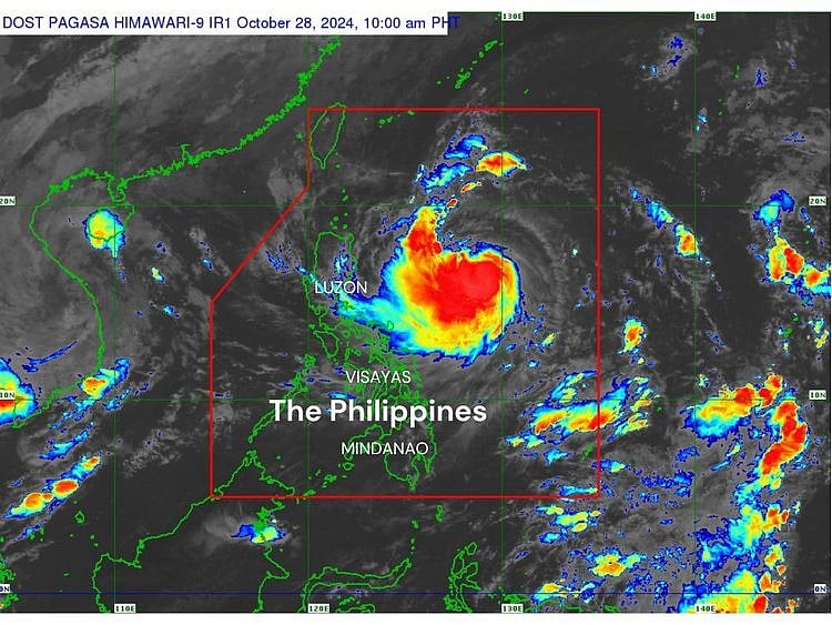
As of 10 am on Monday (October 28, 2024), the centre of Kong-rey was located approximately 735 km east of Casiguran, Aurora, or 780 km east of Echague, Isabela.
Moving westward
The storm is moving westward at 20 kph, carrying maximum sustained winds of 95 kph and gusts reaching up to 115 kph.
The following provinces are currently under Tropical Cyclone Wind Signal No. 1:
Pagasa weathermen have issued a gale warning over the northern and eastern seaboards of Northern Luzon for Monday afternoon.
The storm’s trough and rainbands may bring moderate to intense rainfall over Northern and Central Luzon, Calabarzon, Mimaropa, and Western Visayas, with the potential for flooding and landslides in affected areas.
'Typhoon status within 24 hours'
Pagasa forecasts that Kong-rey will continue to strengthen rapidly over the Philippine Sea, possibly reaching typhoon status within 24 hours and may even intensify to super typhoon level as it nears Batanes.
The storm is expected to track west-northwestward on Monday and Tuesday before shifting northwestward. It is anticipated to make landfall along Taiwan's eastern coast by Thursday night or early Friday.
Following its passage over Taiwan, Kong-rey is projected to turn northeastward, exiting the Philippine Area of Responsibility by Friday morning or afternoon.
Sign up for the Daily Briefing
Get the latest news and updates straight to your inbox
Network Links
GN StoreDownload our app
© Al Nisr Publishing LLC 2026. All rights reserved.