Philippines: Monster storm ‘Pepito’ set to strike Visayas, mainland Luzon
'Move to safer ground', flood-prone residents told, as storm parade batters country

Manila: The Philippines is currently being hammered by a super typhoon, with another possible hit this weekend.
That's six tropical cyclones in less than two months, an unprecedented rate since monitoring began in 1951.
As the powerful Typhoon "Pepito" (international code: Man-Yi) barrels toward the Philippines — residents in flood-prone areas are urged to evacuate immediately.
The monster storm threatens widespread devastation, and authorities warn that staying behind could mean facing its full fury. Residents in low-lying areas are urged to take refuge in the nearest evacuation centres before it's too late.
The warning came as the Philippines still reels from the effects of a parade of storms.
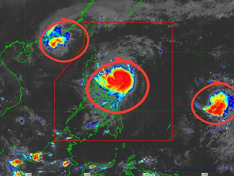
On Thursday (November 14), while supertyphoon Ofel (international code: “Usagi”) is pummelling northern Philippines, Pepito has been seen moving westward on the Pacific basin.
Pagasa’s latest update shows Pepito entered PAR at 8pm on Thursday. Heavy to intense rain (100-200 mm) is expected in Northern Samar, Eastern Samar, and Sorsogon provincse from Friday (November 15) evening to Saturday evening (November 16).
Moderate to heavy (50-100 mm) rain is also expected in Batanes, Camarines Norte, Camarines Sur, Albay, Catanduanes, Leyte, Biliran, and Samar provinces.
Ofel's maximum sustained winds of 120 kph, with gusts up to 150 kph, brought heavy rainfall to Isabela, Cagayan, and Catanduanes. Potential hazards include landslides and flooding, particularly in Northern and Central Luzon, with storm surges of up to 3 metres in coastal areas, including Batanes, Ilocos Norte, Cagayan, and northern Aurora.
Evacuation
Meanwhile, emergency workers are prepositioning provisions for search and rescue operations, and support for potential evacuees as Pepito is expected to make a direct hit on the major islands of Visayas and Luzon.
Storm Ofel is following swiftly after Typhoon Marce (Yinxing), which recently hammered northern Philippines with severe floods and landslides. The intense weather forced the closure of two major airports, disrupting flights and travel before Marce finally moved away from the region.
Damage from the storms so far this 2024 has been primarily due to severe tropical storm “Enteng” (or Yagi) and “Kristine” (Trami) “Leon” (Kong-Rey) and “Nika” (Toraji).
The latest bulletin from Pagasa warns of significant rainfall across the Philippines due to the combined effects of Tropical Cyclones Ofel and Man-Yi.
Here’s the expected rainfall distribution:
Today (Nov. 14) to tomorrow (Nov. 15)
Intense to Torrential Rain (>200 mm):
Cagayan and Isabela
Heavy to Intense Rain (100-200 mm):
Batanes, Ilocos Norte, Apayao, Mountain Province, Quirino, Aurora, Kalinga
Moderate to Heavy Rain (50-100 mm):
Abra, Ifugao, Nueva Vizcaya
Friday noon to Saturday noon (Nov. 15-16)
Heavy to Intense Rain (100-200 mm):
Batanes, Northern Samar, Eastern Samar, Sorsogon
Moderate to Heavy Rain (50-100 mm):
Babuyan Islands, Camarines Norte, Camarines Sur, Albay, Catanduanes, Leyte, Biliran, Samar
Saturday noon to Sunday noon (Nov 16-17)
Intense to Torrential Rain (>200 mm):
Quezon, Camarines Norte, Camarines Sur
Heavy to Intense Rain (100-200 mm):
Northern Samar, Albay, Catanduanes, Sorsogon, Marinduque, Cavite, Laguna, Rizal, Metro Manila, Central Luzon provinces
Moderate to Heavy Rain (50-100 mm):
Leyte, Masbate, Eastern Samar, Pangasinan, Romblon, Biliran, Quirino
Key warnings:
Deadly storms
Since September 2024, the Philippines, and the western Pacific basin has seen a succession of deadly and costly storms.
On the night of November 15, 2024 weather bureau Pagasa predicts that the eye of Pepito will be over Northern Samar before it ploughs through the Bicol peninsula before it hits the agro-industrial areas of Calabarzon, and the capital Manila (National Capital Region).
The Philippines, situated in the west Pacific, has seen a close succession of deadly and costly typhoons this year. Already, this year is proving to be the most active typhoon season since 2019 – and the most damaging since 2013 (Haiyan, locally known as “Yolanda”), according to weathermen.
On November 7, 2013, Haiyan (known locally as Yolanda) made landfall in Eastern Samar at peak intensity. The JTWC's unofficial estimate of one-minute sustained winds of 305 km/h (190 mph) would, by that measure, make Haiyan the most powerful storm ever recorded to strike land. This record was later broken by Typhoon Goni in 2020.
How typhoons are named:
In the northwestern Pacific, two agencies assign names to tropical cyclones, sometimes leading to dual names for a single storm:
Morever, the US Joint Typhoon Warning Center (JTWC) designates tropical depressions with a number followed by the suffix "W" (indicating the western Pacific region).
Sign up for the Daily Briefing
Get the latest news and updates straight to your inbox
Network Links
GN StoreDownload our app
© Al Nisr Publishing LLC 2026. All rights reserved.