A person shovels snow outside Rome Grocery northeast of Bellingham, Washington. Heavy snow, freezing rain and sleet have disrupted travel across the Pacific Northwest, causing widespread flight cancellations and creating hazardous driving conditions.
Winter snow rattling busy US travel season with cold and snow: Here's what to expect
The Christmas weekend could be the coldest in decades
Last updated:
9 MIN READ
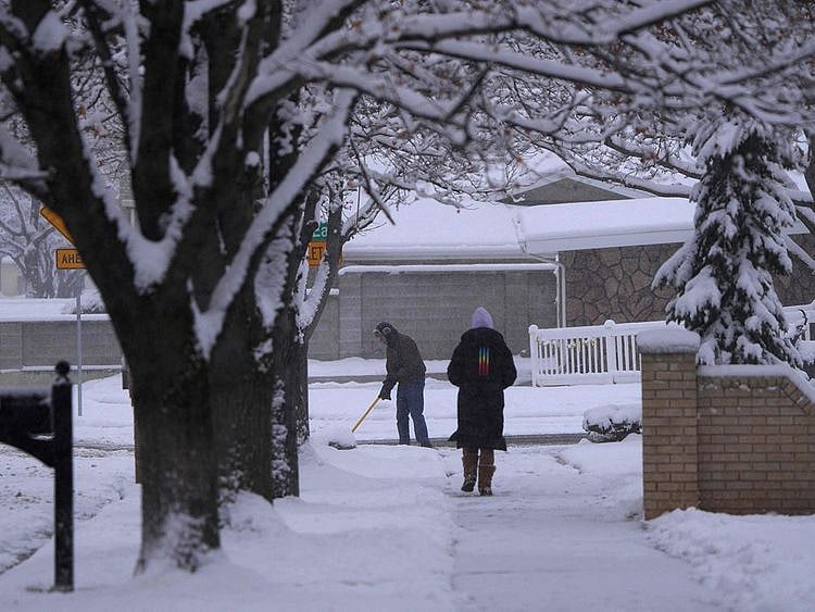
A man clears his driveway of snow as a woman walks down the sidewalk after an overnight storm in Provo,Utah on December 13, 2022.
AP
A massive winter storm is winding across the central US, threatening to disrupt air traffic during the busy holiday season, rake Chicago with a blizzard and send an arctic blast as far south as Texas and the Gulf of Mexico.
Wind chill watches and warnings stretch from Montana to Alabama, and Chicago could get 8 inches (20 centimeters) of snow driven by 55-mile- (89 kilometer) per-hour winds, setting up a blizzard there and across the region, the National Weather Service said. The wild weather in one of the largest US air hubs will almost certainly delay and cancel flights across the country. The cold will then push east, bringing heavy snow to the eastern shores of Lake Erie and Lake Ontario.
An estimated 112.7 million people will travel 50 miles or more from December 23 to Jan. 2, up by 3.6 million from last year and getting close to pre-pandemic levels, according to AAA, a provider of travel insurance.
"It's going to be a pretty impactful storm coming across a huge part of the country," said Bob Oravec, a senior branch forecaster for the US Weather Prediction Center.
Flight cancellations
An early sign of trouble came Tuesday in Seattle, where a winter storm caused at least 192 flight cancellations, according to the FlightAware tracking service. Greyhound also cancelled bus service between Seattle and Spokane. Airlines offered travellers the option of choosing new flights to avoid the bad weather. Delta, American, United and Southwest waived change fees at airports that might be affected. The Transportation Safety Administration expected Dec. 22 and Dec. 30 to be the busiest days at US airports, with traffic expected to be close to pre-pandemic levels. Airports said they would work hard to stay open. Chicago’s O’Hare and Midway airports said they have 350 pieces of equipment and 400,000 gallons of pavement de-icing fluid between them to keep runways and taxiways clear. The weather added uncertainty to what was expected to be a busy travel season. Earlier this month, AAA estimated that nearly 113 million people would travel 50 miles from home or more between Dec. 23 and Jan. 2. That’s 4% higher than last year, although still short of the record 119 million in 2019.
In addition to the travel disruptions, arctic cold will sweep down the Great Plains as far as Texas and the Gulf Coast, boosting demand for electricity and natural gas as people crank their thermostats. The weather will be a test for the Texas electric grid, which buckled under an even more frigid snap in February 2021, though this time it's not expected to last as long. Temperatures should start to moderate by the weekend.
But people will notice the wild swing in temperatures. Houston will start Thursday with a high of 65 F (18 C) before dropping to an overnight low of 18, according to the weather service. In Denver, Wednesday's high temperature will be 50 F and will only reach 1 F on Thursday. Officials in both cities have opened warming shelters.
Along with the cold will come high winds, which will make temperatures feel even worse in many areas. Windchills across North Dakota may feel as cold as minus 55 F through Saturday. The high winds and snow could also touch off widespread power outages.
"The cold air just rockets southward across the plains," Oravec said. "The arctic front itself is tremendously strong."
For New York, Washington and the other large cities in the Northeast, the main threat will be rain and wind, Oravec said. Temperatures will drop late Friday in New York, but there will likely be just a few flurries.
The front and buffeting winds may still make travel difficult at eastern airports, he said. "Taking off and landing will be bumpy."
The worst of the weather will break for most people as the Christmas holiday arrives and temperatures should start to moderate next week. There doesn't appear to be much of a threat for major cold and snow for the rest of 2022.
Thunder, hail and power outages
A strong winter storm downed trees, knocked out power and flooded soccer fields as it moved across the Hawaiian Islands. Snow fell on the Big Island's tallest peaks.
National Weather Service meteorologist Scott Rozanski said that the weather is typical of the kind of storm Hawaii occasionally gets in December and January. He called these storms “infrequent but not unusual.”
The cold front came in from the northwest, delivering thunderstorms, powerful wind gusts and high surf. Some residents reported pea-sized hail, which Rozanski said was to be expected during a storm of this kind.
Honolulu received dozens of calls about downed trees and branches. The county's parks department closed Waipio's soccer fields because they were saturated.
A power outage forced the closure of the Wailuku courthouse. That prompted Hawaii Chief Justice Mark Recktenwald to order the rescheduling of hearings, trials and filing deadlines on Maui.
Talmadge Magno, the director of Hawaii County Civil Defense Agency, said that downed trees and flooding have blocked some roads.
Snow fell on Mauna Kea and Mauna Loa, including where a vent was spewing lava only a few weeks ago as Mauna Loa erupted for the first time in 38 years . Winter snow on these mountains is not uncommon at high elevations. Mauna Kea rises to 13,803 feet (4,207 meters), and Mauna Loa is 13,679 feet (4,169 m).
The storm was still battering the Big Island as it moved east on Tuesday. Magno said his agency expects to report the extent of the storm damage to the Hawaii Emergency Management Agency on Friday.
The cold front is separate from another storm that started hitting the Pacific Northwest on Tuesday and that's expected to move to the northern Rockies, Plains and Midwest.
Here are the forecasts for 10 cities in the path of Christmas week blizzard
Minneapolis
The Twin Cities are under winter storm watch Wednesday through Friday night, for potential blizzard conditions. A wind chill watch is also up Thursday night through Friday night. Snowfall accumulation of 5 to 10 inches is anticipated.
Fluffy snow begins Wednesday and lasts into Thursday, with blizzard conditions developing Thursday and peaking Thursday night into Friday. Gusts of 45 to 55 mph are possible. Blizzard conditions persist after snow ends. By Thursday, highs aren't far from zero and lows are about minus-5. Dangerous wind chills of minus-25 to minus-40 are a threat Thursday to Friday night.
"Travel conditions could become life-threatening Thursday through Friday night," the Weather Service office serving the Twin Cities wrote.
Des Moines
A winter storm watch is in effect Wednesday evening through Friday night. About 3 to 6 inches are expected in the city, with more to the north.
Snow gets underway late Wednesday and persists into Thursday. Blizzard conditions are possible through Friday night, with wind gusts of 40 to 50 mph forecast. Thursday highs around 10 drop to near zero Friday. Overnight temperatures are near minus-10, with wind chills as cold as minus-20 to minus-40.
"Given the gusty winds, blowing snow, and bitter cold, travel Thursday and Friday will be dangerous and perhaps impossible at times," the Weather Service office serving Des Moines wrote. "Motorists that become stranded would be in great danger given the extreme cold, and travel during this period is highly discouraged."
Kansas City, Mo.
Winter storm watches are up for Thursday morning through Friday afternoon. A wind chill watch is out Thursday afternoon through Saturday morning. The storm will just be developing as it sweeps across the area, so totals are uncertain, but 2 to 4 inches are presently projected.
Wind gusts of 45 to 50 mph combined with Thursday night temperatures near minus-10 lead to wind chills around minus-35. Thursday's high is near 20 and Friday's is around zero as gusty winds persist.
St. Louis
A winter storm watch is in effect from Thursday morning through Friday afternoon. A wind chill watch is up Thursday evening through Saturday morning. One to 3 inches of snow is forecast in the city, with heavier totals to the north, although even minor amounts may lead to dangerous conditions.
Rain and snow chances rise after midnight Wednesday night, with a mix turning to snow likely Thursday and potentially into Thursday night. Thursday highs in the mid-30s are in the mid-20s by sunset, with an overnight low around zero. Friday highs are in the single digits, with wind chills as low as 30 below zero.
"Confidence is high that dangerous wind chills will occur Thursday evening through Saturday from a combination of strong winds and very cold temperatures," the Weather Service office serving St. Louis wrote.Chicago
The Windy City is under a winter storm watch from Thursday evening through Friday night. Snow totals of 6 to 8 inches are expected through Friday morning and a little more could fall after that.
Snow begins Thursday, with blizzard conditions possible Thursday night through Friday night. There may be a brief rain/snow mix to start, with a transition to all snow late Thursday. After dipping to the single digits Thursday night, highs near 10 and snow plus blowing snow persist Friday. Wind gusts as high as 55 mph may cause power outages, in addition to wind chills as low as minus-30. Weekend lows are near zero with highs around 10.
The Weather Service office serving Chicago wrote: "Dangerous blizzard conditions likely Thursday night into Friday, with substantial blowing snow likely continuing Friday night into Saturday/Christmas Eve."
Milwaukee
A winter storm watch has been hoisted from Thursday morning until late Friday night. Snow totals in excess of six inches are currently forecast, although this prediction may be adjusted.
Snow begins falling early Thursday morning, then persists through Friday. Thursday highs are near freezing. By Friday and Saturday, highs hover in the teens. Wind gusts of 40 to 50-plus mph may produce wind chills as low as around minus-25.
"These winds will be capable of producing damage to trees and will make travel very difficult in open, exposed areas and along roads where strong cross winds will develop," the Weather Service office serving Milwaukee wrote.
Frigid weather will persist through the weekend. Friday night lows are in the single digits before dipping to near zero over the weekend at night.
Detroit
No watches are in effect yet.
Precipitation is forecast to start as rain Thursday before turning to snow Thursday night. Snow continues Friday and Friday night, with the potential for 5 or more inches through Saturday. Winds gusts of 45 to 55 mph are a good bet, and possibly higher as the storm center makes its closest approach. This will push wind chills below zero. Actual temperatures in the 30s Friday fall off to around 20 Saturday and Sunday. Overnight lows are around 10.
Indianapolis
A winter storm watch is in place Thursday evening through Saturday morning. The snowfall forecast is still coming into focus because of uncertainty in the storm track but a few inches are possible.
Rain and snow turns to all snow Thursday night with a low around zero. It's windy with a continued chance of snow Friday and a high near 5. Wind chills dip as low as minus-25 Friday night, with actual temperatures perhaps a few degrees below zero.
"No matter the track of the upcoming storm system, confidence remains very high that some of the coldest air of the year will arrive by the holiday weekend," the Weather Service office in Indianapolis wrote.
Cleveland
No watches have been issued yet for the city. Winter storm watches do seem likely to be extended eastward, with around half a foot of snow possible in Cleveland, with locally higher amounts possible nearby.
Patchy wintry mix Thursday turns to snow Thursday night. It could be heavy at times Friday into the night. Daytime highs are in the low 20s Friday. A chance of snow showers lingers through Saturday. Friday night lows are around 5. Gusts peak around 45 to 55 mph. Wind chills as low as minus-20 are possible Friday night. Saturday and Sunday highs range from near 10 to the midteens.
"High confidence continues for a multi-hazard storm system to reach the area Thursday night through Saturday," the Weather Service office serving Cleveland wrote. "Significant winds and extreme cold, including dangerous wind chills, still appear to be the greatest threats from the storm."
Buffalo
No watches have been hoisted so far but the Weather Service office in Buffalo is warning of an "incredibly powerful storm" affecting the area through Christmas weekend. The best chance for accumulating snow begins Friday and lasts into Christmas Day.
Precipitation may start as a rain/snow mix Thursday but turns to rain with the storm passing to its west. Rain turns back to snow Friday as temperatures fall from the 40s to and below freezing as the Arctic front passes. A flash freeze is possible given the rapid fall in temperatures. Lake effect snow likely develops Friday night as winds up to 50 to 65 mph blow snow around and may not relent until some time Christmas Day. The Weather Service is warning of a "prolonged ... paralyzing lake effect snow event," just one month after the historic event in November.
Lows are near and above 10 through the weekend, with highs around 20 both days. Wind chills will be well below zero.
Sign up for the Daily Briefing
Get the latest news and updates straight to your inbox
Network Links
GN StoreAbout Gulf NewsTerms & ConditionsReach by GNSitemapContact usPrivacy PolicyGN FocusHave your sayWork with usAdvertise with usGulf News epaperPrinting Services
Download our app
© Al Nisr Publishing LLC 2026. All rights reserved.