Philippines: Tropical storm Basyang (Penha) makes landfall, slams Visayas, northern Mindanao, parts of Luzon
Tropical storm maintains strength while crossing Agusan del Norte in Mindanao
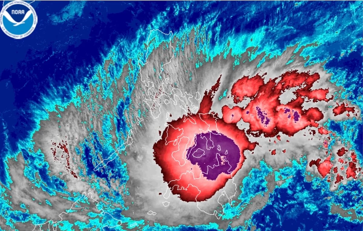
Manila: Several regions in the country are expected to be impacted as tropical storm Basyang (Penha) has already made landfall early on Friday (Feb. 6, 2026).
Based on the latest forecast, Basyang will continue traversing Agusan del Norte before emerging over the Bohol Sea, based on Tropical Cyclone Bulletin #15 issued by weather bureau Pagasa as of 5am on Friday.
Location: The centre is estimated in the vicinity of Jabonga, Agusan del Norte (9.4°N, 125.5°E).
Movement: West-northwestward at 25 km/h.
Intensity: Maximum sustained winds of 65 km/h near the center, with gusts up to 90 km/h.
Track, intensity
Based on the forecast, Basyang's centre may pass close to or make another landfall over Bohol and the southern portions of Cebu and Negros Oriental between Friday morning and afternoon.
Afterward, the storm will move over the Sulu Sea, pass near the Cuyo Islands, and cross the northern portion of Palawan.
The storm is likely to remain a tropical storm while moving through Central and Western Visayas.
It is forecast to downgrade to a tropical depression by Friday evening (Feb 6) or Saturday morning (Feb. 7), before turning into a low-pressure area by Sunday morning (Feb. 8).
Key forecast positions:
2:00 PM, February 6: In the vicinity of Kabankalan City, Negros Occidental.
2:00 AM, February 7: Over the coastal waters of Cuyo, Palawan.
2:00 PM, February 7: Over the coastal waters of Calamian Islands, Palawan.
2:00 AM, February 8: 150 km west-southwest of Coron, Palawan.
Local weathermen predict possible shifts in the path, so heavy rainfall and strong winds may affect areas outside the exact landfall points.
Pagasa has hoisted the following signals:
Signal #2
(Gale-force winds: 62-88 km/h expected in at least 24 hours, minor to moderate impacts):
Visayas: Southern portion of Eastern Samar (Guiuan, Salcedo, Mercedes, Giporlos, Balangiga, Lawaan, Quinapondan, General Macarthur, Hernani, Llorente, Balangkayan, City of Borongan, Maydolong), southern portion of Samar (Marabut, Basey, Santa Rita, Daram, Talalora, Zumarraga, Villareal, Pinabacdao, Calbiga), Biliran, rest of Leyte, rest of Cebu, rest of Negros Occidental, Guimaras, Iloilo, Capiz, Aklan, Antique.
Mindanao: Rest of Surigao del Sur, rest of Agusan del Sur, northern portion of Davao Oriental (Boston), northern portion of Davao de Oro (Monkayo, Montevista, Laak), northern portion of Davao del Norte (San Isidro, Talaingod, Kapalong), central portion of Bukidnon (San Fernando, Lantapan, City of Valencia, Talakag, Don Carlos, Maramag, Quezon, Kalilangan, Pangantucan, Cabanglasan, City of Malaybalay), Lanao del Norte, rest of Misamis Occidental, Lanao del Sur, eastern and central portions of Zamboanga del Norte (Mutia, Piñan, Polanco, Dipolog City, Dapitan City, Sibutad, Rizal, La Libertad, Salug, Bacungan, Sindangan, Jose Dalman, Manukan, Pres. Manuel A. Roxas, Katipunan, Sergio Osmeña Sr., Siayan, Godod), northern and central portions of Zamboanga del Sur (Bayog, Kumalarang, Pagadian City, Tigbao, Lakewood, Dumingag, Mahayag, Molave, Josefina, Tambulig, Aurora, Ramon Magsaysay, Sominot, Midsalip, Labangan, Tukuran), northeastern portion of Zamboanga Sibugay (Kabasalan, Diplahan, Buug, Siay).
Luzon: Southern portion of Occidental Mindoro (San Jose, Magsaysay, Rizal, Calintaan, Sablayan), southern portion of Oriental Mindoro (Mansalay, Bulalacao, Gloria, Pinamalayan, Bansud, Bongabong, Roxas), Romblon, northern portion of Palawan (Taytay, El Nido, Dumaran, Araceli) including Calamian, Cuyo, and Cagayancillo Islands, southern portion of Masbate (Mandaon, Milagros, Balud, Placer, Cawayan, Esperanza).
Signal #1
(Strong winds: 39-61 km/h expected in at least 36 hours, very light to light damage):
Visayas: Southern portion of Leyte (Matalom, Bato, Hilongos, Hindang), Southern Leyte, Bohol, central and southern portions of Cebu (Samboan, Malabuyoc, Oslob, Ginatilan, Alegria, Dalaguete, Boljoon, Alcoy, Santander, Argao, Badian, Moalboal, Ronda, Alcantara, Sibonga, Dumanjug, City of Carcar, Barili, Aloguinsan, San Fernando, Pinamungahan, City of Naga, Lapu-Lapu City, Cordova, Cebu City, City of Talisay, Minglanilla, Toledo City, Mandaue City, Consolacion, Liloan), Siquijor, Negros Oriental, southern portion of Negros Occidental (Candoni, City of Sipalay, Ilog, City of Kabankalan, Cauayan, Hinoba-An, City of Himamaylan, Binalbagan, Isabela, Moises Padilla, La Castellana, Valladolid, Pulupandan, La Carlota City, San Enrique, Pontevedra, Hinigaran).
Mindanao: Dinagat Islands, Surigao del Norte, northern portion of Surigao del Sur (Lanuza, San Miguel, Tago, Carmen, Cortes, City of Tandag, Madrid, Cantilan, Carrascal), Agusan del Norte, northern portion of Agusan del Sur (City of Bayugan, Sibagat, Esperanza), Camiguin, Misamis Oriental, northern portion of Bukidnon (Impasug-Ong, Manolo Fortich, Malitbog, Sumilao, Libona, Baungon), eastern portion of Misamis Occidental (Baliangao, Plaridel, Lopez Jaena, Oroquieta City, Calamba, Aloran, Panaon).
Hazards and precautions
Heavy Rainfall: Refer to PAGASA Weather Advisory No. 28 for detailed rainfall forecasts. Expect potential flooding and landslides in affected areas.
Severe Winds: Gale-force winds possible in coastal and upland areas. The Northeast Monsoon may enhance gusts in additional regions like Batanes, Metro Manila, and parts of Visayas and Mindanao today through Sunday.
Storm Surge: Minimal to moderate risk (up to 2.0 m) in low-lying coastal areas of Occidental Mindoro, Palawan, Visayas, and parts of Mindanao. See Storm Surge Warning No. 6.
Coastal Waters: Gale Warning in effect for eastern and central seaboards of Visayas and northern/eastern seaboards of Mindanao. Very rough seas (up to 5.0 m) in areas like Surigao del Norte and Agusan del Norte — sea travel is risky for all vessels.
Residents in affected areas are advised to prepare emergency kits, secure properties, avoid unnecessary travel, and stay updated via official Pagasa channels.
Sign up for the Daily Briefing
Get the latest news and updates straight to your inbox
Network Links
GN StoreDownload our app
© Al Nisr Publishing LLC 2026. All rights reserved.