Philippines: Tropical Cyclone Wind Signal No. 1 hoisted over southern areas of Surigao del Sur
'Basyang' to bring winds of up 70km/h, as it continues to intensify, moving southwestward
Manila: A new tropical cyclone is threatening south-eastern Philippines.
Tropical Depression "Basyang" (no international code yet) continues to move west-southwestward, the Philippine Atmospheric, Geophysical and Astronomical Services Administration (Pagasa) reported on Wednesday.
Tropical Cyclone Wind Signal No. 1 has been hoisted over the southern areas of Surigao del Sur.
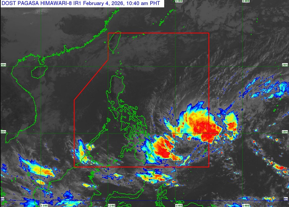
Weather satellite data as of 10.40 am (local time, GMT +8) on Wednesday, Pagasa said the centre of Basyang was estimated at around 735 km east of Hinatuan, Surigao del Sur province, in northeastern Mindanao.
The weather system is moving at 20 km/h and is packing maximum sustained winds of 55 km/h, with gusts of up to 70 km/h.
The warning signal covers the southern portion of Surigao del Sur, including the municipalities of Cagwait, Marihatag, San Agustin, Barobo, Tagbina, Hinatuan, as well as Bislig City and the towns of Lingig and Lianga.
Pagasa cautioned that areas under Signal No. 1 may experience winds ranging from 39 to 61km/h per hour, which could pose minimal to minor risks to life and property.
According to forecasters, Basyang is expected to strengthen and may develop into a tropical storm within the day as it continues to traverse the Philippine Sea.
Hazards affecting land areas
Severe Winds
The wind signals warn the public of the general wind threat over an area due to the tropical cyclone. Local winds may be slightly stronger/enhanced in coastal and upland/mountainous areas exposed to winds. Winds are less strong in areas sheltered from the prevailing wind direction.
Minimal to minor impacts from strong winds are possible within any of the areas under Wind Signal No. 1.
The highest Wind Signal that may be hoisted throughout the passage of Basyang is Wind Signal No. 2.
The surge of the Northeast Monsoon will also bring strong to gale-force gusts over the following areas (especially in coastal and upland areas exposed to winds):
Today (Wednesday, February 4, 2026): Most of Luzon, Visayas, Dinagat Islands, Caraga, Davao Region, Zamboanga Peninsula, Camiguin, Misamis Oriental, and Lanao del Norte.
Tomorrow (February 5): Most of Luzon, Visayas, Caraga, Davao Region, Northern Mindanao, Zamboanga Peninsula, Basilan, and Tawi-Tawi.
Friday (February 6): Batanes, Babuyan Islands, northern portion of mainland Cagayan, Ilocos Norte, Central Luzon, Metro Manila, CALABARZON, MIMAROPA, Bicol Region, Visayas, and most of Mindanao.
Hazards affecting coastal waters
A Gale Warning is in effect over the eastern seaboard of Visayas. Refer to Gale Warning No. 1 issued at 5:00 am today (February 4, 2026).
24-Hour Sea Condition Outlook: Up to very rough seas over the following coastal waters:
Up to 5.0 m: The seaboard of Surigao del Sur; the eastern seaboards of Siargao-Bucas Grande Islands.
Up to 4.5 m: The eastern seaboards of Northern Samar, Eastern Samar, Dinagat Islands, and northern Davao Oriental.
Sea travel is risky for all types or tonnage of vessels. All mariners must remain in port or, if underway, seek shelter or safe harbor as soon as possible until winds and waves subside.
Up to rough seas over the following coastal waters:
Up to 4.0 m: The northern and eastern seaboards of Catanduanes; the eastern seaboards of Albay and Sorsogon; the northern seaboard of Northern Samar.
Up to 3.5 m: The eastern seaboards of Isabela and northern Aurora; the northern seaboards of Camarines Norte and Camarines Sur; the northern and eastern seaboards of Polillo Islands; the remaining seaboard of Davao Oriental.
Up to 3.0 m: The seaboards of Batanes, Babuyan Islands and Ilocos Norte; the remaining seaboards of Eastern Samar and Dinagat Islands; the eastern seaboard of southern Davao del Sur.
Mariners of small seacrafts, including all types of motorbancas, are advised not to venture out to sea under these conditions, especially if inexperienced or operating ill-equipped vessels.
Up to moderate seas over the following coastal waters:
Up to 2.5 m: The seaboard of Palawan; the remaining seaboards of Aurora and Catanduanes; the seaboard of northern Quezon.
Up to 2.0 m: The seaboards of Antique and Southern Leyte; the western seaboard of Zambales, Bataan, Occidental Mindoro, Romblon, and Aklan; the eastern seaboard of southern Oriental Mindoro; the southern seaboard of Iloilo, Guimaras, and Negros Occidental; the remaining seaboards of Quezon, Bicol Region, Eastern Visayas, and Caraga,
Mariners of motorbancas and similarly sized vessels are advised to take precautionary measures while venturing out to sea and, if possible, avoid navigation under these conditions.
Other coastal waters have forecast wave heights of less than 2.0 m.
TRACK AND INTENSITY OUTLOOK
Heavy rainfall and severe winds may still be experienced in localities outside the landfall point and the forecast confidence cone. Refer to “Other Hazards affecting Land Areas” for more details.
Furthermore, the track may still shift within the limit of the forecast confidence cone.
Basyang will move generally westward for the next 36 hours before turning west northwestward beginning tomorrow (05 February) evening.
On the forecast track, the center of BASYANG will make its initial landfall over eastern Mindanao between tomorrow evening and Friday (06 February) morning.
Afterwards, it will traverse the landmass of northeastern Mindanao and Central and Western Visayas and emerge over Sulu Sea by Saturday (07 February) morning. By Saturday afternoon or evening, Basyang will cross the northern portion of Palawan, then re-emerge over the West Philippine Sea.
Basyang is forecast to gradually intensify while over the Philippine Sea and may reach tropical storm category on Wednesday.
After its initial landfall, it will weaken into tropical depression while traversing Visayas and will be downgraded to low pressure area by Sunday (08 February 2026).
Sign up for the Daily Briefing
Get the latest news and updates straight to your inbox
Network Links
GN StoreDownload our app
© Al Nisr Publishing LLC 2026. All rights reserved.