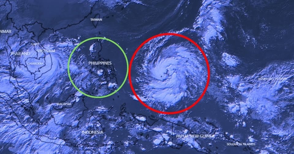
Monster storm 'Uwan': Category 4 super typhoon with 220 km/h winds set for Philippines 'direct hit'
Residents urged to stay alert to changes in forecasts while preparing for severe weather

Manila: Typhoon Uwan (International code: Fung-Wong), dubbed a "monster" storm due to its size and deadly speed, continues to move west, closer to the Philippines from the Pacific, potentially making a "direct hit" on the main island of Luzon (where Manila is).
In a bulletin issued at 5pm on Saturday (November 8), weather bureau Pagasa has reported that the storm has undergone "rapid intensification" in the last 24 hours over the Philippine Sea, east of Samar.
At 2am on Sunday (Nov. 9), the eye of the storm is seen at 290km east of the island of Catanduanes (1,512 km2), about 360km east of the capital Manila.
The powerful super-typhoon has formed in the West Pacific and is officially designated as Tropical Depression #32W.
It is forecast by the US Joint Typhoon Warning Center (JTWC) to reach devastating Category 4 strength by Sunday.
The storm is expected to bring one-minute sustained winds of up to 220 km/h (138 mph), with agencies like the Philippine weather bureau Pagasa measuring winds over a 10-minute average at around 105 knots (195 km/h).
Pagasa warns that Uwan may become a "super typhoon."
There is growing consensus among international and local weather agencies including the Japan Meteorological Agency (JMA) and JTWC that Uwan will make landfall in Northern-Central Luzon on Monday, November 10.
Warning for residents
Residents in the storm’s projected path are urged to remain vigilant and closely follow official updates, as preparations intensify for the potential catastrophic impact.
As the the JTWC predicted, Uwan has rapidly intensified over the Philippine Sea, with models showing a near certainty of this storm reaching typhoon status and super typhoon intensity over the coming weekend.
While wind speed calculations differ based on averaging periods — JTWC uses a one-minute average resulting in higher figures than the 10-minute standard used by many countries — this discrepancy highlights the storm’s overwhelming power rather than any uncertainty in its threat level.
Authorities emphasise that the situation remains fluid, and residents should stay alert to changes in forecasts while preparing urgently for severe weather conditions that could bring strong winds, torrential rains, and dangerous flooding.
What to Know:
Storm Name: Uwan (Fung Wong)
Category: Expected Category 4 Super Typhoon
Peak Winds: Up to 220 km/h (138 mph)
Expected Landfall: Monday, November 10
Target Area: Northern-Central Luzon, Philippines
Residents and local governments are gearing up for what could be one of the most destructive storms of 2025.
Sign up for the Daily Briefing
Get the latest news and updates straight to your inbox
Network Links
GN StoreDownload our app
© Al Nisr Publishing LLC 2026. All rights reserved.