Typhoon Tino (Kalmaegi) whips central Philippines with up to 155 km/h gusts, leaves extensive damage
Typhoon kills 2, leaves extensive damage, flights cancelled and warnings raised
Torrential rains and sustained winds of up to 155 km/h felled trees and electric posts, blocked road access, flooded communities, and killed at least 26 people in central Philippines.
The typhoon affected air and sea routes as well as search-and-rescue operations as Typhoon Tino (Kalmaegi) hammered central Philippines overnight on Monday (November), and into Tuesday (November 4).
As floodwaters swallowed homes in Bacayan, Cebu City at daybreak Tuesday (November 4), resperate residents called out for help.
Typhoon Tino intensified while trekking westward across the central and western Philippines, prompting widespread flight cancellations and weather alerts across the country.
Thousands of homes are without power in several islands while huge swaths of land area flooded, as reported by residents on social media.
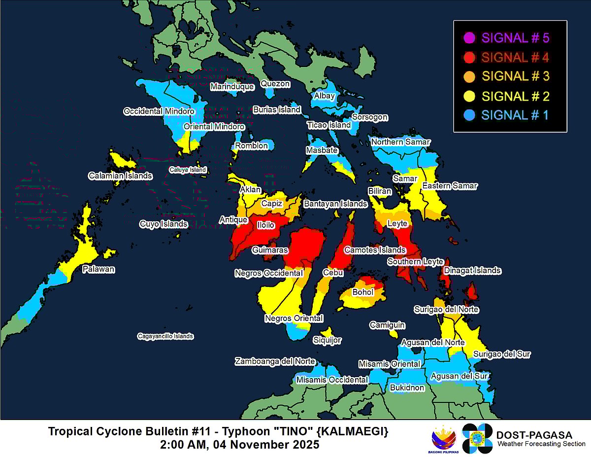
Pagasa's Tropical Cyclone Bulletin issued at 2am on November 4, 2025, confirmed Tino's landfall over Silago in Southern Leyte around midnight, shortly after reaching typhoon strength.
The storm's eye was then approximately 360 km east of Guiuan, Eastern Samar, before crossing central Visayas.
Its path evoked memories of Typhoon Haiyan (Yolanda) in 2013, which devastated the same regions.
Wind signals were hoisted progressively:
Signal #5 (destructive winds >220 km/h possible) over isolated spots in Eastern Samar and Dinagat Islands
#4 in Southern Leyte and nearby areas
#3 across parts of Visayas and Mindanao
#2 zones dominating Samar-Leyte and Caraga.
#1 in southern Luzon fringes like Palawan and Occidental Mindoro.
A Pagasa "heat map" highlighted widespread alerts.
Impacts were severe: Torrential rains of 50-200 mm triggered flash floods and landslides, enhanced by the shear line.
Evacuations
Over 150,000 people evacuated from Eastern Samar, Leyte, and Southern Leyte; schools and flights canceled.
Coastal warnings urged evacuations amid storm surges up to 3 meters. Post-landfall, Tino traversed Visayas, northern Palawan, and Sulu Sea, re-emerging over the West Philippine Sea by November 5, heading toward Vietnam as a weakening typhoon by November 6.
As of early November 4, vigilance remained high, with PAGASA monitoring lahars near Kanlaon Volcano and ongoing heavy rains. Tino underscored the archipelago's vulnerability, with rapid intensification over warm seas amplifying risks in an era of climate extremes.
Current status and path
As of the 8pm advisory, the weather bureau Pagasa forecasts that Typhoon Tino will be in the vicinity of Asturias, Cebu by 5am on November 4, packing maximum sustained winds (MSW) of 140 km/h.
The Transcentral Highway of Barangay Sirao, Cebu city became impassable on Monday night after strong winds felled trees and power distribution posts due to Typhoon Tino.
The typhoon will then move steadily westward, affecting major sea and air routes, especially around the Visayas and Palawan area.
Within 24 hours (by 5pm, November 4), Tino is projected to be over the coastal waters of the Cuyo Islands, still maintaining winds of 140 km/h. Over the next two days, the typhoon is expected to approach and move off the coast of Palawan, further strengthening, with projections of 150-155 km/h by November 6 before exiting the Philippine Area of Responsibility (PAR).
Projected intensity and movement
By November 5, Tino is expected to be 185 km southwest of Coron, Palawan and then move further westward.
The typhoon will intensify further as it heads over open sea, reaching up to 155 km/h at its peak intensity west of Palawan.
As it leaves the PAR by November 6-7, it is forecast to gradually weaken, downgrading to a tropical storm near the border with Thailand’s Ubon Ratchathani region.
Impact and safety measures
The advance of Typhoon Tino has caused significant disruption to travel and daily life, especially in the Visayas and MIMAROPA regions:
At least 75 domestic flights (Philippine Airlines, AirAsia, Cebu Pacific) were affected/cancelled, stranding thousands of passengers.
Local disaster agencies urge residents in affected regions to prepare for possible floods, landslides, and strong winds, especially in central Visayas and northern Palawan.
PAGASA and the Civil Aviation Authority of the Philippines (CAAP) continue to issue regular updates, advising travellers and residents to stay alert for further disruptions.
Outlook
Typhoon Tino is expected to cross the West Philippine Sea after impacting Palawan, further affecting international shipping routes and possibly bringing rain to parts of mainland Southeast Asia as a weakening tropical storm.
As of the latest forecast, the worst of the winds and rain is expected over the next 36 hours for the central and western Philippines.
Officials remind all residents and travelers to monitor Pagasa bulletins and adhere to local government advisories as Typhoon Tino makes its closest approach over land before exiting the country’s area of responsibility by late November 7.
Sign up for the Daily Briefing
Get the latest news and updates straight to your inbox
Network Links
GN StoreDownload our app
© Al Nisr Publishing LLC 2026. All rights reserved.