Tropical storm Ada (Nokaen): Schools shut in affected areas, latest updates
Ada is the first weather system to enter the Philippine Area of Responsibility in 2026
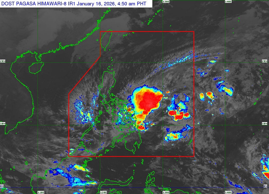
Tropical Storm Ada (international code: Nokaen) continues to move slowly north-northwestward over the Philippine Sea east of Eastern Visayas, weather trackers said on Friday.
Authorities warned that Ada, the first tropical cyclone of this year, could trigger lahars and muddy streamflows around Mayon Volcano on Luzon island, authorities said Friday.
Pagasa, the state weather bureau, said Ada packs maximum sustained winds of 65 km/h near the centre, with gusts of up to 80 km/h.
Schools shut in affected regions
Class suspensions or shifts to alternative modes have been declared, and currently apply in Bicol Region (e.g., Albay, Sorsogon, parts of Camarines Sur) and Eastern Visayas (e.g., Eastern Samar, Samar towns like Catbalogan City, Biliran).
Cebu has reported localised school cancellations as well.
Ada is the first weather system to enter the Philippine Area of Responsibility in 2026.
Weather agency Pagasa issued Tropical Cyclone Bulletin No. 8 at 5am on Friday, January 16, 2026 (valid until 11am).
Current status and position:
Location: The centre is estimated at 370 km east of Surigao City, Surigao del Norte, or 430 km east of Maasin City, Southern Leyte (coordinates: 10.4°N, 128.8°E).
Intensity: Maximum sustained winds of 65 km/h near the center, with gusts up to 80 km/h. Ada is expected to remain a tropical storm while traversing the sea east of Visayas and Southern Luzon but may weaken into a tropical depression by Tuesday, January 20.
Movement: Currently moving north-northwestward at a slow pace. It is forecast to shift generally northwestward through Friday (January 16) and Saturday (January 17), then slowly north-northwestward to northeastward by Sunday (January 18), before "curling" southeastward by Tuesday evening (January 20) over the sea east of the Bicol Region.
Forecast track and positions
Based on the track and intensity forecast:
2:00 PM, January 16: 225 km east of Guiuan, Eastern Samar.
2:00 AM, January 17: 130 km east-northeast of Borongan City, Eastern Samar.
2:00 PM, January 17: 165 km east of Juban, Sorsogon.
2:00 AM, January 18: 95 km east of Virac, Catanduanes.
2:00 PM, January 18: 240 km east of Daet, Camarines Norte.
2:00 AM, January 19: 420 km east of Infanta, Quezon.
2:00 AM, January 20: 530 km east of Infanta, Quezon.
'Will remain offshore'
Ada is not expected to make landfall over the Philippines but will remain offshore, potentially bringing indirect impacts.
Warnings and signals
Tropical Cyclone Wind Signals (TCWS): TCWS No. 1 is in effect over:
Luzon: Eastern portion of Camarines Norte, Camarines Sur, Catanduanes, Albay, Sorsogon, and the eastern portion of mainland Masbate (including Ticao and Burias Islands).
Visayas: Northern Samar, Samar, Eastern Samar, Biliran, northern and central portions of Leyte, and the eastern portion of Southern Leyte.
Mindanao: Dinagat Islands, Surigao del Norte, and Surigao del Sur.
The highest wind signal that may be raised is No. 2, depending on intensification and proximity.
Hazards
Strong to gale-force gusts from the Northeast Monsoon enhanced by Ada are expected in areas like Batanes, Babuyan Islands, Ilocos Norte, eastern Isabela, Aurora, CALABARZON, Occidental Mindoro, Oriental Mindoro, Romblon, Marinduque, Cuyo Islands, Bicol Region, Visayas, and Caraga through the coming days.
Minimal to moderate risk of storm surge (up to 2.0 meters) in low-lying coastal areas of Catanduanes, Albay, Sorsogon, Northern Samar, Eastern Samar, Samar, Biliran, and Leyte.
Emergency workers urged residents in affected areas to monitor for heavy rainfall, strong winds, and potential flooding or landslides.
The next bulletin is expected at 11am January 16, 2026. For real-time updates, refer to PAGASA's official channels.
Sign up for the Daily Briefing
Get the latest news and updates straight to your inbox
Network Links
GN StoreDownload our app
© Al Nisr Publishing LLC 2026. All rights reserved.