The storm will track through southern Luzon and pass south of Metro Manila, bringing heavy rains exceeding 200 mm in some areas and raising risks of flooding, landslides, and storm surges, particularly amid ongoing recovery from Super Typhoon "Nando" (international code: Ragasa).
Philippines cyclone: 'Direct hit' of populated areas seen as tropical storm Opong threat grows
Signal No. 1 hoisted as storm gains momentum, schools, government work suspended
Last updated:
2 MIN READ
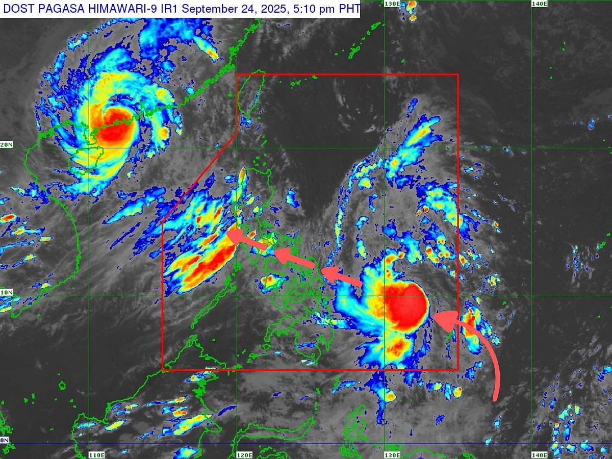
Location of Opong (international code: Bualoi) issued by Philippine weather bureau Pagasa at 5pm, 24 September 2025. The forecast is valid for broadcast until the next bulletin at 11pm Manila time (on Wednesday).
Pagasa
Manila: Amid the cyclone season in the western Pacific, severe tropical storm Opong (international name: Bualoi) has intensified rapidly over the Philippine Sea, posing significant risks to eastern and southern regions of the country.
As of September 24, 2025, Opong has upgraded from a tropical depression to a tropical storm, with maximum sustained winds of 65 km/h near the center and gusts up to 80 km/h, according to the Philippine Atmospheric, Geophysical and Astronomical Services Administration (Pagasa).
Opong is the 15th storm during the tropical cyclones season, typically May–November in the Pacific.
Located approximately 670 km east of Surigao City, Surigao del Norte, the storm is moving west-northwestward at 20 km/h, with gale-force winds extending up to 400 km from its core.
PAGASA forecasts Opong to continue strengthening, potentially reaching typhoon category before making landfall over the Bicol Region on Friday afternoon, September 26.
Heavy rain
It is expected to traverse Southern Luzon through Saturday, weakening slightly but maintaining severe tropical storm strength during its passage across the archipelago.
Re-intensification is likely once it emerges over the West Philippine Sea.
Heavy rainfall from Opong, enhanced by the southwest monsoon (locally known as habagat), will begin affecting areas as early as Thursday, September 25, with risks of flooding and landslides in low-lying regions like Zambales, Bataan, and Occidental Mindoro.
Government work suspended
In response, President Ferdinand Marcos Jr. has suspended government work and classes at all levels in Sorsogon, Masbate, Northern Samar, and Eastern Samar for Thursday, while local executives in Quezon, Marinduque, Camarines Norte, Camarines Sur, Catanduanes, Albay, Samar, and Biliran have followed suit.
He has also issued a memorandum calling for community vigilance and directing all agencies involved in disaster response, search and rescue operations.
Wind Signal No. 1 is hoisted over northeastern Mindanao, Eastern Visayas, and parts of Bicol, with Signal No. 2 raised in select Visayas provinces; the highest expected is Signal No. 3.
A storm surge warning may be issued today or tomorrow, highlighting coastal flooding threats in Southern Luzon and Eastern Visayas.
On X, discussions are heating up with weathermen and emergency workers urging safety amid the storm's approach.
Updates
PAGASA's Tropical Cyclone Warning Advisory No. 3, and valid until 11pm on Wednesday, highlighted Signal No. 1 in Samar provinces.
Opong serves as a stark reminder of the Philippines' vulnerability to typhoons, especially post-Nando.
Residents are advised to monitor updates, secure properties, and heed evacuation orders. With climate change amplifying storm intensity, proactive measures are crucial for minimizing loss.
As Opong barrels closer, solidarity and preparedness will be key to weathering this tempest.
Sign up for the Daily Briefing
Get the latest news and updates straight to your inbox
Network Links
GN StoreAbout Gulf NewsTerms & ConditionsReach by GNSitemapContact usPrivacy PolicyGN FocusHave your sayWork with usAdvertise with usGulf News epaperPrinting Services
Download our app
© Al Nisr Publishing LLC 2026. All rights reserved.