Philippines: 2 cyclones stir up Luzon weather, flood hits northern Thailand
Tropical Storm ‘Emong’ intensifies as it moves southwestward over West Philippine Sea

Manila: Two cyclones are now within the Philippine Area of Responsibility (PAR) as a low-pressure area near Northern Luzon developed into Tropical Depression Emong on Wednesday, July 23.
It follows Dante (international name: Francisco), which formed earlier off Aurora on Tuesday, July 22.
Dante intensified into a tropical storm by 8 am on Wednesday and was located approximately 900 km east of Extreme Northern Luzon at 10 am.
Dante is currently sustaining winds of 65 kph hour with gusts up to 80 kph.
At the same time, Emong was spotted about 115 kilometers west-northwest of Laoag City, Ilocos Norte.
Weather bureau Pagasa is advising residents in affected areas to stay alert for possible weather disturbances.
As of 11 am Wednesday, Emong was moving west-southwest at 35 kph, with maximum sustained winds of 45 kph and gusts up to 55 kph.
Pagasa has raised Tropical Cyclone Wind Signal No. 1 over these areas due to Emong’s strong winds:
Western Ilocos Sur, including Vigan, Candon, Tagudin, and nearby towns
Northwestern La Union, including San Fernando, Bacnotan, and Luna
Western Pangasinan, including Alaminos City, Bolinao, and Anda.
The impacts are expected to be minimal to minor, but Emong could intensify into a tropical storm by Thursday afternoon or evening.
If so, Signal No. 2 may be raised.
Weather specialist Benison Estareja noted that Emong may make landfall over the Ilocos Region if it shifts slightly east.
It's currently expected to move southwestward before looping over the West Philippine Sea, possibly due to interaction with Dante.
Dante gains strength
While Dante strengthened into a tropical storm on Wednesday morning, it is not expected to make landfall in the Philippines, but its circulation will enhance the southwest monsoon (Habagat) — bringing rains across much of Luzon and parts of the Visayas through Friday.
Pagasa is also monitoring another low-pressure area outside PAR, about 2,340 km east of Eastern Visayas, which has a moderate chance of developing into a tropical depression within 24 hours.
Emong intensifies
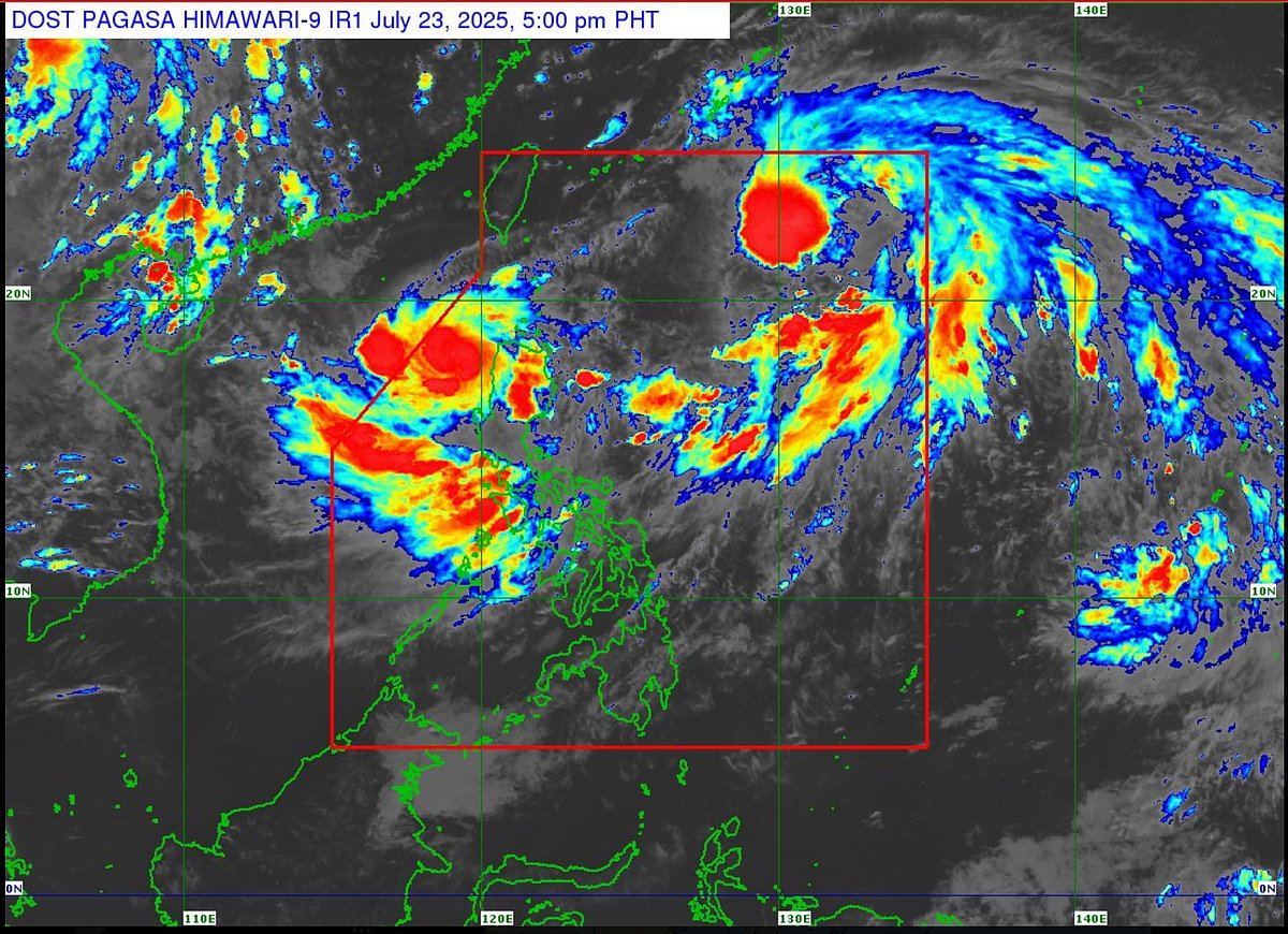
Tropical Storm Emong has officially intensified and is currently tracking southwestward over the West Philippine Sea, according to the latest Pagasa bulletin, issued this Wednesday, July 23, 2025, at 5pm.
Satellite imagery from the Himawari-9 IR1 sensor captures the sprawling cloud masses and intense convective activity surrounding Emong.
Bright red and orange clusters indicate powerful thunderstorms and heavy rainfall embedded within the storm system.
The infrared satellite map reveals Emong positioned northwest of the Philippines, drawing closer to the country's northern and western maritime zones.
Pagasa’s bulletin highlights that Emong’s sustained wind speeds and organised cloud structure justify its upgrade from a tropical depression to a tropical storm.
This intensification means stronger winds and heavier rain can be expected, particularly in the coastal and island communities in the storm’s projected path.
Flood hits northern Thailand
As of July 23, 2025, northern Thailand continues to experience significant flooding caused by persistent heavy rains linked to Tropical Storm Wipha and the prevailing southwest monsoon.
Severe flooding has been reported in provinces including Nan, Chiang Mai, and Udon Thani. In Nan province, flash floods triggered by continuous rainfall from July 16 to 17 have affected around 130 households (about 481 people), with localizsed flooding still ongoing in several districts.
Tropical Storm Wipha, which has made landfall in Vietnam, continues to influence weather conditions over Thailand.
The Thai Meteorological Department warns of widespread heavy to very heavy rainfall accompanied by strong winds across the northern, northeastern, central, and eastern regions. Coastal areas are susceptible to dangerous sea conditions, with waves reaching 2 to 4 meters in the Andaman Sea and Gulf of Thailand.
Vigilance urged
Residents of northern and western coastal provinces are urged to remain vigilant and monitor official weather advisories.
The combination of these elements raises the risk of flash floods, landslides, and maritime hazards.
Fishermen and those involved in sea travel are advised to avoid venturing out into the West Philippine Sea until conditions improve.
Local authorities are preparing necessary contingency plans and encouraging communities to be ready for possible evacuation or protective measures, especially in low-lying areas prone to flooding.
The next bulletin on Emong’s trajectory and strength is expected by 11:00 PM today.
Stay tuned to Pagasa’s official channels for the latest updates, and heed instructions from local disaster risk reduction and management offices as the situation unfolds.
Sign up for the Daily Briefing
Get the latest news and updates straight to your inbox
Network Links
GN StoreDownload our app
© Al Nisr Publishing LLC 2026. All rights reserved.