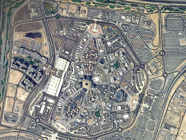
Look: Image of Expo 2020 Dubai site taken from space
UAE-made satellite KhalifaSat shares photo taken from 613km above earth
Also In This Package
What pulls sports events and stars to Dubai
From the Editors: No room for risk in UAE schools
Look: Sheikh Mohammed reviews Expo 2020 preparations
Photos: Taliban seizes control of Kabul airport
Tears of joy and pain at the Tokyo 2020 Paralympics
Photos: Taliban seizes control of Kabul airport
Tears of joy and pain at the Tokyo 2020 Paralympics
Dubai: With one month to go before the opening of Dubai Expo 2020, a stunning photo taken from space by KhalifaSat was shared by the Mohammed Bin Rashid Space Centre on Wednesday.
The photo taken from around 613km above Earth prominently shows Al Wasl Plaza and the entire site of the global cultural event that will bring together 191 countries in the UAE for the world’s greatest show that will open on October 1.
Also Read
Look: Images of the UAE from space over the yearsSee: Image taken by UAE’s KhalifaSat shows impact of California wildfireLook: UAE’s KhalifaSat captures Sharjah’s largest mosque from spaceMBRSC tweeted: “One month to go for the opening of Expo 2020 Dubai. This photo, taken by #KhalifaSat from space, shows the site of the global cultural event that will bring together 191 countries in the UAE.”
Emirati-made satellite
KhalifaSat is the first entirely Emirati-made earth observation satellite that was launched into orbit from Japan’s Tanegashima Space Centre on October 30, 2018. It provides high-resolution images from a nominal altitude of 613km above Earth which are used for various objectives, including urban planning, monitoring of environmental changes and aiding rescuers in natural disasters.
Sign up for the Daily Briefing
Get the latest news and updates straight to your inbox
Network Links
GN StoreDownload our app
© Al Nisr Publishing LLC 2026. All rights reserved.