Philippines: Monster December storm Rai now packs gusts of up to 170 km/h
December danger: Storm Signal No. 3 up in 4 areas, No. 2 up in several areas
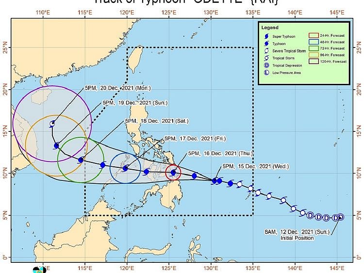
MANILA: Tropical storm Rai further intensified on Wednesday evening as it barrelled towards eastern Philippines packing gusts of up to 170 km/h, weathermen said.
The severe tropical storm developing over the vast expanse of the Pacific Ocean is set to crash into eastern Philippines Caraga-Eastern Visayas on Thursday.
In an 11pm update on Wednesday, Philippine weathermen raised Storm Signal No. 3 in four areas on the islands of Mindanao as Typhoon Rai (locally known as "Odette") gained intensity on Thursday night.
Images from Himawari-8 weather satellite tracked the eye of the typhoon at 470 km east of Surigao City, Surigao Del Norte, according to the Philippine Atmospheric Geophysical and Astronomical Services Administration’s (Pagasa).
The storm was barrelling with sustained winds of up 140 kph, with gusts reaching up to 170 kph, move westward at 15 km/h.
Signal No. 3 has been raised in the following four areas in Mindanao, where the typhoon is expected to carry destructive winds within the next 18 hours:
Signal No. 3 has been raised in 19 areas, where damaging gale-to-storm-force winds are then expected within 24 hours:
Weathermen are closely tracking the storm as it hits land. December typhoons are common in Philippines — 2019, 2016, 2015, 2014, 2013 and 2012 all seeing impacts.
Sign up for the Daily Briefing
Get the latest news and updates straight to your inbox
Network Links
GN StoreDownload our app
© Al Nisr Publishing LLC 2026. All rights reserved.