Monster typhoon Inday (Bavi) enters Philippines: Signal No. 1 raised over 7 areas in Luzon
Entry sparks wind signals, flight and sea suspensions across northern Philippines
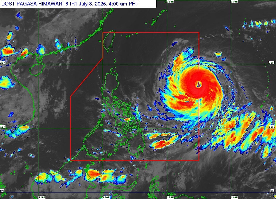
Manila: Super Typhoon Inday (international name Bavi) has fully entered the Philippine Area of Responsibility (PAR), according to the state weather bureau, as forecasters continue to monitor the powerful cyclone's movement over the Philippine Sea.
In its 5 am tropical cyclone bulletin on Wednesday, the Philippine Atmospheric, Geophysical and Astronomical Services Administration (Pagasa) said the center of Inday entered the PAR at around 3 am.
The storm was estimated at about 1,405 km east of Northern Luzon, moving generally westward at 20 to 25 km (12 to 16 miles) per hour.
Get updated faster and for FREE: Download the Gulf News app now - simply click here
The super typhoon was packing maximum sustained winds of 185 kph (115 mph) near the centre and gusts of up to 230 kph (143 mph).
Pagasa said Inday remains over open waters well east of Luzon, with no tropical cyclone wind signals raised as of the latest advisory.
However, the agency urged the public and local disaster officials to continue monitoring forecasts as the cyclone remains a powerful weather system capable of changing track and intensity over the coming days.
Tropical Cyclone Wind Signal (TCWS) No. 1 is now in effect over:
Batanes
Cagayan (including Babuyan Islands)
Northern and central Isabela
Apayao
Eastern Kalinga
Northern Aurora
Northern and central Catanduanes
Strong winds are expected to affect these areas within the next 36 hours. Pagasa notes that Inday is forecast to maintain much of its strength before beginning to weaken later on July 9.
It is unlikely to make direct landfall in the Philippines but will continue enhancing the southwest monsoon (habagat), bringing gusty conditions, heavy rains, and rough seas to broader parts of Luzon and potentially Visayas.
Key updates & impacts
Sea travel suspensions
All sea voyages suspended in northern and central Catanduanes; vessels only allowed to designated safe shelters. Philippine Coast Guard urges strict compliance for safety.
Local government alerts
DILG has raised Alert Levels in affected provinces for preparedness.
PAGASA will continue issuing bulletins every six hours, with hourly updates as needed. The highest signals expected remain in the No. 2–3 range for some northern/eastern areas.
Public advisory
Residents in signal areas are strongly urged to secure loose objects, prepare emergency kits, and monitor official Pagasa channels.
Fisherfolk and those in coastal or low-lying zones are also advised to take extra precautions due to monsoon-enhanced rains and waves.
Sign up for the Daily Briefing
Get the latest news and updates straight to your inbox
Network Links
GN StoreDownload our app
© Al Nisr Publishing LLC 2026. All rights reserved.