Magnitude 7.4 earthquake strikes off Indonesia, tsunami alert lifted
Tsunami threat to coastlines in parts of Indonesia, Philippines and Malaysia seen: USGS
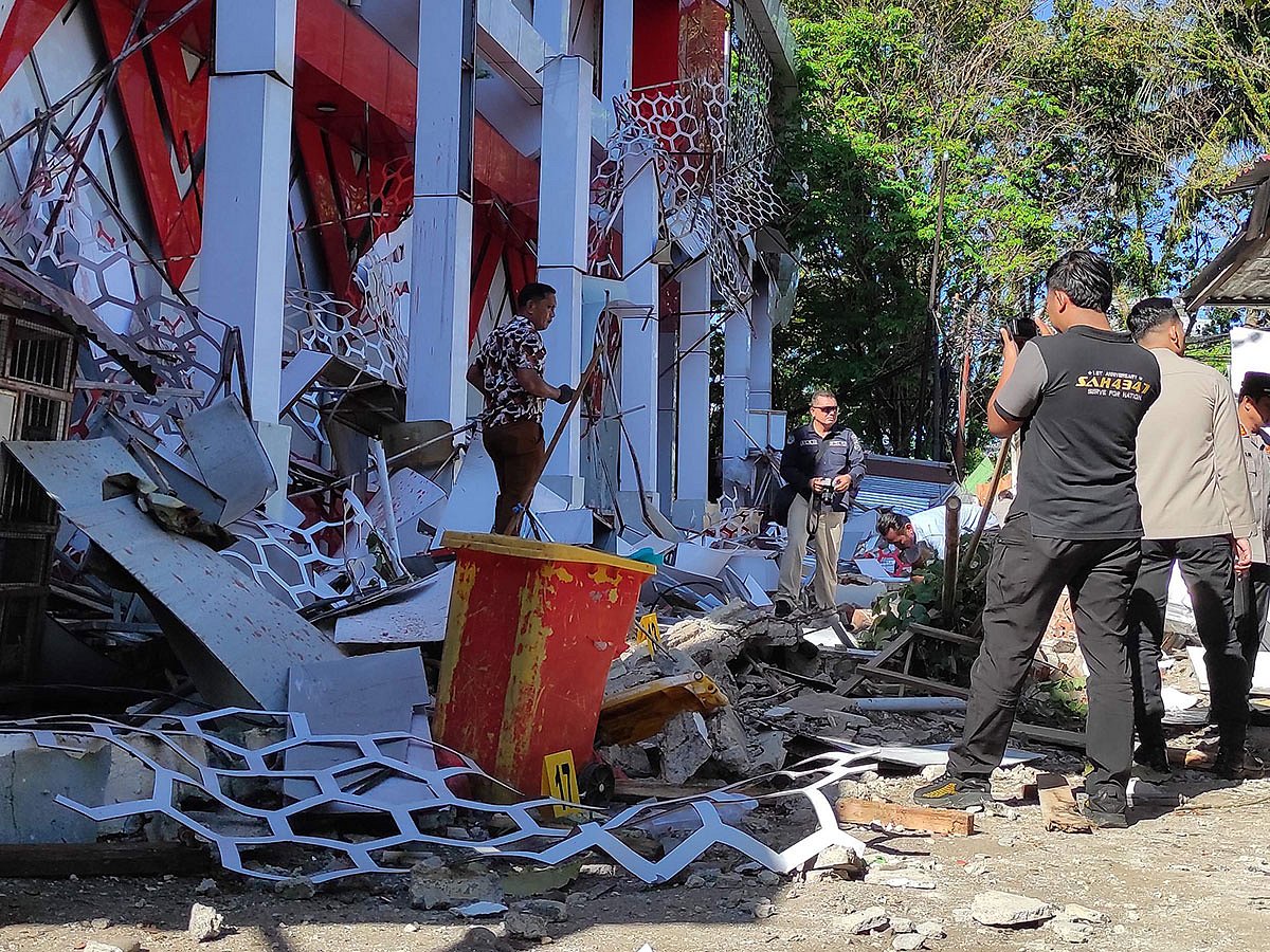
A major 7.4-magnitude quake struck off the coast of eastern Indonesia on Thursday, killing one person, damaging buildings and sending people running into the streets in panic.
The early-morning tremor in the Molucca Sea between the Sulawesi and Maluku island groups triggered waves up to 75 centimetres (2.5 feet) high in places and prompted a tsunami warning that was subsequently lifted.
Get updated faster and for FREE: Download the Gulf News app now - simply click here.
"I didn't know what to do. I was just trying to save my family," street food vendor Siti Rohayati, 58, told AFP of the moment the quake hit during the breakfast rush in Manado in North Sulawesi province.
"All that mattered was getting my children away safely. I pushed all three of them and told them: 'Run!'"
One person was killed when a building collapsed in Manado, and another was injured, search and rescue official George Leo Mercy Randang told AFP.
The victim was "buried under the rubble", he said, adding that authorities were following up on reports of more people injured.
The US Geological Survey (USGS) said the tremor hit at a shallow depth of 35 kilometres.
The Hawaii-based Pacific Tsunami Warning Center (PTWC) initially said hazardous tsunami waves were possible within 1,000 kilometres (621 miles) of the epicentre along the coasts of Indonesia, the Philippines and Malaysia.
Elevated waves were observed in nine locations in North Maluku, North Sulawesi and Gorontalo provinces, with the highest hitting 75 centimetres in North Minahasa, according to Indonesia's BMKG geological agency.
The PTWC lifted its warning just over two hours after the tremor, saying the tsunami threat "has now passed".
Budi Nurgianto, a 42-year-old resident of Ternate in North Maluku province, said he was inside his house when the tremor struck, sending people outside in terror.
"The quake was felt strongly. I heard it first from the walls of the house that shook," he said.
"When I went outside, there were many people outside. They were panicked. The quake was felt (for) quite long, more than a minute.
"I even saw some people leaving their house without having finished their shower."
Aftershocks
Dozens of aftershocks rippled through the area after the main quake, Teuku Faisal Fathani, the head of the geological agency, told journalists in the capital Jakarta.
One of them had a magnitude of 5.9, USGS data showed.
An AFP journalist in Manado, about 300 kilometres west of Ternate by sea, said the shaking woke him and others in the city of some 450,000 people.
"I immediately woke up and left my house. People (were) immediately scrambling outside. There is a school and the pupils rushed outside," he said.
The shaking persisted for "quite long" but he did not witness "significant damage", he added.
The PTWC had initially warned that tsunami waves of up to one metre were possible for parts of Indonesia, and smaller ones were possible for the Philippines, Malaysia, Japan, Taiwan, Guam and Palau.
The Japan Meteorological Agency said it expected "slight changes" in the sea level along the Pacific coast from northern Hokkaido to southern Okinawa, but has not issued any warnings.
The earthquake centres of the Philippines and Malaysia have also not issued tsunami alerts.
Indonesia and neighbouring countries experience frequent earthquakes due to their location in the Pacific "Ring of Fire" - an arc of intense seismic activity where tectonic plates collide that stretches from Japan through Southeast Asia and across the Pacific basin.
In 2004, a magnitude-9.1 quake struck the westernmost Aceh province, causing a tsunami and killing more than 170,000 people in Indonesia.
Network Links
GN StoreDownload our app
© Al Nisr Publishing LLC 2026. All rights reserved.