Polar vortex 'weakening': What really happens — why winter cold snaps could become more 'erratic'
Arctic air disruptions linked to polar vortex changes could alter global weather
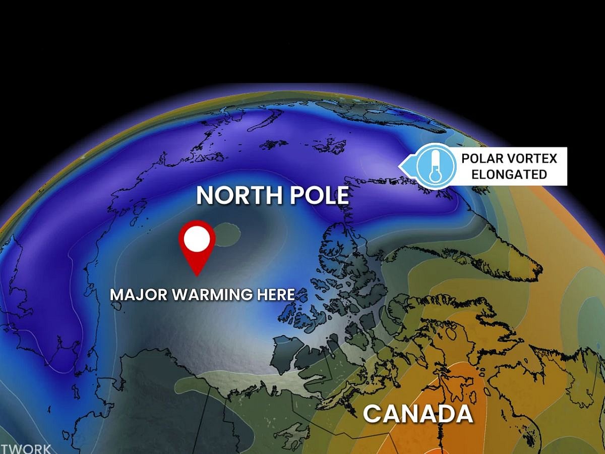
Powerful winds normally circle high above the Arctic North Pole each winter, helping contain some of Earth’s coldest air.
But this circulation, known as the "polar vortex", has "weakened" and shifted in recent days, say climate scientists.
Now, Western news media are reporting, citing weathermen and scientists who say an event this early in November is "unprecedented" in modern observations.
Such disruptions can occur in winter.
Similar disruptions have sometimes been followed by colder weather in parts of Europe and North America. But with few early-season examples for comparison, forecasters face greater uncertainty about the winter outlook.
In general, the polar vortex is a vast, spinning pool of cold air high above the Arctic, held in place by westerly winds in the stratosphere.
The polar vortex is not a single storm. There are two related features often called the “polar vortex”: a tropospheric vortex near the surface and a stronger stratospheric vortex high above it.
The stratospheric version forms in winter because of the sharp temperature difference between the dark Arctic and warmer lower latitudes.
A strong vortex tends to keep cold air locked around the pole. When those winds "weaken" or "reverse", the vortex can become "distorted", allowing Arctic air to spill toward mid-latitudes.
It means the fast-moving belt of high-altitude winds spinning around the Arctic has lost its tight, organised shape.
Loss of containment: Normally, a strong polar vortex acts like a "fence", trapping the coldest Arctic air tightly around the North Pole.
'Distortion' and waving: When those westerly winds slow down, stall, or flip direction (often triggered by a sudden stratospheric warning event event), the vortex wobbles, stretches, or splits into multiple pieces.
Jet stream buckling: This disruption forces the polar jet stream (the river of air lower down that guides daily weather) to become deeply "wavy" and buckled rather than flowing straight from west to east.
Spilling Arctic air: The large, loopy waves in the jet stream create open pathways — or "slides" — that allow frigid, sub-zero Arctic air to plunge southward into mid-latitude regions like North America, Europe, or parts of Asia, while warm air gets pushed up toward the pole.
A weak or stretched vortex can make the jet stream wavier, creating blocking patterns that can park cold air over North America, Europe or Asia for days or weeks.
A sudden stratospheric warming is the most dramatic disruption.
Temperatures in the upper polar stratosphere can rise sharply, weakening or reversing the vortex’s winds. The disturbance can then propagate downward, altering the jet stream and surface weather in the weeks that follow.
This does not mean the polar vortex “hits” a country. It means the atmosphere’s large-scale circulation changes, sometimes favouring cold outbreaks, storms or persistent ridges of high pressure.
The UK Met Office has reported the polar vortex high above the North Pole is being "disturbed", with signs that a sudden stratospheric warming (SSW) may develop. Some model runs suggest winds around the vortex could briefly reverse, but the Met Office says the expected change is weak, short-lived and "uncertain". Now, frost is expected to become more "widespread", with icy surfaces possible where showers occur. Snow is forecast mainly over higher ground in Scotland and northern and eastern coastal areas. The Met Office says a major SSW would not automatically bring snow or severe cold to the UK.
A 2026 study in Nature Communications found that changes in the stratospheric polar vortex can influence Arctic high clouds.
This create a "radiative pathway" that affects Arctic Ocean warming and sea-ice loss over the Barents-Kara Sea.
It estimated that strong-vortex events could contribute up to 1.7 Kelvin of delayed Arctic Ocean warming relative to climatology.
Another 2026 study found that reduced Arctic sea ice can increase the frequency of successive sudden stratospheric warming events, suggesting a possible feedback between sea-ice loss and stratospheric disruption.
Research published in 2025 found that human-induced warming is reducing the intensity of extreme cold surges overall, even though localised cold outbreaks can still occur.
A disrupted polar vortex can raise the odds of unusually cold, snowy or stormy weather in parts of the Northern Hemisphere.
But it is not a guarantee: its effects depend on the jet stream, ocean temperatures, blocking patterns and regional geography.
For countries near the equator and the tropics, the direct impact is limited.
Countries in these regions are the least affected, but a weakened polar vortex can influence global circulation patterns, including the behaviour of the East Asian winter monsoon and cold-air surges toward East Asia.
CLIMATE ENSEMBLE: A climate model is a computer simulation of the atmosphere, oceans, ice and land. Instead of running it once, scientists "run" it many times with slightly different starting conditions. Each run produces a slightly different weather outcome. By comparing hundreds or thousands of runs, researchers can see which patterns appear repeatedly and which are likely just chance. Think of it as rolling dice many times. One roll cannot prove a pattern. Hundreds of rolls can reveal whether the dice are genuinely "loaded". (Source: NOAA)
Scientists are using large climate-model ensembles to separate the vortex’s influence from natural weather variability.
The key question is whether Arctic warming and sea-ice loss will make vortex disruptions more frequent, more persistent or more consequential for mid-latitude winters.
This means: scientists are trying to answer a difficult question: is the polar vortex becoming more unstable because of climate change, or are the disruptions simply part of normal weather ups and downs?
They use many repeated climate-model simulations — called "ensembles" — to separate a real, human-influenced signal from random atmospheric “noise.”
“Natural weather variability” means ordinary, short-term atmospheric variation: a strong jet stream one winter, a blocking high-pressure system the next, or a sudden stratospheric warming that happens without a clear long-term cause.
The signal is the part consistently linked to a "driver" — such as Arctic warming, sea-ice loss, greenhouse-gas emissions or a particular phase of El Niño.
The noise is the part caused by the atmosphere’s own internal variability.
Scientists compare model runs with and without sea-ice loss, or with different levels of Arctic warming.
If the polar vortex "weakens" in many runs under sea-ice loss, that suggests a real connection rather than coincidence.
Polar vortex: Naturally variable
The polar vortex is naturally variable. A single cold winter in Europe, North America or Asia cannot prove that Arctic warming caused it.
Even large "ensembles" can retain substantial internal variability. A review cited by NOAA notes that 100-member ensembles may still contain enough natural variability to obscure the response to sea-ice loss.
The effect may also depend on other climate conditions. A 2025 study found that sea-ice loss in the Barents-Kara Sea weakened the stratospheric polar vortex, but the size of that effect changed with El Niño, La Niña and the Quasi-Biennial Oscillation.
Sign up for the Daily Briefing
Get the latest news and updates straight to your inbox
Network Links
GN StoreDownload our app
© Al Nisr Publishing LLC 2026. All rights reserved.