Tropical cyclone alert: Jacinto forms over West Philippine Sea, rains hit Luzon
Residents in affected areas are urged to remain alert for flash floods and landslides
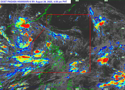
Dubai: A low pressure area over the West Philippine Sea strengthened into Tropical Depression Jacinto on Thursday, according to state weather bureau PAGASA.
As of 4.50pm (local time), the storm was located about 470 kilometers west of Iba, Zambales. It was moving north-northwest at 10 kilometers per hour, carrying maximum sustained winds of 45 kph and gusts of up to 55 kph. Central pressure was estimated at 1002 hPa.
Jacinto is expected to exit the Philippine Area of Responsibility (PAR) by Thursday night and will not make landfall. Because of this, PAGASA said no tropical cyclone wind signals will be raised.
Still, the storm’s trough, or outer extension, will continue to bring scattered rains over the Ilocos Region, the Cordillera Administrative Region, and parts of Central Luzon, including Zambales, Bataan, Tarlac, Pampanga, Isabela, Quirino, and Nueva Vizcaya.
The southwest monsoon, slightly boosted by Jacinto, will also dump moderate to heavy rains over Palawan and the western portions of Mindoro, Panay, and Negros until at least midday Saturday. Forecasters warned of possible flooding and landslides, especially in low-lying and mountainous areas.
In its latest thunderstorm advisory, PAGASA said moderate to heavy showers with lightning and gusty winds were being experienced over parts of Rizal, Batangas, Pampanga, Nueva Ecija, Tarlac, Zambales, and Bataan. Conditions were also noted in sections of Laguna, Quezon, Cavite, Metro Manila, and Bulacan, which may persist for the next couple of hours.
Residents in affected regions are urged to remain alert for sudden downpours and hazards such as flash floods and landslides.


