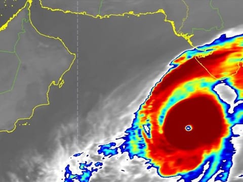
Cyclone Kyarr to weaken, rough seas expected on UAE's east coast
NCM advises residents on east coast to avoid heading out to sea from Tuesday

Dubai: Tropical cyclone Kyarr is expected to gradually weaken over the next 48 hours from but will cause rough seas and possibly storm surges in the UAE’s east coast from Tuesday to Thursday.
The National Centre of Meteorology (NCM) at 1pm on Monday said Kyarr is expected to gradually weaken from a category four cyclone to category three and two in 48 hours, with estimated wind speeds of 170-km/h to 200-km/h.
Kyarr is currently at the centre the Arabian Sea, at latitude 18.4 degrees north and longitude 64.8 degrees east, and is moving at a speed of 12km/hr. the cyclone is packed with windspeeds at the centre of around 230-km/h to 240-km/h, accompanied by intense convective rain clouds.
The cyclone will continue to move in the west-northwest direction across the Arabian Sea.
NCM has advised residents living over the eastern coast to not head out to the sea as it will be rough from Tuesday to Thursday and storm surges could occur during high tide over some areas in the east coast.
NCM said Kyarr is expected to weaken to a category one cyclone and change course by Wednesday at 4pm, moving west-southwest as it moves towards south Oman.
It will further weaken to a tropical storm category by Saturday with speeds of 63-km/h to 118-km/h.
Based on reports from the Met Office of Oman, Kyarr was 760-km away from the closest point on the Omani coast.
The met office is expecting for Kyarr to possibly move southwest closer to the coast, specifically the Dhofar Governorate on the border of Yemen, Ash Sharqiyah South Governorate, over the next 48 hours.
Kyarr is packed with heavy rain and thunderstorms with strong winds. The cyclone will have an indirect impact on the Arabian Sea towards Oman by Monday night with up to six-metre waves and moderate to rough waves in the Oman Sea by up to three metres, the Oman met office warned.
Low-lying coastal areas in Oman could get flooded due to the storm surges.
What is a storm surge?
A storm surge is an abnormal rise in water level due to a storm. This results in extreme flooding in coastal areas, especially when storm surges happen during normal high tide.
Before the emergency:
Stay calm and stay away from potential affected coasts.
Avoid heading out to sea.
Sandbags are a valuable tool to prevent water from entering homes. Coordinate with local emergency officials on this.
Check availability of essential supplies such as food, water, medicine, radio, flashlight and batteries.
If authorities announce a mandatory evacuation, make sure to head to areas determined by emergency officials. But before leaving, ensure all your doors, windows, utilities are closed.
Follow official weather bulletins and reports.
After the emergency:
If you were evacuated, only go back to your house once authorities have allowed you to.
Wear protective clothing and shoes to avoid injuring yourself from the debris, especially broken glass.
Do no use utilities, like gas and power, without checking their condition first. Check for possible leaks or cut electrical wires.
Avoid standing near power lines.
Water supply may be contaminated so have some clean water on hand.
- with inputs from Roudha Mejren, Trainee Reporter


