'Supertyphoon' Rosal accelerates — gale warning up over Luzon, Visayas seas
Super Typhoon Rosal triggers gale warnings across Luzon and Visayas seas
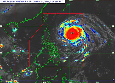
MANILA: Super Typhoon Rosal accelerated while moving over the Philippine Sea east of Northern Luzon on Wednesday, prompting PAGASA to maintain a gale warning over the northern and eastern seaboards of Luzon and the eastern seaboard of Visayas.
As of 5 am, Rosal’s centre was estimated at 990km east of Northern Luzon.
It was forecast to move west-northwestward on Wednesday, then northwestward until Friday morning, before recurving northeastward by Sunday.
Get it: Fast, verified news for FREE ... download the Gulf News app — simply click here
The typhoon is expected to be closest to Extreme Northern Luzon between Thursday and Friday afternoon, before exiting the Philippine Area of Responsibility by Friday evening or early Saturday.
Rain, wind warnings
Weather bureau PAGASA said heavy rainfall may still affect areas outside the forecast cone and urged the public to monitor Weather Advisory No. 3.
Wind Signal No. 1 remains raised over parts of Luzon, with minimal to minor impacts possible. PAGASA said the highest signal that may be raised during Rosal’s passage is Signal No. 2 or 3.
Strong to gale-force gusts are expected Wednesday over Ilocos Region, Cordillera, Cagayan Valley, Bicol, Romblon, Eastern Visayas, Siquijor, Bohol, Northern Mindanao, Caraga, Davao Region and Sarangani.
On Thursday, gusty winds may affect most of Luzon and Visayas, as well as parts of Mindanao, including Zamboanga del Norte, Agusan del Norte, Surigao del Norte, Dinagat Islands and Davao Oriental.
Dangerous seas
PAGASA warned of very rough seas of up to 8 meters off Batanes and the northern and eastern seaboards of Cagayan, including the Babuyan Islands.
Seas of up to 6 meters are expected off the remaining Cagayan seaboard and Isabela, while waves may reach 5 meters off northern Aurora and the northern and eastern seaboards of Catanduanes.
Sea travel is risky for all vessel types. PAGASA ordered mariners to remain in port or seek shelter, while operators of small craft and motorbancas were told not to sail.
Rosal may further intensify within the next six hours before weakening into a typhoon on Thursday and a severe tropical storm by Sunday.


