Philippines: Typhoon 'Francisco' threatens parts of Luzon
Enhanced monsoon to bring strong winds, rough seas across wide swath of PH
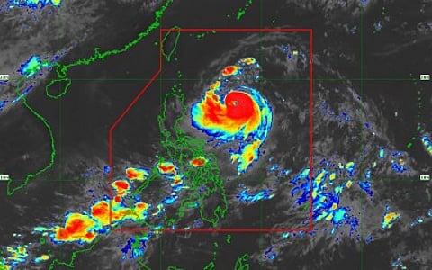
Manila: Typhoon Francisco intensified rapidly Monday as it moved over the Philippine Sea east of northern Luzon, prompting forecasters to keep Tropical Cyclone Wind Signal No. 1 in parts of Cagayan and Batanes while warning of heavy rains, strong winds and rough seas.
The Philippine Atmospheric, Geophysical and Astronomical Services Administration (PAGASA) said in its 11 a.m. bulletin that Francisco was packing maximum sustained winds of 155 kilometers (96 miles) per hour and gusts of up to 190 kph (118 mph).
Get updated faster and for FREE: Download the Gulf News app now - simply click here.
Location
The typhoon was located about 620 kilometers (385 miles) east of Tuguegarao City, Cagayan, and was moving west-northwest at 15 kph (9 mph).
Signal No. 1 remained in effect over Batanes and the northeastern portion of Cagayan, including the towns of Gonzaga and Santa Ana, as well as the eastern Babuyan Islands, including Babuyan, Didicas and Camiguin islands.
PAGASA said Batanes and Cagayan could experience heavy rainfall from the typhoon, raising the risk of flooding and landslides in vulnerable areas.
The southwest monsoon, enhanced by Francisco's outer circulation, is also expected to bring strong to gale-force wind gusts across La Union, Pangasinan, the Calabarzon region, Marinduque, Romblon, Masbate, much of the Visayas, the Zamboanga Peninsula, Misamis Occidental, Lanao del Norte, Camiguin, Surigao del Norte, Dinagat Islands, Davao Occidental and Davao Oriental.
Rough seas
Forecasters also warned of rough to very rough seas along the eastern seaboards of the Babuyan Islands, mainland Cagayan, Batanes, Isabela and northern Aurora.
Small fishing boats and other small vessels, including motorized bancas, were advised to remain in port due to hazardous sea conditions.
PAGASA said Francisco is expected to continue strengthening and could reach its peak intensity by Tuesday. The weather bureau added that it has not ruled out the possibility of the cyclone reaching super typhoon strength.
Although Francisco is forecast to remain well offshore and away from the Philippine landmass, PAGASA said a slight westward shift in its track remains possible and urged residents in affected areas to continue monitoring official weather advisories.


