Flood alert in Manila, hundreds evacuated in Taiwan: Inday (Bavi) soak Luzon as 'big typhoon' worries residents
Warning of flooding risk in and around Manila raised, Taiwan prepares for strong winds
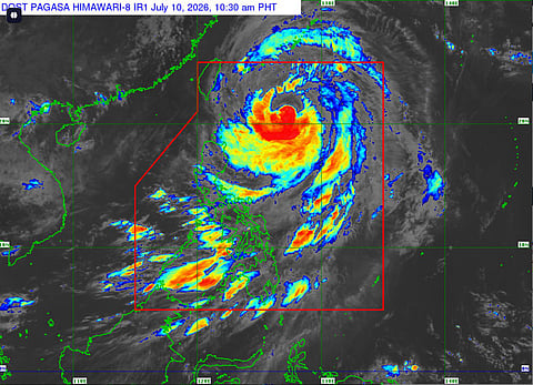
Manila: The state weather bureau Pagasa on Friday (July 10, 2026), issued Heavy Rainfall Warning No. 5 for Metro Manila and nearby provinces while hundreds of people in Taiwan have been evacuated from their homes, and many schools and offices closed, as the biggest typhoon in decades sweeps towards the region on Friday.
Get updated faster and for FREE: Download the Gulf News app now - simply click here
The combined effects of the Southwest Monsoon (Habagat) and distant Typhoon Inday (international name Bavi) is threatening to flood low-lying areas of central Luzon, including Manila.
Typhoon Bavi is expected to pound Taiwan's north and east, as well as Japan's remote southwestern islands, on Friday and Saturday before smashing into China, which has been hit by deadly storms this week.
Locals in the port city of Keelung, which is expected to be one of the hardest hit areas, stocked up on food, taped windows, and stacked sandbags at the entrances to street-level businesses, heeding warnings from authorities to take precautions.
"We're worried," said Samuel Fu, who works in a noodle shop in the coastal district of Bali, near Taipei.
"This is the first time we've experienced such a big typhoon... since we opened the shop," 20-year-old Fu told AFP.
Orange, Yellow alerts
Orange-level warnings (flooding threatening) were in effect for several towns in Bataan and Zambales, while yellow-level alerts (possible flooding in flood-prone areas) covered Metro Manila, Cavite, Batangas and additional parts of Bataan and Zambales.
Light to moderate rains with occasional heavy downpours were expected or ongoing in Laguna, parts of Rizal, Quezon, Bulacan, Pampanga, Nueva Ecija and Tarlac, and could spread to nearby areas.
The warning was issued at 1:30 pm and advised the public and disaster risk reduction offices to monitor conditions, with the next update scheduled for 5 pm.
Pagasa urged vigilance especially in low-lying and flood-prone zones.
Typhoon Inday entered the Philippine Area of Responsibility (PAR) earlier in the week as a "super typhoon" but has since weakened significantly while remaining over the Philippine Sea, well east of Luzon.
As of Friday morning, it continued moving northwestward toward the sea east of Taiwan and is not expected to make landfall in the Philippines, though it may pass close to Batanes.
Monsoon enhanced
Its outer bands and the enhanced monsoon have nonetheless brought widespread rain risks to Luzon, including the National Capital Region.
Wind signals, including No. 1 in some northern areas, remained in place in recent days but the primary concern has shifted to heavy rainfall and flooding.
Residents in affected areas should prepare for potential disruptions, follow local government advisories and avoid swollen rivers or flooded roads.
Resident are urged to check official Pagasa channels for the latest bulletins.
With inputs from AFP


