Monster Super Typhoon Bavi explodes into 285-km/h beast, bears down on Pacific island of Rota in potentially catastrophic strike
Guam and Northern Marianas brace for extreme winds, flash floods and power outages
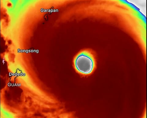
Manila: Super Typhoon Bavi has intensified into one of the most powerful tropical cyclones on Earth this year, reaching Category 5 strength with maximum sustained winds of 285 km/h (180 mph) and an estimated minimum central pressure of 901 millibars, as it bears down on the Mariana Islands with potentially catastrophic consequences.
The latest forecasts from the Joint Typhoon Warning Center (JTWC) indicate Bavi is expected to pass directly over or dangerously close to the island of Rota within hours.
It is expected to bring destructive winds, torrential rain, life-threatening storm surge and widespread power outages.
The storm's eyewall could subject parts of the island to extreme conditions capable of causing severe structural damage and rendering some communities uninhabitable for days or even weeks.
Meteorologists describe Bavi as one of the strongest tropical cyclones of 2026 after undergoing explosive rapid intensification over exceptionally warm western Pacific waters.
The storm strengthened by roughly 100 mph in just 36 hours, fueled by abundant ocean heat and highly favourable atmospheric conditions.
Typhoon and flash flood warnings
Typhoon and flash flood warnings remain in effect across Guam, Rota, Tinian and Saipan, where residents have been urged to shelter in sturdy buildings and stay away from windows as hurricane-force winds, flying debris and flooding become increasingly likely.
Rainfall totals of 12 to 20 inches (300 to 500 mm) are possible, raising the risk of flash floods and landslides.
The approaching cyclone comes less than three months after Super Typhoon Sinlaku devastated the US Pacific territories, killing 17 people and causing an estimated $1.5 billion in damage.
Many communities in the Northern Mariana Islands are still rebuilding from that disaster, with some areas continuing to experience infrastructure and power challenges, making Bavi's arrival especially concerning.
Tracking toward Philippine Sea
Although Bavi is forecast to gradually weaken after interacting with the Mariana Islands, forecasters warn it is expected to remain an extremely dangerous typhoon as it tracks west-northwest toward the Philippine Sea and eventually the vicinity of Taiwan later this week.
Meanwhile, the Philippine Atmospheric, Geophysical and Astronomical Services Administration said Bavi remains outside the Philippine Area of Responsibility (PAR) and poses no direct threat to the Philippines at this time, although it continues to monitor the powerful cyclone's progress.


