So much for the start of summer in UAE
Supposed longest day of the year in terms of daylight plunged into darkness with clouds
Also In This Package

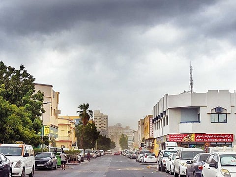
Dubai: Friday was meant to mark the official start of summer, but instead, parts of the country were lashed with unusual June rain.
The National Centre of Meteorology (NCM) issued a red warning to take action and reported moderate to heavy showers on Friday afternoon with Al Madam in Sharjah the most affected by the downpours and strong winds, which blew up dust and reduced visibility to below 1,000-metres, according to NCM tweets.
Nazwa in Sharjah was also heavily affected, as were the Margham, Lehbab and Al Awir areas of Dubai where flooding and surface water wreaked havoc on the roads, as was visible from videos posted on the NCM twitter account.
Moderate to light showers were later reported in Suyoh and Al Gharayen areas of Sharjah before moving to Umm Al Quwain, as the convective clouds swept up through the peninsula from a south-east to a northerly direction.
Videos posted on social media showed heavy rains and high winds with towering black clouds rolling across Sharjah, which was ironic, as June 21, which marks the Summer Solstice and the longest day of the year in terms of daylight, was actually plunged into darkness by the weather system. The NCM issued a warning for dust and reduced visibility of less than 1,000-metres over some eastern areas, while Sharjah Police warned motorists and residents to exercise extra caution on wet roads and in coastal areas, where winds were expected to swell up waves and rough seas.
Dubai Police released similar warnings to motorists urging drivers to maintain a safe distance from the car in front, and to reduce speeds on wet roads to avoid aquaplaning.
A yearly climate report in the UAE from 1977 to 2018 on the NCM website and taken from Dubai’s Automatic Weather Station records showed negligible mean average levels of rainfall far below that of even one millimetre, making Friday’s weather a freak occurrence.
Indeed while April and November hover just below average rainfalls of five millimetres, the summer months of May, June, July, August, September and October are usually dry.
Eastern areas are, however, slightly more used to summer rains, given their proximity to the mountains, which push up clouds coming in from the east off the Gulf of Oman and force the water vapour that these clouds carry to cool in the higher air before turning into water droplets.
There’s expected to be no let-off during the coming days either. Saturday and Sunday will see more chance of afternoon rain caused by convective clouds with light to moderate winds from the north east and west causing gusts of 18-28km/hr, reaching 38km/hr, with moderate seas.
Although the chance of rain will fade by Monday and Tuesday, winds and subsequent dust levels are expected to persist and even increase to reach up to 40km/hr in some areas. Seas will be slight to moderate on Monday, turning from moderate to rough by Tuesday.
Temperatures will range from highs of 35 to 39 degrees Celsius on the coast to lows of 24-29 with humidity levels of 65-85 per cent in the maximum and 20-40 per cent in the lows. Internally, temperatures will linger at highs of 39 to 43 degrees Celsius and lows of 23-29 degrees, with humidity rates of 60-80 per cent high and 15-35 per cent low. Mountainous regions will see high temperatures of 28-35 and lows of 21-26 degrees Celsius with humidity highs of 50-70 per cent and lows of 15-25 per cent.


