First photo taken by KhalifaSat presented
High resolution snapshot of the iconic Palm Jumeirah is the first photo taken by the UAE’s first satellite
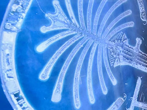
Dubai: Emirati engineers at the Mohammad Bin Rashid Space Centre (MBRSC) on Monday presented to the media the first official photo taken by the KhalifaSat — that of the Palm Jumeirah in Dubai — signalling the beginning of its five-year Earth imaging journey in space.
Amer Al Sayegh, KhalifaSat Project Manager, on Monday showed with his team the high resolution snapshot of the iconic Palm Jumeirah taken by the UAE’s first satellite made from scratch at MBRSC’s clean room in Dubai.
The image was taken at 1.32pm on October 31 when KhalifaSat passed over Dubai.
Ammer Al Mheiri, Manager of the Image Processing Section at MBRSC, said the first two test shots of Dubai were of the Arabian Gulf and the World Islands — but they were not processed as they did not meet the imaging criteria.
But when an image of the Palm Jumeirah was beamed back, it made the cut.
The team processed the image and presented it to the His Highness Shaikh Mohammad Bin Rashid Al Maktoum, UAE Vice President and Prime Minister and Ruler of Dubai; His Highess Shaikh Mohammad Bin Zayed Al Nahyan, Crown Prince of Abu Dhabi; and Shaikh Hamdan Bin Mohammad Bin Rashid Al Maktoum, Dubai Crown Prince and Chairman of MBRSC, on Saturday.
Tense moment
The engineers involved in the launch also shared the tense and emotional moments at the Tanegashima Space Centre on October 29 during the satellite launch.
“This is the fruit of our 12 years of labour. At that moment, all our hard work through the years flashed back through our minds,” Abdullah Harmoul, Launch Manager of KhalifaSat, said.
The KhalifaSat will continue to take images of the Earth and provide them for free to use by UAE government entities and universities.


