Philippines: Tropical depression ‘Verbena’ seen intensifying into storm
Located east of Mindanao, Verbena seen gaining strength within 36 hours
Manila: A tropical depression east of the Philippines could turn into a tropical storm in the next 36 hours, weathermen warned.
In its latest advisory, the weather bureau Pagasa on Monday (November 24, 2025, 11am) issued Tropical Cyclone Bulletin No. 3 for Tropical Depression Verbena (no international name assigned yet).


Currently located east of Mindanao, Verbena maintains its intensity with maximum sustained winds (MSW) of 55 km/h as it approaches the Caraga Region.
The system is forecast to move west-northwestward, potentially intensifying into a tropical storm within the next 36 hours.
Minimal wind signals are in effect across affected areas, with risks of heavy rainfall and enhanced winds in eastern Philippines.
Tropical cyclone wind signals (TCWS)
As of Bulletin #3, TCWS #1 (strong winds of 39-61 km/h, minimal to minor threat) is hoisted over the following areas, primarily in eastern Mindanao and Visayas:
Caraga Region: Surigao del Norte, Dinagat Islands, Surigao del Sur.
Eastern Visayas: Samar, Eastern Samar, Leyte, Southern Leyte.
Other: Portions of Agusan del Norte and Agusan del Sur.
No higher signals (#2 or above) are currently in effect, reflecting Verbena’s depression status.
However, upgrades to TCWS #2 are possible by November 25 if intensification occurs. Public advisories emphasise preparedness in signal areas, with lead times of 12-24 hours.
Current status
Location: As of 11am on November 24, 2025, the center of Verbena is estimated approximately 300-400 km east-southeast of the Caraga Region (based on satellite imagery and forecast positioning).
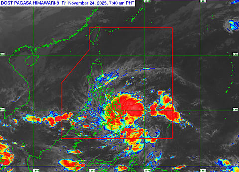
Intensity: MSW of 55 km/h near the center, with gusts up to 70-80 km/h. Central pressure is approximately 1002 hPa. The system remains a tropical depression but shows organized convection as depicted in infrared satellite imagery (Himawari-IR1 at 10:40 AM PHT), with a developing low-level circulation and scattered rainbands.
Movement: West-northwestward at 15-20 km/h.
Size: Gale-force winds (39-61 km/h) extend up to 100 km from the center; the system affects an area of about 200 km in diameter.
Verbena entered the Philippine Area of Responsibility (PAR) earlier on November 24 and is expected to bring initial impacts to eastern Mindanao within the next 12 hours.
Forecast track, intensity
Pagasa’s forecast track indicates Verbena will continue west-northwestward, making closest approach to the Caraga Region and eastern Visayas before curving westward toward Palawan and eventually exiting the PAR by November 27.
The system is projected to intensify gradually due to “favorable environmental conditions”, Pagasa warned, including low vertical wind shear and warm sea surface temperatures (>28°C);
Key forecast highlights:
Landfall Potential: Possible landfall or close approach over Dinagat Islands or Surigao del Norte within 12-24 hours, followed by passage near Negros Occidental and Palawan.
Intensity Outlook: Expected to reach tropical storm status by late November 25, peaking as a severe tropical storm (95 km/h) by November 27 before weakening outside the PAR due to cooler waters and increasing shear.
Confidence: Medium; track uncertainty cone spans 100-200 km by 72 hours.
Wind hazards
Gale-Force Winds: Possible in exposed coastal and upland areas of Caraga and eastern Visayas, enhanced by the system's periphery.
Potential Impacts: Minor damage to light structures, power outages, and risks to agriculture; significant threats if intensification exceeds forecasts.
Heavy rainfall
24-Hour Outlook: 50-100 mm over Caraga, eastern Visayas, and Bicol Region, leading to moderate risks of flooding and landslides in low-lying and mountainous areas.
Cumulative (Next 72 Hours): Up to 200-300 mm in Caraga, potentially triggering TCWS-related evacuations.
Storm surge
Low risk (<1.0 m above normal tides) along eastern Mindanao coasts; monitor for updates.
Marine hazards
Seas: Rough to very rough (2.5-4.0 m) over the eastern seaboard of Mindanao and Visayas; small vessels advised to stay in port.
Gale Warning: In effect for northern and eastern Philippines seaboards.
Recommendations
Public: Residents in Caraga and eastern Visayas should secure properties, avoid flood-prone areas, and heed local DRRM office alerts.
Monitor PAGASA updates every 3 hours.
Authorities: Activate preemptive evacuations in high-risk barangays; prepare for potential signal upgrades.
Next Update: PAGASA will issue the next bulletin at 2pm on November 24, 2025.


