Mekunu weakens into deep depression
No direct impact of cylcone on UAE as Mekunu weakens following landfall in Dhofar
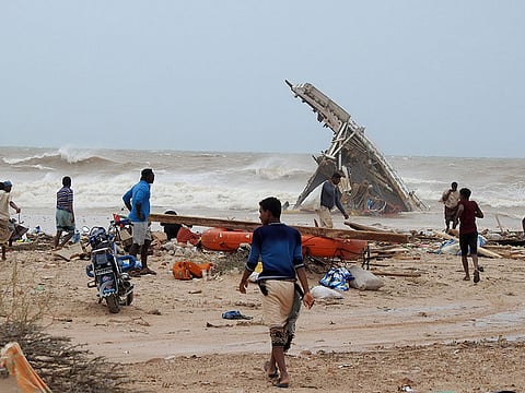
Abu Dhabi/Manama: Tropical cyclone Mekunu, which made landfall in Oman’s Dhofar region early on Saturday, has weakend into a deep depression, the UAE’s National Centre of Meteorology said on Saturday afternoon.
Alhough Mekunu dropped in intensity from Category One storm after making landfall in Salalah, thundershowers accompained by strong winds have continued over Dhofar and Al Wusta regions of Oman.
A satellite image shows Cyclone Mekunu in the Arabian Sea, in Oman on Saturday. AP
The Arabian Sea continues to be rough with waves ranging between four to eight metres high, with an estimated windspeed of around 126kph to 144 kph, according to the UAE’s National Center of Meteorology.
According to met officials at NCM, Mekunu will continue moving towered the northwest from the current location and it is very likely to weaken into a tropical depression during the next 6 hours, with wind speed 40 kph to 50 kph.
The offcial added that the UAE will have no direct impact of the cyclone as it moves northwest.
“As predicted by the National Centre of Meteorology, the tropical cyclone will not reach the UAE. However, the medium and high clouds and the moist air mass may lead to rainy convective cloud formations in the eastern and the southern parts of the country, which is associated with fresh winds causing blowing dust or sand, leading to hazy and cloudy weather,” said a NCM official.
He added that the NCM is monitoring the weather conditions 24/7.
“Announcement with updated information regarding the cyclone will be issued accordingly. The Centre urges the public to keep following updates, reports, forecasts issued by the NCM and avoid rumours issued by non- professional entities,” said the Met official.
Meanwhile, Mekunu may also impact parts of Saudi Arabia, starting Saturday dawn until Tuesday.
Southern parts of the eastern desert of Rub Al Khali (the Empty Quarter) and the eastern parts of Najran will be affected by torrential rains that may lead to flash floods and active winds of up to 75 km/h, in addition to dusty weather, the kingdom’s General Authority of Meteorology and Environment Protection (GAMEP) said.
The authority called on citizens and residents to follow daily weather reports and alerts issued on the official website and on social media, stressing that there could be changes in the situation over the four days.
The Eastern Province Civil Defence and its subcommittees have been meeting in Dammam to follow up on the expected turbulent weather conditions.
In its forecast for Saturday, GAMEP warned the impact of the tropical storm will begin with heavy rainfall and strong and dust winds that will result in zero horizontal visibility in the eastern parts of Najran (Al Kharkhir) and the southern parts of the Eastern Province.
Surface dust winds will reduce visibility over Tabuk, Madinah, Makkah, Eastern Province and Riyadh as well as in the Najran regions. Storm and rain clouds are expected over Jazan, Asir, Baha, GAMEP said .
Sign up for the Daily Briefing
Get the latest news and updates straight to your inbox


