Philippines: Typhoon Paolo (Matmo) gains strength, Signal No. 3 up in 10 areas, multiple flights cancelled
Evacutions underway as storm forecast to turn into a severe tropical storm by October 3
Manila: As the Philippines recovers from a barrage of storms, residents in northern Luzon are facing yet another tropical cyclone.
Tropical Storm Paolo, the 16th storm to enter the country’s area of responsibility (PAR) in 2025, formed east of Catanduanes on October 1, intensified as it barreled westward, and was expected to hit land in northern Philippines on Friday (October 3).
Residents of vulnerable northern barangays evacuated, and local governments are stockpiling relief goods.
PAGASA urges residents to stay updated via official channels and avoid flood-prone areas, emphasising that even a slight track deviation could amplify impacts.
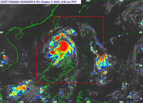
Track and intensity forecast
Paolo's track has been consistently westward to west-northwestward over the Philippine Sea. Key positions include:
October 1, 10:00 PM: 705 km east of Infanta, Quezon, moving at 20 km/h.
October 2, 4:00 AM: 705 km east of Infanta, Quezon (initial tropical storm status).
October 2, 11:00 AM: 575 km east of Infanta, Quezon, winds at 75 km/h.
October 2, 10:00 PM: 320 km east of Baler, Aurora, accelerating to 30 km/h.
October 3, 5:00 AM: 150 km east of Casiguran, Aurora.
October 3, 7:00 AM: Over coastal waters of Dilasag, Aurora, moving west-northwest at 25 km/h.
Landfall occurred over Dilasag, Aurora, or Dinapigue, Isabela, on the morning of October 3.
Post-landfall, Paolo is forecast to traverse northern Luzon, weaken due to terrain interaction, and emerge over the West Philippine Sea by late October 3.
It will exit the PAR by Saturday morning, October 4, potentially looping in the West Philippine Sea thereafter.
Intensity is expected to peak near typhoon strength before landfall, with possible brief typhoon status. Impacts and WarningsWind SignalsPAGASA hoisted escalating wind signals across Luzon:
October 1 (11:00 PM): Signal No. 1 over northern Catanduanes and additional eastern areas.
October 2 (5:00 AM): Signal No. 1 expanded to 22 provinces; No. 2 in southeastern Isabela, northern Quirino, and northern Aurora.
October 2 (Evening): Signal No. 3 over parts of Isabela, Quirino, and Aurora.
October 3 (Morning): Signal No. 3 expanded to over 10 areas in northern Luzon, including Cagayan, Isabela, Aurora, and Quirino; No. 2 in additional provinces like Ilocos Norte and Nueva Vizcaya; No. 1 in wider regions.
Signal No. 3 indicates winds of 61-120 km/h, capable of causing minor to moderate damage to light structures.
Rainfall and flooding
Paolo's trough and outer bands brought scattered rains to Metro Manila, Cordillera, CALABARZON, Cagayan Valley, Bicol, and parts of Visayas from October 2.
On October 3, heavy rainfall (100-200 mm) is forecast for Isabela, Quirino, Nueva Vizcaya, Aurora, and Quezon, raising risks of flash floods and landslides.
A Rainfall Advisory was issued for NCR, Pampanga, Batangas, Tarlac, Cavite, Rizal, Metro Manila, Nueva Ecija, Bulacan, and Laguna, with light to moderate rains occasionally becoming heavy.
Storm Surge
Moderate to high risk of life-threatening storm surges (1-3 meters) was warned for coastal areas of Ilocos Norte, Ilocos Sur, Cagayan, Isabela, Aurora, and Quezon within 36 hours of October 2. PAGASA emphasized evacuation for low-lying coastal communities. Disruptions
Education and Work: Classes and government work suspended in Ilocos Norte, Aurora, Isabela, Quirino, and other affected provinces on October 3. 2 sources Midterm exams were postponed in some areas.
Transportation: Multiple flights cancelled on October 3, affecting over 1,500 passengers to/from Tuguegarao, Cauayan, and Laoag (e.g., Cebu Pacific 5J 504-509, Philippine Airlines PR 2014-2019, 2196-2199). Rough to very rough seas (2.5-4.5 m) along northern and central Luzon seaboards.
Public Alerts: Sirens sounded in Dilasag, Aurora, for three minutes on October 3 morning as a landfall warning. Local DRRMOs urged residents to prepare and monitor updates.
As of October 3 morning, no major damage reports were available, but impacts are ongoing.
Paolo is expected to exit the PAR by October 4 morning, potentially heading toward Guangdong Province in China, but its Philippine leg could still evolve rapidly.


