Philippines: ‘Unusual’ tropical depression intensifies, changes course
Extreme rapid intensification' possible: Thunderstorm alert raised over Manila
Manila: A tropical cyclone in the western Pacific barreling toward the Philippines has changed course — following an unusual “C” curve — while gaining intensity. One climate scientist called this movement “extraordinary”.
Government forecasters, who tracked storm “Goring” (international code: Saola) moving south-southwestward early on Friday, raised the possibility of an extreme rapid intensification (ERI) enough for it to become a "supertyphoon”.
'Quasi-stationary'
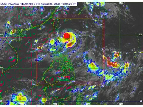
Pre-dawn on Friday, the weather system has rapidly intensified into an 85-km/h tropical storm as it remained “quasi stationary” along the eastern coastal waters of the Balintang and Bashi Channels in northern Luzon.
It is seen packing maximum sustained winds of near the centre and gustiness of up to 105 km/h. Northern Cagayan province is now placed under Tropical Cyclone Wind Signal (TCWS) #1.
'Extraordinary' motion
The Philippine Atmospheric, Geophysical, and Astronomical Services Administration (Pagasa), in a 11am bulettin on Friday, stated: "Goring continues to intensify while moving south-southward" bringing severe winds in areas where Signal No. 1 is hoisted.
Filipino weatherman Mika Padua said that given the latest weather data, Goring/Saola could take an “extraordinary motion” in the next 48 hours, beginning with a slow “southward drift” for the next 24 hours, and then a sudden south-to southeast track towards the coastal waters parallel to Isabela-Aurora shorelines on Saturday (August 26) through Sunday.
Pagasa, in addition, predicts that after moving south-southwestward, Goring will "loop northwards" before turning to the northwest on Tuesday towards the Luzon Strait.
Warning to residents
The presence of Goring, plus its trough is expected to enhance the southwest monsoon across a huge swath of the country — Western Visayas, MiMaRoPa, and Luzon on Friday.
Residents were advised to take precautionary measures against the impacts associated with weather-induced hazards, including flash floods, storm surges, high winds and landslides that will be brought about by these systems.
“Goring continues to intensify while moving south southwestward,” the Pagasa weather bureau stated in a tweet. It was earlier tracked moving north-northward.
At 10.45am Manila time, government forecasters raised the thunderstorm advisory No. 1, predicting moderate to heavy rainshowers with lightning and strong winds are expected over Metro Manila, Zambales, Bataan, Laguna, Quezon, Tarlac, Nueva Ecija, Batangas within the next 2-3 hours.
The above conditions are being experienced in Cavite (Maragondon, Naic, Trece Martires, Dasmarinas), Rizal (Binangonan, Cardona) which may persist within 2 hours and may affect nearby areas.
“Rapid intensification”
Following a minor weakening on the evening of Thursday, August 24, Goring's maximum sustained winds rebounded from 65 km/h to 85 km/h.
Pagasa predicts that the storm might reach its peak strength as a typhoon by the evening of Sunday, August 27, and maintain that level of intensity.
The center of Tropical Storm Goring was estimated, based on all available data, at 225 km East Southeast of Basco, Batanes or 270 km East of Calayan, Cagayan (19.7 °N, 124.0 °E ).


