Philippines: Signal # 2 areas named as tropical storm Basyang (Penha) moves toward Eastern Mindanao
Storm Basyang expected to make landfall in Surigao del Sur Thursday night or early Friday
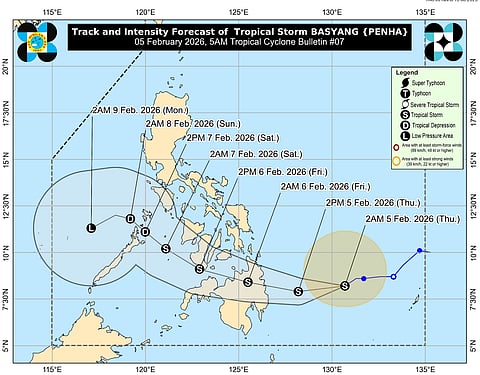
Manila: Tropical storm Basyang (international name: Penha), has maintained its strength while moving toward Eastern Mindanao.
Weather trackers show the storm's projected path from its current position southeast of the Philippines, curving westward across Mindanao, then northwest toward the Visayas.
Signal #2
Tropical Cyclone Wind Signal (TCWS) #2, where 62-88 km/h winds could cause light to moderate damage to structures and vegetation, is hoisted over the following areas:
Parts of Eastern Samar
Samar
Biliran
Leyte
Southern Leyte
Bohol
Cebu
Siquijor
Negros provinces
Guimaras
Iloilo
Capiz
Aklan
Antique, and
Several Mindanao areas
Signal #1
TCWS #1 covers additional regions in Mindanao, anticipating 39-61 km/h winds.
Warnings include heavy rainfall, up to 2-metre storm surges in coastal areas like Dinagat Islands and Surigao provinces, and gale-force gusts from the Northeast Monsoon affecting much of the country.
Residents are advised to prepare for flooding, secure properties, and avoid sea travel, as small craft face risks in rough seas.
As of the latest update from Pagasa severe weather bulletin #7 (at 7:52 AM PST, February 5), Basyang's centre was seen at 440 km east of Hinatuan, Surigao del Sur, with maximum sustained winds of 65 km/h and gusts up to 80 km/h.
The weather system is moving west-southwest at 15 km/h but expected to shift westward, potentially intensifying slightly before landfall in Surigao del Sur tonight or early tomorrow.
Post initial landfall, it may cross Bohol Sea, southern Negros Oriental, Sulu Sea, and northern Palawan by Saturday.


