Caution: Road closures to take place in UAE for cycling tour
The inaugural UAE Tour will affect these routes from February 25 to March 2, 2019
Also In This Package

Dubai: Motorists across the country may face diversions and delays on their daily routes due to the upcoming six-day road closures set to take place at the end of February.
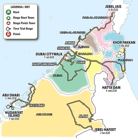
The road closures, according to organisers, will take effect during the cycling race UAE Tour from February 25 to March 2, 2019, where professional cyclists will cover a total distance of 1,090 kilometres across the seven emirates.
The first stage, on February 24, will not be affected by any road closure as it will take place on traffic-free cycle path loops.
The second stage on February 25 will see participants cycle for 184 km across Abu Dhabi, starting from Yas Mall towards Khalifa Port. Cyclists will then return to the city along Channel Street and then pedal their way through from Yas Island to Saadiyat Island, past the Louvre Abu Dhabi and the Corniche until the finish line at Abu Dhabi Breakwater.
The third stage – the first of the UAE Tour’s two mountain stages – will be held at Al Ain-Jebel Hafeet for 179 km.
The route around Al Ain takes in many of the landmarks, including Al Ain Zoo, Al Qattara, Al Hili and Al Ain Oasis, where the final climb will take place at Jebel Hafeet.
The fourth stage will be the longest one of the tournament, taking place in Dubai from Palm Jumeirah to the Hatta Dam that covers 197 km.
“This is another classic route in the Emirates, having been raced before as the most difficult stage of the Dubai Tour, and having remained virtually unchanged since the first edition of that race. Only the start has been modified, departing from Palm Jumeirah,” said organisers.
Stage five will be carried out from Sharjah to Khor Fakkan, where participants will cover 181 km.
After crossing the desert between the University of Sharjah and the University of Khalba, the route follows the coast north through Fujairah, up to the finish line in Khor Fakkan.
The sixth stage will be 180 km long from Ajman to Jebel Jais in Ras Al Khaimah. This is the second of the two mountain stages, and is likely to be the decisive stage of the UAE Tour.
After the departure from Ajman, the route crosses Umm Al Quwain towards Ras Al Khaimah as the race heads directly to the Jais mountain.
The seventh and final stage will be through the streets of Dubai, from Safari Park to Citywalk. Covering a total distance of 145 km, participants will departure from the Dubai Safari Park, and then make their way through Dubai Design District, Mushrif Park, Al Mamzar Beach, Deira, and Rashid Port, up until Jumeirah Road and end at Citywalk.


