NASA's space laser satellite to track ice loss takes off
NASA to measure ice sheet surface elevation across the globe
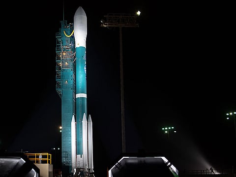
Los Angeles: NASA's most advanced space laser satellite blasted off on Saturday on a mission to track ice loss around the world and improve forecasts of sea level rise as the climate warms.
The $1 billion (Dh3.67), half-tonne ICESat-2 launched aboard a Delta II rocket from Vandenberg Air Force base in California at 6.02am (1302 GMT).
"Three, two one, liftoff!" said a launch commentator on NASA television.
"Lifting ICESat-2 on a quest to explore the polar ice sheets of our constantly changing home planet."
The launch marks the first time in nearly a decade that NASA has had a tool in orbit to measure ice sheet surface elevation across the globe.
The preceding mission, ICESat, was launched in 2003 and ended in 2009.
The first ICESat revealed that sea ice was thinning, and ice cover was disappearing from coastal areas in Greenland and Antarctica.
In the intervening nine years, an aircraft mission called Operation IceBridge, has flown over the Arctic and Antarctic, taking height measurements of the changing ice.
But a view from space - especially with the latest technology - should be far more precise.
The new laser will fire 10,000 times in one second, compared to the original ICESat which fired 40 times a second.
Measurements will be taken every 2.3 feet (0.7 meters) along the satellite's path.
"The mission will gather enough data to estimate the annual elevation change in the Greenland and Antarctic ice sheets even if it's as slight as four millimeters - the width of a No. 2 pencil," NASA said in a statement.
Importantly, the laser will measure the slope and height of the ice, not just the area it covers.
"One of the things that we are trying to do is, one, characterise the change that is taking place within the ice, and this is going to greatly improve our understanding of that, especially over areas where we don't know how well it is changing right now," said Tom Wagner, cryosphere programme scientist at NASA, mentioning the deep interior of Antarctica as one such area of mystery.
The mission is meant to last three years but has enough fuel to continue for 10, if mission managers decide to extend its life.


