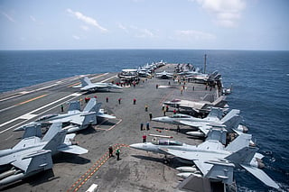
How ships are found, blockaded: US warships set to seal off Iran's ports at midnight (July 15, 2026)
How a vast US naval web quietly throttled Iran’s oil lifeline at Hormuz

A naval blockade is one of the most powerful military tools available short of a full-scale invasion.
It aims to prevent ships from entering or leaving an enemy's ports, disrupting trade, military logistics and energy exports.
The US naval blockade is carried out by large network of ships, aircraft, satellites and intelligence assets, usually led by a US carrier strike group.
Blockade kicks off at midnight: The US Central Command (CentCom) has announced that its forces will resume blockading maritime traffic entering and exiting Iranian ports on July 14 at 4 pm ET (12:00 Midnight in Gulf Standard Time [GST] on July 15).
Why the Strait of Hormuz matters to you and me
The Strait of Hormuz is one of the world's most strategically important waterways.
It's a relatively narrow passage where advanced surveillance, multinational naval forces and concentrated shipping traffic give maritime powers substantial leverage over global trade without needing to physically seal off the entire Gulf.
At its narrowest point, the strait is about 33 kilometers (21 miles) wide. However, ships do not have the entire width available for navigation.
In practice, commercial traffic follows internationally-recognised traffic separation lanes that are only about:
2 miles (3.2 km) wide inbound
2 miles (3.2 km) wide outbound
separated by a 2-mile "buffer zone"
This effectively funnels thousands of ships each year into narrow shipping corridors that are relatively easy to monitor.
The strait connects the Arabian Gulf with the Gulf of Oman and the Arabian Sea.
Countries relying on the passage include:
Saudi Arabia
Iraq
Kuwait
Bahrain
Qatar
the United Arab Emirates
Iran
Around 20% of global petroleum consumption and a significant share of the world's liquefied natural gas exports transit the strait each day.
How large is a blockade area?
Contrary to popular imagination, a blockade is rarely a solid wall of warships.
Instead, it can cover hundreds of thousands of square kilometers.
Capt. Daniel Keeler, commanding officer of the aircraft carrier USS Abraham Lincoln, told CNN's Pamela Brown about the carrier strike group's role during the previous US operation to enforce security in and around the Strait of Hormuz.
The US Navy enforces the maritime blockade on Iran using a force of over 15 warships. The blockade operation involves more than 10,000 US Sailors, Marines, and Airmen. It enforces a strict interdiction on all vessels attempting to enter or depart Iranian ports and coastal areas, while allowing neutral transit through the Strait of Hormuz to non-Iranian destinations.
For a blockade involving Iran, US naval forces may monitor:
the Strait of Hormuz
the Arabian Gulf
Gulf of Oman
northern Arabian Sea
approaches to Iranian ports
Altogether, this operational area can exceed one million square kilometers, although only key shipping routes need constant surveillance.
Warships do not have to sit directly outside every Iranian port.
Instead, they control the sea approaches where commercial vessels must travel.
How are ships found?
Modern navies rely on several overlapping systems.
1. Satellites
Military and commercial satellites monitor:
ship movements
new departures
port activity
cargo loading
Some satellites can even identify changes in ship drafts, indicating whether tankers are loaded with oil.
2. AIS tracking
Nearly every commercial vessel broadcasts an Automatic Identification System (AIS) signal.
AIS transmits:
ship name
destination
speed
heading
identification number
The information is visible to coast guards and naval forces worldwide.
Some sanctioned vessels switch off AIS to avoid detection, but doing so often attracts greater scrutiny.
3. Maritime patrol aircraft
Aircraft such as the:
P-8A Poseidon
MQ-4C Triton drones
MQ-9 Reaper drones
can search vast stretches of ocean using radar and electro-optical sensors.
4. Carrier aircraft
Aircraft operating from carriers like the USS Abraham Lincoln extend surveillance hundreds of miles beyond the horizon.
They identify contacts before surface ships ever encounter them.
5. Radar and intelligence
US destroyers, cruisers and allied warships combine radar data with intelligence from allies and commercial shipping databases.
Everything feeds into a common operating picture shared across the fleet.
How are ships turned around?
Most encounters begin peacefully.
When a vessel approaches a restricted area, naval forces usually:
identify it
contact the bridge by marine radio
verify cargo and destination
issue navigation instructions
Many merchant ships comply immediately.
If a vessel refuses:
patrol ships intercept it;
helicopters may hover overhead;
boarding teams can be prepared.
In higher-risk situations, destroyers or fast patrol craft may physically position themselves to prevent passage.
Only in extreme circumstances would force be used.
What role does an aircraft carrier play?
Although an aircraft carrier is the centerpiece of the strike group, it is not normally the ship stopping merchant vessels.
Instead, it provides:
air superiority
intelligence gathering
reconnaissance
electronic warfare
rapid strike capability
command-and-control
Its aircraft allow commanders to monitor enormous areas of ocean continuously.
Destroyers and cruisers typically perform the direct interception missions.
Can every Iranian port be blocked?
Not necessarily.
Instead of surrounding each port individually, naval planners focus on the sea lines of communication—the routes ships must use.
Major Iranian ports include:
Bandar Abbas
Kharg Island (oil export terminal)
Bandar Imam Khomeini
Bushehr
Chabahar (outside the Strait of Hormuz)
Ships departing these ports eventually converge onto predictable routes where they can be monitored or intercepted.
Why it is so effective
Modern maritime surveillance makes it difficult for large commercial vessels to disappear.
Oil tankers are among the easiest ships to track because of their:
enormous size;
predictable routes;
commercial reporting requirements;
frequent satellite coverage.
Even if a tanker disables its AIS transponder, satellites, aircraft and radar often continue to monitor its movement.
Strategic impact
A blockade does not have to stop every vessel to be effective.
If shipping companies believe vessels face delays, inspections or interception, insurance premiums rise sharply, freight costs increase and some operators choose alternative routes or suspend sailings altogether.
For an oil-exporting nation such as Iran, even partial disruption can significantly reduce export volumes and government revenue while increasing pressure on its economy.
That is why the Strait of Hormuz remains one of the world's most closely watched maritime chokepoints.