Tropical Storm Kalmaegi (Tino) intensifies, threatens central Philippine islands
Forecasts indicate it may reach severe tropical storm category within the next 12 hours
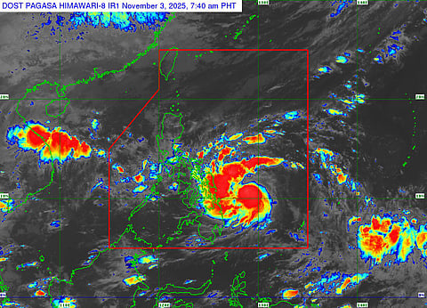
Manila: As of 8am local time on Monday (November 3), Tropical Storm Kalmaegi, locally named "Tino", has intensified into a Severe Tropical Storm (STS) and could reach Typhoon status "within the next few hours", weathermen warned.
Kalmaegi is accelerating on a west-southwestward track, westward toward Eastern Samar.
Updates: (8am Manila time, Monday, 03 Nov 2025)
The potential landfall area: Between Leyte and Southern Leyte by early tomorrow morning.
Rapid Intensification (RI): Kalmaegi (Tino) has the potential to undergo RI due of favourable conditions such as high Oceanic Heat Content (OHC) and very low wind shear environment, as per local bureay Pagasa.
Most global forecast models indicate that Kalmaegi (Tino) could develop into a severe tropical storm, likely comparable to a Category 3 or 4 hurricane.
48-hour outlook: Kalmaegi (Tino) is forecast to turn more westward and is expected to intensify into a high-end Category 1 Typhoon later on Monday.
By early Tuesday morning, Kalmaegi (Tino) core is expected to make landfall in the area between Silago and Abuyog in Leyte and will traverse Leyte Island, passing over the Camotes Islands.
It is expected to move west-southwestward at 30 kph, possibly reaching typhoon strength with winds of 150-165 km/h, near its peak intensity upon landfall.
The storm may intensify into a typhoon before making landfall between Monday evening and early Tuesday morning over Eastern Samar or Dinagat Islands.
Pagasa warns of a high risk of life-threatening storm surges, with surges expected to reach more than 3 meters in Eastern Samar and between 2.1 to 3 meters in Dinagat Islands, Leyte, and other areas.
Tino is forecast to traverse Visayas and northern Palawan before exiting the West Philippine Sea around Wednesday.
The overall forecast suggests that Tino will likely remain a typhoon throughout its passage, with its interaction with land possibly causing slight weakening but not downgrading its intensity.
Intensification
This storm's intensification and movement pose significant concern for areas along its projected path, prompting continuous monitoring and preparedness measures.
By around 8am on Tuesday, the storm will be in the vicinity of Danao City, Cebu, and will move across Northern Negros, passing over or very close to Bacolod City and Guimaras between 10 am and 12 pm.
By Tuesday afternoon, it will be along the coastal waters of Iloilo City, traversing the southern tip of Iloilo and Antique.
By early Wednesday morning, Kalmaegi/Tino is forecast to pass over or very close to Linapacan Island, Palawan, with a possible re-strengthening to 140 km/h sustained winds as it moves over the West Philippine Sea.
Same pattern as Ragasa
Severe Tropical Storm Tino follows a pattern similar to Typhoon Ragasa, which struck the Philippines in September 2025, causing widespread evacuations and infrastructure damage.


Key points to know:
Kalmaegi/Tino is expected to reach typhoon strength before landfall, with peak winds forecasted at around 167 km/h (104 mph) by late November 3 or early November 4.
The Philippines typically experiences around 10 typhoons annually, with August being the most active month, but recent patterns show a concerning trend of late-season storms.
Pagasa has been monitoring Kalmaegi closely, refuting earlier viral claims of a "super typhoon" but acknowledging the potential for significant impact.


