Philippines: 'Potential supertyphoon Kristine' moves in
11th storm to enter country in 2024: Signal No. 1 is up over 15 provinces
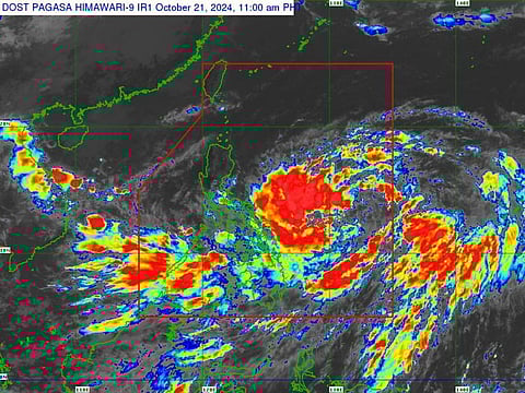
Manila: Tropical depression 'Kristine' (international code: TD22W) is moving in from the vast Pacific Ocean, and may develop into a 'super typhoon' affecting a wide swath of the country, the weather bureau warned on Monday.
Emergency workers and residents in up to 5,000 "barangays" (villages) were urged to prepare for the weather disturbance, the 11th storm to enter the country this year so far.
The Philippine Atmospheric, Geophysical, and Astronomical Services Administration (Pagasa) stated that the storm’s thick western outer rain bands are expected to dump severe rains in Bicol Region and Eastern Visayas later on Monday through Tuesday (October 21 to 22), according to weathermen.
Tropical Cyclone Wind Signal (TCWS) No. 1 is currently raised over 15 areas nationwide.
Floodwaters have started surging due to the heavy rains brought by Kristine in Bantac, Magpet, North Cotabato on Monday, October 21, local media reported.
Moderate to heavy rain with lightning and strong winds are also expected in Laguna, Rizal and Batangas on Monday afternoon, according to Pagasa.
The bureau urged emergency workers and residents to prepare for potential impacts.
Heavy rains expected
Kristine is expected to bring heavy rains across Luzon, while the Visayas and Mindanao will experience light to occasional moderate rainfall.
Class suspensions
Classes at all levels were suspended on Monday afternoon after Tropical Cyclone Wind Signal No. 1 was raised in 15 areas nationwide.
Location and strength (as of 10 AM, October 21):
Kristine was spotted 870 km east of Eastern Visayas.
It has maximum sustained winds of 55 kilometers per hour (kph) and gusts up to 70 kph, moving west-southwest at 30 kph.
Super typhoon
Pagasa's Weather Division Chief, Juanito Galang, mentioned that the development of super typhoons is more common toward the end of the year. Thus, they are not ruling out this possibility for Kristine.
Galang also highlighted similarities in Kristine's track to Super Typhoon Lawin (international name: Jelawat) of 2012, which entered the Philippine Area of Responsibility (PAR) from the Pacific and moved west-northwestward.
Monitoring
"We are not eliminating the possibility of a super typhoon because it is at the end of the year when storms usually reach the super typhoon category," Galang stated in mixed Filipino and English.
Kristine is currently expected to affect Northern Luzon, similar to Lawin, though its course may still change within the next 24 hours.
"We are waiting until tomorrow to see if the effect descends on Central Luzon," he added.
Alert
Despite its distance from the country, Tropical Cyclone Wind Signal No. 1 has been raised in 15 areas nationwide to prepare for potential impacts.
Classes for all levels were suspended on Monday afternoon in areas under Signal No. 1.


