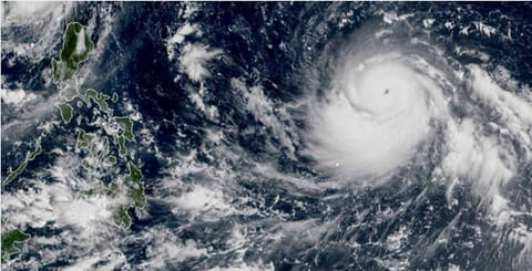
Philippines braces for arrival of 260 km/h 'supertyphoon' Mangkhut
Superstorm expected to make landfall with speeds of up to 260km/h; 1.2m hectares of rice farms could face severe damage

Manila: Authorities in northern Philippines were on high alert on Tuesday, as powerful typhoon Mangkhut was expected to bring heavy rains, landslides and floods to the region — and threatening its rice-growing regions just two months after floods triggered by a previous storm.
Mangkut, which is expected to enter Philippine territory on Wednesday evening, will be one of the most powerful typhoons to visit the country this year.
Currently, it packs 170 km/h winds near the center, with gusts up to 210 km/h.
Huge swathes of farmland in the central Luzon provinces of Pangasinan and Tarlac sustained huge losses due to flooding two months ago. This image was shared on Facebook by Philippine Department of Agriculture Secretary Manny Piñol. The same central plains are now threatened by the supertyphoon Mangkhut. Such disasters prevent the Philippines from reaching its goal of becoming self-sufficient in rice. Facebook
“Mangkhut [known in the Philippines as ‘Ompong’] has further intensified while continuing to move westward,” the National Disaster Risk Reduction and Management Council (NDRRMC) said on Tuesday.
The storm is expected to carry maximum sustained winds of up to 170 kilometres per hour near the centre, and currently is packing gusts of 210km/h. This could increase further into a "supertyphoon" level.
A supertyphoon is a storm that reaches sustained windspeeds of at least 240 km/h (150 m/h).
The weather disturbance was moving west towards the Philippines at a fast clip of 25 km/h.
The Philippine Atmospheric, Geophysical and Astronomical Services Administration (Pagasa) warned that the wins carried by Mangkut will intensify in the coming hours.
The typhoon is expected to dump moderate to heavy rains in the northeastern provinces of Cagayan, Isabela, Apayao, Kalinga, Abra, Ilocos Norte and Batanes.
According to Armed Forces Civil Relations Chief, Col Noel Detoyato, the military has been placed on standby for rescue efforts.
“The military continues to be on a red alert status,” he said.
Mangkhut is expected to develop into a Super Typhoon.
260 km/h sustained windspeed
“Upon entering the country, the typhoon’s maximum sustained winds may reach 210 kph and gusts of 260 kph,” Pagasa said.
The Philippine Coast Guard (PCG) has alerted districts and stations in northern and central Luzon to brace for the possible effects in maritime activities once it enters the Philippines.
Disaster preparedness
Coast Guard Commandant Admiral Elson Hermogino directed all district commanders in areas expected to be hit by the super typhoon to ensure the readiness of all assets and personnel to respond during emergency situations.
He also directed Coast Guard units to remind and prevent all types of inter-island vessels from sailing in the areas, where public storm signal will be possibly hoisted by the Pagasa
1.2m hectares of rice farms could be hit
Agriculture Secretary Manny Pinol said an estimated 1.2-million hectares of farms planted to rice and corn which are about to be harvested may be affected if Mangkhut continues on its course and slams into Northern Luzon.
“The Field Operations Office of the Department of Agriculture projected that in a worst case scenario rice crops some of which are ready for harvest in the Cordillera Region, Ilocos Region, Cagayan Valley could suffer up to P7 billion (Dhs 477 million) in damages.
“In a worst case scenario, an estimated 893,000 hectares of rice farms in the four regions will be affected by Mangkhut,” Pinol said.


