10 strongest typhoons to hit the Philippines in recent years: What's next?
'Mawar' packs gusts of up to 265km/h, moving in from western Pacific

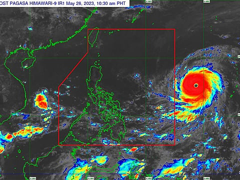
Manila: Super Typhoon 'Mawar' is still gaining strength as it barrels toward the Philippine Atmospheric, Geophysical, and Astronomical Services Administration's (Pagasa) region of meteorological surveillance and toward the west-northwest over the Philippine Sea on Friday.
Meteorologists say Mawar packs a strength of 215 km/h, with gustiness of up to 265 km/h. Heavy to intense rainshowers with lightning and strong winds are expected. People are also advised to take precautionary measures against the impacts of flash floods and landslides.
Based on the 4 pm bulletin on Friday (May 26, 2023), weather satellites spotted 'Mawar' travelling at a speed of 25 km/h while being 1,725 kilometres east of Central Luzon.
'Betty'
By Friday night or early Saturday morning, when the super typhoon hits the country's weather monitoring area, it will be given the name "Betty". In the upcoming three to five days, it is anticipated to stay inside the monitoring area, also known as the Philippine Area of Responsbility (PAR).
Typhoon vs Super Typhoon
The term super typhoon is used when a typhoon's sustained surface-wind strength reaches 240 km (150 miles) per hour, the equivalent of a strong category 4 or category 5 hurricane.
Supertyphoon status
During the weekend, Mawar is also observed to start the monsoon season in Metro Manila and the western part of the nation. It is expected to remain as a super typhoon until Monday.
Weathermen, however, said that at this point, it is still unlikely that Mawar will make landfall on Luzon, the main Philippine island where capital Manila is located.
Starting late Sunday or early Monday, The typhoon may deliver heavy rainfall to Northern Luzon, which could cause floods or rain-induced landslides, according to official weather bureau's forecast,
From Sunday through Tuesday of next week, the northern province of Cagayan Valley may experience significant rainfall as a result of the super typhoon's rain bands, Pagasa stated.
Brief history of supertyphoons
Some of the strongest typhoons that have hit the Philippines in recent history (there have been many other notable typhoons in the Philippines throughout history):
Super Typhoon Haiyan (Yolanda)
November 2013: Haiyan is one of the strongest recorded typhoons globally, with sustained winds reaching 315 km/h (195 mph). It caused widespread devastation, particularly in the Visayas region, resulting in significant loss of life and infrastructure damage.
Typhoon Mangkhut (Ompong)
September 2018: Mangkhut, a powerful typhoon, affected the northern part of the Philippines with sustained winds of up to 285 km/h (180 mph). It caused landslides, flooding, and destruction, primarily in Luzon, resulting in multiple casualties and significant agricultural and infrastructure damage.
Super Typhoon Megi (Juan)
October 2010: Megi struck the northern Philippines with maximum sustained winds of about 260 km/h (160 mph). It caused widespread destruction in Luzon, including landslides and severe flooding, resulting in casualties and significant damage.
Super Typhoon Haima (Lawin)
October 2016: Haima was a powerful typhoon that made landfall in the Cagayan province with maximum sustained winds of around 230 km/h (140 mph). It caused extensive damage to crops, infrastructure, and houses, leading to casualties and displacements.
Super Typhoon Rammasun (Glenda)
July 2014: Rammasun struck Luzon with maximum sustained winds of about 185 km/h (115 mph). It caused significant damage to power infrastructure, resulting in widespread power outages in Metro Manila and surrounding areas.
Super Typhoon Vongfong (Ambo)
May 2020: Vongfong hit the eastern part of the Philippines with maximum sustained winds of about 195 km/h (120 mph). It caused flooding, landslides, and damage to homes, infrastructure, and agriculture, particularly in the Visayas and Luzon regions.
Super Typhoon Goni (Rolly)
November 2020: Goni made landfall in the Bicol Region with maximum sustained winds of approximately 225 km/h (140 mph). It caused widespread destruction, including extensive damage to homes, infrastructure, and agriculture.
Super Typhoon Bopha (Pablo)
December 2012: Bopha struck Mindanao with maximum sustained winds of about 195 km/h (120 mph). It caused significant damage and loss of life, particularly in the Compostela Valley and Davao Oriental provinces, due to strong winds, heavy rainfall, and landslides.
Super Typhoon Durian (Reming)
November 2006: It hit the Bicol Region with maximum sustained winds of about 185 km/h (115 mph). It caused severe damage, including extensive flooding, landslides, and the destruction of homes and infrastructure.
Super Typhoon Fengshen (Frank)
June 2008: Fengshen affected multiple regions in the Philippines, causing significant destruction and casualties. It brought heavy rainfall, flooding, and landslides, particularly in the Visayas and Luzon regions.
Please note that the severity and impact of typhoons can vary, and there have been many other notable typhoons in the Philippines throughout history.


