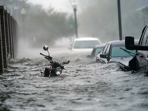
Hurricane Sally unleashes flooding along US Gulf Coast
Flash floods push water into homes in Alabama and Florida

Pensacola, Florida: (AP) Hurricane Sally lumbered ashore near the Florida-Alabama line Wednesday with 165 kmph winds and rain measured in feet, not inches, swamping homes and trapping people in high water as it crept inland for what could be a long, slow and disastrous drenching across the Deep South.
Moving at an agonising 5kmph, or about as fast as a person can walk, the storm made landfall at 4.45am near Gulf Shores, Alabama, after battering for hours a stretch of coastline that includes Mobile, Alabama, and Pensacola, Florida.
Flash floods pushed water into homes in Alabama and Florida, and officials in Pensacola and surrounding Escambia County, with a combined population of about 320,000, urged residents to stick to text messages for contacting family and friends to keep cellphone service open for 911 calls.
More than 2 feet of rain (61cm) was recorded near Naval Air Station Pensacola, and nearly 3 feet (1m) of water covered streets in downtown Pensacola, the National Weather Service reported.
“It’s not common that you start measuring rainfall in feet,” said National Weather Service forecaster David Eversole in Mobile, Alabama. “Sally’s moving so slowly, so it just keeps pounding and pounding and pounding the area with tropical rain and just powerful winds. It’s just a nightmare.”
Second hurricane in less than three weeks
It was the second hurricane to hit the Gulf Coast in less than three weeks and the latest blow in one of the busiest hurricane seasons ever recorded, so frenetic that forecasters have nearly run through the alphabet of storm names with 2 1/2 months still to go. At the start of the week, Sally was one of a record-tying five storms churning simultaneously in the Atlantic, strung out like charms on a bracelet.
Like the wildfires raging on the West Coast, the onslaught of hurricanes has focused attention on climate change, which scientists say is causing slower, rainier, more powerful and more destructive storms.
In Orange Beach, Alabama, winds blew out walls in one corner of a condominium building, exposing the interiors of condos on at least five floors, video posted online showed. Other images showed buildings with roof damage and stranded boats shoved onshore by storm surge.
At least 50 people in Orange Beach were rescued from flooded homes and taken to shelters, Mayor Tony Kennon said.
“We got a few people that we just haven’t been able to get to because the water is so high,” Kennon said. “But they are safe in their home, as soon as the water recedes, we will rescue them.”
Street lights knocked out
Street lights were knocked out in downtown Mobile, a city of about 190,000, where a stoplight snapped, swinging wildly on its cable. Trees were bent over as the rain blew sideways in the howling wind. In downtown Pensacola, car alarms went off, the flashing lights illuminating the floodwaters surrounding parked cars.
Before sunrise, water was up to the doors of Jordan Muse’s car outside the Pensacola hotel where her family took shelter after fleeing their mobile home a few miles away. The power failed early in the morning, making it too stuffy to sleep. Her 8-year-old son played with toys underneath the hotel room’s desk as Muse peered out the window, watching rain fly by in sheets.
“The power trucks are the only ones above water, and they’re the biggest,” Muse said. “I can’t believe it got so bad. That’s why we came here.”
Nearly a half-million homes and businesses had lost electricity by early Wednesday, according to the poweroutage.us site. A curfew was imposed in Gulf Shores hours before the storm’s arrival. Florida officials shut down a section of Interstate 10 near Pensacola because of high winds.
In Escambia County, Chief Sheriff’s Deputy Chip Simmons vowed to keep deputies out helping residents as long as possible.
“The sheriff’s office will be there until we can no longer safely be out there, and then and only then will we pull our deputies in,” Simmons said late Tuesday.
This for a storm that, during the weekend, appeared to be headed for New Orleans, about 320km to the west.
“Obviously this shows what we’ve known for a long time with storms - they are unpredictable,”Pensacola Mayor Grover Robinson IV said.
Catastrophic rain
National Hurricane Centre forecaster Stacy Stewart said the rain will be “catastrophic and life-threatening”over portions of the Gulf Coast.
The storm still had winds of 155kph more than two hours after it reached land. Forecasters warned that heavy rainfall would continue into Thursday as the storm moved inland over Alabama and into central Georgia, with the threat of serious flash flooding.
“Sally has a characteristic that isn’t often seen and that’s a slow forward speed, and that’s going to exacerbate the flooding,” said Ed Rappaport, deputy director of the hurricane center.
He likened the storm’s plodding pace to that of Hurricane Harvey, which swamped Houston in 2017.
Sally’s effects were felt all along the northern Gulf Coast. Low-lying properties in southeastern Louisiana were swamped by the surge. Water covered Mississippi beaches and parts of the highway that runs parallel to them. Two large casino boats broke loose from a dock where they were undergoing construction work in Alabama.
In Orange Beach, Alabama, Chris Parks, a tourist from Nashua, New Hampshire, spent the night monitoring the storm and taking care of his infant child as the winds battered his family’s hotel room. Their return flight home was canceled, so they were stuck in Alabama until Friday.
“I’m just glad we are together,”Parks said. “The wind is crazy. You can hear solid heavy objects blowing through the air and hitting the building.”


